DISASTER
RISK ASSESSMENT
Overview of Basic Principles and Methodology
George
Pararas-Carayannis
Copyright © 2006.
All Rights Reserved

 The destructive impact of recent natural disasters
on many regions of the world has brought into focus the need
for proper risk assessment, planning, preparedness and the implementation
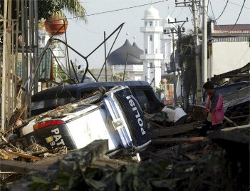
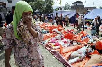
of early warning systems. The great earthquake and tsunami of
December 26 2004 near Sumatra affected 13 countries bordering
the Indian Ocean and was responsible for the deaths of more than
250,000 people. The great earthquake of 28 March 2005 in the
same general area caused additional devastation. The hurricanes
of 2005, and Katrina in particular, destroyed the city of New
Orleans and other well-developed communities in the Gulf of Texas.
The great earthquake of October 8, 2005 in Northern Pakistan
and Kashmir was a reminder of the degree of devastation and human
suffering disasters can cause. The destructive impact of recent natural disasters
on many regions of the world has brought into focus the need
for proper risk assessment, planning, preparedness and the implementation
of early warning systems. The great earthquake and tsunami of
December 26 2004 near Sumatra affected 13 countries bordering
the Indian Ocean and was responsible for the deaths of more than
250,000 people. The great earthquake of 28 March 2005 in the
same general area caused additional devastation. The hurricanes
of 2005, and Katrina in particular, destroyed the city of New
Orleans and other well-developed communities in the Gulf of Texas.
The great earthquake of October 8, 2005 in Northern Pakistan
and Kashmir was a reminder of the degree of devastation and human
suffering disasters can cause.
Regrettably, disasters
such as these occurred in regions known to be vulnerable but
where not proper risk assessment studies had been made and no
adequate plans for preparedness or mitigation existed. If such
studies had been properly made and plans were in place, the death
toll and destruction would have been minimized.
Unequivocally, disaster
mitigation requires accurate and expeditious assessment of all
potential risks, the issuance of prompt warnings, and programs
of preparedness that will assure warning effectiveness and public
safety. The methodology for assessing the potential risks that
threaten each region of the world requires adequate understanding
of the physics of each type of disaster, a good and expeditious
collection of historical data of past events, and an accurate
interpretation of this data as to what future impact will be.
Since each type of disaster results from different sources, the
risk assessment methodology will vary accordingly.
 Because of the extensive and
specialized nature of disasters, it is outside the scope of the
present report to provide a detailed analysis of how all risks
are determined for planning, zoning, construction or evacuation
purposes. Each disaster requires separate treatment and analysis.
The construction of important critical structures, such as nuclear
power plants, requires the adaptation of very conservative design
criteria. This report provides only a brief overview of general
principles that apply to the risk assessment of all types of
disasters. In the present report, disasters are examined from
a fundamental perspective, with emphasis on general techniques
that must be used in assessing risks, with emphasis on mitigation,
preparedness and public education. Because of the extensive and
specialized nature of disasters, it is outside the scope of the
present report to provide a detailed analysis of how all risks
are determined for planning, zoning, construction or evacuation
purposes. Each disaster requires separate treatment and analysis.
The construction of important critical structures, such as nuclear
power plants, requires the adaptation of very conservative design
criteria. This report provides only a brief overview of general
principles that apply to the risk assessment of all types of
disasters. In the present report, disasters are examined from
a fundamental perspective, with emphasis on general techniques
that must be used in assessing risks, with emphasis on mitigation,
preparedness and public education.
Satellite
image of Banda Aceh, in Sumatra, showing the extent of inundation
and destruction from the tsunami of December 26, 2004
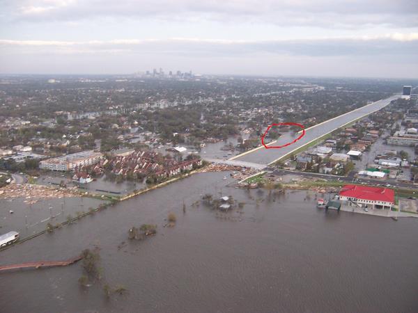
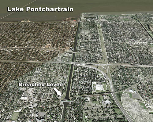
 The Hurricane
Surge Protective Defense Works in New Orleans were insufficiently
designed to prevent the flooding of hurricane Katrina. Levees
were breached or failed at considerable distance inland from
the shore of Lake Pontchartrain
The Hurricane
Surge Protective Defense Works in New Orleans were insufficiently
designed to prevent the flooding of hurricane Katrina. Levees
were breached or failed at considerable distance inland from
the shore of Lake Pontchartrain
 DISASTER RISK
ASSESSMENT
Overview of
Basic Principles and Methodology
TABLE OF CONTENTS
DISASTER RISK
ASSESSMENT
Overview of
Basic Principles and Methodology
TABLE OF CONTENTS
 UNDERSTANDING DISASTERS UNDERSTANDING DISASTERS
Natural Disasters
Man-Made Disasters
Natural Disasters with Anthropogenic Contribution
Global Warming
Other Anthropogenic Impact
Rare Disasters
Need to Mitigate Disaster
Impacts
Need for International Cooperation
Need for Advance Planning
1. REGIONAL IDENTIFICATION
OF DISASTER RISKS
1a. Development of Historical Databases
2. STATISTICAL METHODS
IN ESTABLISHING DISASTER RECURRENCE AND SEVERITY
2a. Disaster Frequency
2b. Statistics of Extreme Events
3. DISASTER MODELING
STUDIES
3a. Physical Scale
Modeling of Disasters
3b. Mathematical Modeling of Disasters
3b1. Tsunami Modeling
3b2. Hurricane (Typhoon) and Storm Surge Modeling
3b3. Hurricane Surge Modeling
3b4. Earthquake Disaster Modeling
3b5. Modeling Volcanic Eruptions
3b6. Tornado Modeling and Forecasting
3b7. Accuracy of Numerical Modeling
4. DISASTER RISK MAPPING
4a. Variation and
Acceptability of Risk
4b. Microzonation of disaster risks
4c. Map Scale Considerations
5. LAND USE ANALYSIS
5a. Loss Estimation Methodology
5b. Public Safety
5c. Transportation Systems Construction or Modification
5d. Sitting of Infrastructure Facilities
5e. Protective Defense Works
6. ENSURING THE SAFETY
AND RELIABILITY OF IMPORTANT INFRASTRUCTURE FACILITIES
6a. Engineering Design
Adequacy
6b. Need for Proper Building Codes and Engineering
7. SAFETY PLAN DURING
AND AFTER A DISASTER
7a. Post Disaster
Recovery Plan
8. DISASTER IMPACT
MITIGATION THROUGH PREPAREDNESS AND PLANNING
8a. Public Education
8b. Disaster Warning Systems
REFERENCES
 To read more
about disaster risk assessment, you may purchase this report
by clicking on the "select" link below. (45 pages, fully illustrated
in pdf format)
To read more
about disaster risk assessment, you may purchase this report
by clicking on the "select" link below. (45 pages, fully illustrated
in pdf format)
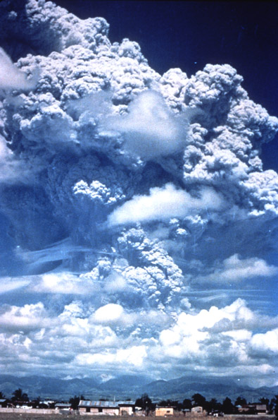
The 1991 eruption
of Mt Pinatubo in the Philippines affected the earth's global
warming and a higher average temperature in that particular year
 Return to

  Links to other
Pages
Links to other
Pages

 Now available
from Amazon, Barnes and Noble and other major bookstores. A signed
by the author copy can be also ordered by contacting directly
by email Aston
Forbes Press.
Now available
from Amazon, Barnes and Noble and other major bookstores. A signed
by the author copy can be also ordered by contacting directly
by email Aston
Forbes Press.
 Other
Miscellaneous Non-technical Writings
Other
Miscellaneous Non-technical Writings
(©) Copyright
1963-2007 George Pararas-Carayannis / all rights reserved / Information
on this site is for viewing and personal information only - protected
by copyright. Any unauthorized use or reproduction of material
from this site without written permission is prohibited.
|