THE
EARTHQUAKE OF JANUARY 8, 2006 IN SOUTHERN GREECE
George
Pararas-Carayannis

 Introduction Introduction
On Sunday January
8, 2006, a strong earthquake occurred in the sea along the Hellenic
arc, between the islands of Crete and Kythera in Southern Greece.
The earthquake, was strongly felt throughout Greece, from Crete
in the south to Kastoria in the north. Also, it was felt throughout
the Eastern Mediterranean Basin from Italy to Croatia and as
far away as Egypt, Cyprus, Israel, Turkey and Jordan.

Damages
The earthquake of
8 January 2006 caused damage to the airport facilities on the
Island of Kythera. About 50 old houses on the island eitherwere
damaged or collapsed. As with the 1903 magnitude 7.9 earthquake,
the village of Mitata suffered the greatest damage on the island.
Also, damage occurred at Chania, Crete.
Earthquake
Epicenter, Origin Time, Magnitude and Aftershocks
 The earthquake's epicenter was at 36.204 N, 23.444
E, in the southwest section of the "Hellenic Arc".
It was approximately 90 km (55 miles) NW of Chania, Crete, 150
km (95 miles) SE of Kalamata, 185 km (115 miles) WNW of Iraklion,
Crete, and about 200 km (125 miles) of Athens. The epicenter
of the earthquake is believed to be very close to that of the
365 A.D. earthquake - which was the largest earthquake to ever
occur in Greece, and had an estimated Richter magnitude of 8.3 The earthquake's epicenter was at 36.204 N, 23.444
E, in the southwest section of the "Hellenic Arc".
It was approximately 90 km (55 miles) NW of Chania, Crete, 150
km (95 miles) SE of Kalamata, 185 km (115 miles) WNW of Iraklion,
Crete, and about 200 km (125 miles) of Athens. The epicenter
of the earthquake is believed to be very close to that of the
365 A.D. earthquake - which was the largest earthquake to ever
occur in Greece, and had an estimated Richter magnitude of 8.3
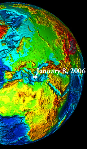
Epicenter of the January
8, 2006 earthquake (National Observatory of Athens, Geodynamic
Institute , Athens, Greece (NOA)
According to the Preliminary
Earthquake Report of the U.S. Geological Survey's National Earthquake
Information Center, the quake's Moment Magnitude (Mw) was 6.8.
The Athens Geodynamic Institute reported the Moment Magnitude
to be 6.9. The origin time was 11:34:53 UTC (1:34:53 PM , Sunday,
January 8, 2006 Greek local time). The focal Depth was initially
reported to be 48.4 km (30.1 miles), byt the Geodynamic Institute
in Athens revised it to 69 km. Numerous aftershocks struck the
area following the main earthquake, some as large as magnitude
5.
 Sattelite
Photo of Peloponissos and the Island of Kythira at the lower
right
Sattelite
Photo of Peloponissos and the Island of Kythira at the lower
right
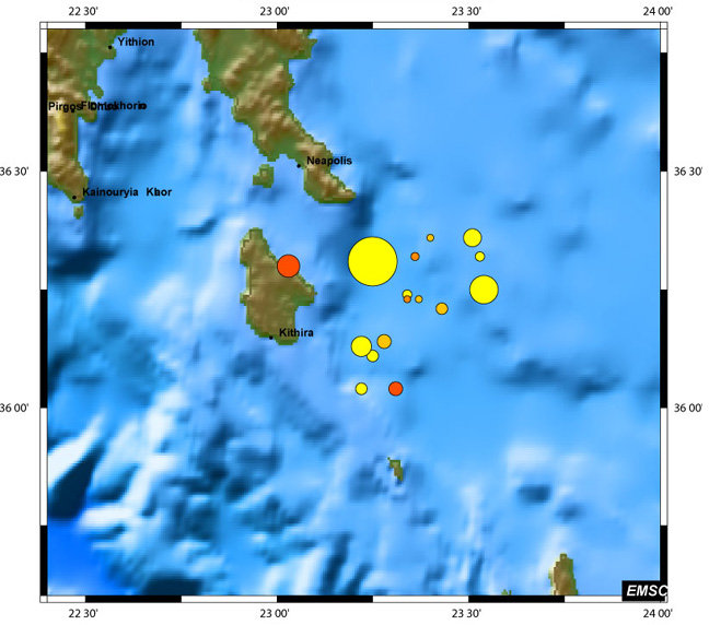 Aftershocks
in the days following the Earthaquake of January 8, 2006. Size
of circles indicates the magnitudes of the aftershochks Stongest aftershocks ooccurred
on January 8, 2006 (Modified graphic of the European-Mediterranean
Seismological Center)
Aftershocks
in the days following the Earthaquake of January 8, 2006. Size
of circles indicates the magnitudes of the aftershochks Stongest aftershocks ooccurred
on January 8, 2006 (Modified graphic of the European-Mediterranean
Seismological Center)

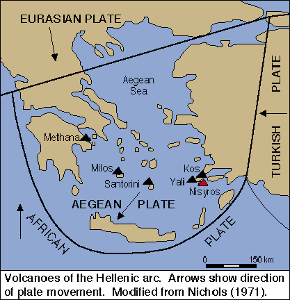
Tectonic
Setting - The Hellenic Arc
Formation of the Hellenic
Arc - Three major tectonic plates, the Eurasia, Africa, and Arabia
plates meet in the eastern Mediterranean and have formed broad
boundaries of seismic and volcanic activity. Greece is located
near the boundary of the two great lithospheric plates of Africa
and Eurasia. The interaction of the great plates results in numerous
earthquakes.
 The
northern segment of the African plate south of the Adriatic Sea
comprises of the Eastern Mediterranean oceanic lithosphere. Collision
of the lighter-density oceanic eastern Mediterranean with the
higher density continental lithosphere of Eurasia - part of which
is the Aegean Sea subplate - has formed an arcuate zone of subduction
along their boundary. Therefore, subduction of the Africa plate
beneath the Aegean Sea plate has formed the Hellenic Arc, which
is a zone of active seismicity which extends along Western Peloponnesus
and continues along the islands of Kythera and Antikythera to
south of Crete, then to Rhodes and Western Turkey. The
northern segment of the African plate south of the Adriatic Sea
comprises of the Eastern Mediterranean oceanic lithosphere. Collision
of the lighter-density oceanic eastern Mediterranean with the
higher density continental lithosphere of Eurasia - part of which
is the Aegean Sea subplate - has formed an arcuate zone of subduction
along their boundary. Therefore, subduction of the Africa plate
beneath the Aegean Sea plate has formed the Hellenic Arc, which
is a zone of active seismicity which extends along Western Peloponnesus
and continues along the islands of Kythera and Antikythera to
south of Crete, then to Rhodes and Western Turkey.
Modified After Nafi
Toksoz of MIT/ERL
Paralleling the Hellenic
Arc is the volcanic Arc which includes the volcanoes of Methana,
Milos, Santorin and Nisyros. The plate movements and the associated
earthquakes have also formed a series of sea basins extending
from Kefalonia to Rodes.
The seismotectonics
of Greece's southern region are controlled primarily by the interaction
of the Africa tectonic plate with the small Aegean Sea plate
along the Hellenic Arc. Most of the earthquakes near the Arc
are shallow but further away from it the focal depths are intermediate.
 The
rate of subduction along the Hellenic Arc is estimated to be
35- 40 mm/year. Most of the earthquakes that occur west and northwest
of Crete near the Hellenic arc plate boundary are relatively
shallow, with focal depths of less than 50 km. The
rate of subduction along the Hellenic Arc is estimated to be
35- 40 mm/year. Most of the earthquakes that occur west and northwest
of Crete near the Hellenic arc plate boundary are relatively
shallow, with focal depths of less than 50 km.
Differences in the
rates of extension of two adjacent major segments of the external
Western Hellenic Arc have created the Kythera Strait - a zone
of complex, active, transform-extensional deformation and rotation
(Lyberis et al.,1982). Oblique, en echelon, normal faulting indicates
a pattern of dextral deformation.
The seismic slip along
the Kythira Strait is estimated at about 30 mm/yr (Papadopoulos
1989). With such high rate of seismic slip, the Kythera Strait
can generate large shallow and intermediate-depth earthquakes
- with Richer magnitudes of up to about 8.0 (Papazachos, 1996
; Papazachos and Papazachou, 1997) .
The earthquake of
January 8, 2006 occurred along the Kythera Strait deformation
zone and its focal depth of 48.4 km was close to the upper limit
for earthquakes in this region.
TYPE OF
CRUSTAL DISPLACEMENTS AND RUPTURE ASSOCIATED WITH THE EARTHQUAKE
OF JANUARY 8, 2006
Most of the earthquakes
in this particular region of the Greek Arc involve reverse as
well as strike slip motion and some normal faulting motion. The
earthquake of January 8, 2006 involved inverse but mostly lateral
movement. The African plate is estimated to have moved in a northern
direction by about 90 centimeters in relation to the Aegean Sea
plate and to have subducted beneath it. The long duration of
the shaking (about 30 seconds), indicates a long rupture (perhaps
as 50-60 km or even more).
 ( Seismicity of Greece - Epicenters
of the September 7, 1999 earthquake - Modified USGS map) ( Seismicity of Greece - Epicenters
of the September 7, 1999 earthquake - Modified USGS map)
The energy of the
8 January 2006 earthquake was 33 times greater than that of the
September 7, 1999 earthquake in Central Greece which had a Richter
magnitude of 5.9.
HISTORICAL
EARTHQUAKES ALONG THE WESTERN HELLENIC ARC AND IN THE STRAIT
OF KYTHIRA
The historical record
indicates that the southwestern region of Greece is vulnerable
because of the high seismic potential of the southwestern segments
of the Hellenic Arc. The Kythera Strait zone of deformation has
a particularly high seismic potential. Many large earthquakes
have occurred in this region in the past. Unfortunately, there
is no adequate documentation for events prior to 1750. Some of
the earliest large earthquakes occurred in 66 A.D., in 365 AD
(near Crete), in 800 A.D., and in 1303 AD.
There is better documentation
for the more recent events. At least ten strong earthquakes were
documented for the period from 1750 to 1910 with magnitudess
Ms+6.0 or more. The mean recurrence was estimated to be of about
18±18 years (Papadopoulos & Vasssilopoulou 2001).
Best known of the
more recent events is the destructive Kythera earthquake of 11
August 1903. After 1910, when systematic instrumental seismic
recording begun in Greece, the documentation of earthquakes in
the region improved.
Since 1910, the Institute
of Geodynamics, National Observatory of Athens, recorded three
strong earthquakes in the Kythera Strait - on March 18, 1937
(Ms = 6.0), on June 21, 1984 (Ms = 6.2), and November 21, 1992
(Ms = 6.5).
Recently, a historical
data bank of earthquakes in the region was compiled from various
sources in support of an experimental regional tsunami warning
system for the Kythera Strait (Papadopoulos & Vasssilopoulou
2001). The Catalog of historical earthquakes for the region of
Kythera Island that has been compiled shows about 55 events.
Some of these earthquakes generated tsunamis. Most noteworthy
of the earthquakes that were destructive at Kythira are the following:
Earthquake of 5 June
1750 - An earthquake
on June 7, 1750 killed about 2,000 people at Kythera and caused
considerable destruction on the island.
Earthquake of 11 August
1903 - A major earthquake
(Ms about 7.9) on August 11, 1903 - with epicenter at sea south
of Kythera - devastated the island. The shock was felt throughout
Greece and as far away north as Trieste, as well as in South
Italy, Egypt and Turkey. The quake killed four people, injured
another ten and inflicted heavy damage on the island pf Kythera.
Hardest hit on the
island was the village of Mitata which is located on ground consisting
of alluvial deposits. A church and a school building collapsed
and about 80 houses were damaged or destroyed. Also destroyed
was the villages of Variadika and Kapsali. Many houses were destroyed
in Avlemona (Papazachos and Papazachou 1997). Extensive damage
occurred in Peloponnisos (Leonidio Kynourgia, Korinth), in the
island of Santorin, and as far away as Southern Italy and Sicely.
FUTURE EARTHQUAKES
IN THE SOUTHWESTERN REGION OF GREECE
Seismic activity in
the area can be expected in the form of diminishing aftershocks
following the major earthquake of 8 January 2006. Usually, when
a strong earthquake occurs, most of the stress is relieved and
another large earthquake may not occur for many years in the
same region. However, this is not always the case, as dynamic
stress loading can accelerate the occurrence of another earthquake
along an adjacent seismic zone.
As a result of such
stress load transfer, another earthquake in an adjacent fault
along the southwestern segments of the Hellenic Arc is possible.
However, such an earthquake may not occur for months or even
years from now. When such an event will occur again, is not known
with any degree of certainty. The only thing known with certainty
is that it will occur in this or an adjacent region. A stress
transfer analysis based on the study of rupture parameters and
the geometric distribution of aftershocks, could help establish
the space-time evolution of stresses and help determine both
static and dynamic modifications that could possibly trigger
future events along the known faults in this southwestern region
of Greece.
WHY NO TSUNAMI
WAS GENERATED BY THE EARTHQUAKE OF 8 JANUARY 2006?
The strait of Kythera
is an area of high seismicity where major tsunamigenic earthquakes
have generated destructive tsunamis in the past and will do so
again in the future. Whether a major earthquake will generate
a tsunami depends on its magnitude and energy release, its focal
depth and location of the source area, and the type and extent
of crustal displacements on the sea floor. Depending on the type
of faulting motion, net crustal displacements and water depth,
tsunami generation is possible in this area.
Most of the earthquakes
in the Kythera Strait involve reverse as well as strike slip
motion and some normal faulting motion. The earthquake of January
8, 2006 occurred east of the subduction boundary and involved
mostly lateral strike slip movement. Also, it had a greater focal
depth (48.4 km, revised later to 69 km) and occurred in a region
where the water was quite deep. All these were reasons - particularly
the earthquake's focal depth - why no tsunami was not generated.
If indeed a small tsunami was generated - there may be some evidence
of it. It is possible that tide gauges that may have been operating
at some port facility may have recorded a small sea oscillation.
TSUNAMIS
IN THE SOUTHWESTERN REGION OF GREECE
The Kythera Strait
is an area of high seismicity in Greece where strong earthquakes
have occurred with frequency. Some of these earthquakes generated
tsunamis. The historic record documents that earthquakes generated
at least five destructive tsunamis since the 1st Century. These
five do not include a tsunami from the questionable earthquake
of 800 AD or the tsunami (s) associated with the eruptions, explosion
and collapse of the volcano of Santorin around 1625 B.C.
As already mentioned,
the Geodynamic Institute of Athens has included in its historical
earthquake data bank tsunami data from various sources in support
of an experimental regional tsunami warning system for the Kythera
Strait. Based on the limited available historic data, the mean
recurrence frequency of tsunamis in the Kythira strait has been
estimated to be 130 years (Papadopoulos & Vasssilopoulou
2001). Additional data on historical tsunamis in the Eastern
Mediterranean, the Aegean and the Ionian Seas can be found at
this web site under the title "Tsunami Potential of Greece"
 Tsunamis that Have
Affected the Island of Kythera. Tsunamis that Have
Affected the Island of Kythera.
A cursory field survey
of Kythera Island was undertaken by the author in October 2005
to examine suspected past collapses of coastal areas and possible
evidence of palaiotsunami inundation. The geologic formations
and coastal geomorphology indicated that large scale landslides
and mass edifice coastal collapses have indeed occurred on the
island. Such coastal failures and subsidence appear to have occurred
in the region of Palaiopolis and elsewhere on the island - where
Minoan or Mycenean settlements existed. There is also evidence
of tsunami inundation from past events - probably from the Minoan
and subsequent tsunamis - in Agia Pelagia, Palaiopolis, Kastri
and Avlemonas, on the east side of the island and at Kapsali
on the southern coast.
No volcanic ash from
the great eruption of Santorin was found - as expected. However
the survey was preliminary and will be continued in the future
on both Kythera and Antikythera island to the south. It is very
possible that the prevailing winds at the time of the great Minoan
eruption of Santorin carried the vocanic ash mostly in a southern
rather than a westerly direction.
Depositional patterns
on the Island of Santorin (at Akrotiri) - also examined in September
2005 - indicate that the prevailing winds were from the north,
which would indicate that the great paroxysmal eruption and tsunami
occurred during the summer months.
The following listing
of tsunamis that have affected the island of Kythera, Crete and
islands of the Cyclades is based on cursory review of existing
literature including the thorough study by the Athens Geodynamic
Institute (Papadopoulos and Vassilopoulou, 2001). Unfortunately,
even though the literature is extensive, no specific details
are provided for most of the known tsunamis that have struck
the island.
1625 B.C. - The paroxysmal eruptions and
explosion of the Santorin volcano around 1625 B.C. generated
a large tsunami which undboutedly reached and caused damage to
any Minoan or Mycenean settlements on the east coast of the island
of Kythira.
66 A.D. - An earthquake in the Kythera
Strait generated a tsunami. The island of Kythera was impacted
by the combined effects of the earthquake and the tsunami. No
details available.
365 A.D. - The earthquake of 365 A.D. in
the Kythera Strait is believed to be the strongest historical
earthquake that ever occurred in Greece. Its Richter magnitude
is estimated to have been about 8.3. and it impacted the greatest
part of the Roman empire. Knossos on Crete was destroyed by the
earthquake. There was heavy damage from the earthquake at Gortyna
and in Patra and throughout the provinces of Ahaia and Viotia
on Peloponissos. The destructive tsunami that was generated struck
the islands of Kythera, Crete and Cyclades, Peloponissos and
many other coastal areas in the Aegean and Ionian Seas and as
far away as Epirus, Sicely and elsewhere in the Metiterranean.
The tsunami struck and destroyed at least ten coastal cities
on Crete.
Skandia, the ancient
harbour of Kythera on the east side of the island , was destroyed
by the combined effects of the earthquake and the tsunami. No
specific information for this event is available in the historic
records.
 800 A.D. - The occurrence of another large tsunamigenic
earthquake in the year 800 A.D. remains questionable. It may
have been confused with an earthquake which occurred in 796.
It must be assumed that if indeed the earthquake occurred - whether
in 796 or in 800 A.D. - it must have generated a destructive
tsunami that struck Ancient Skandia and other coastal settlements
on the island of Kythera. 800 A.D. - The occurrence of another large tsunamigenic
earthquake in the year 800 A.D. remains questionable. It may
have been confused with an earthquake which occurred in 796.
It must be assumed that if indeed the earthquake occurred - whether
in 796 or in 800 A.D. - it must have generated a destructive
tsunami that struck Ancient Skandia and other coastal settlements
on the island of Kythera.
Cliffs at Palaiapolis,
on the East Coast of Kythera Island, near ancient settlements,
where massive coastal edifice failures have occurred and tsunamis
have struck (photo: G Pararas-Carayannis, Oct. 2005)
1629 or 1630 - An earthquake in the Kythera
Strait generated a tsunami. Serious damage and some deaths occurred
at Heraklion and elsewhere in Crete. No details are available
on whether the damage and the deaths on Crete were caused by
the tsunami or what the effects of the earthquake and of the
tsunami were on Kythira Island.
1866 - A strong earthquake in the Kythera
Strait on 6 February 1866 generated a tsunami. There was significant
earthquake damage to Kythira The tsunami reached a runup height
of 8 meters at Avlemonas on the eastern side of Kythera island
and caused damage to houses (Fuchs 1886, Leonhard 1899).
1867 - A strong earthquake on 20 September
1867 with epicenter near Mani in south Peloponisos generated
a strong tsunami. There was heavy damage in Peloponisos and slight
damage at Kythira. The tsunami affected coastal areas at Kythira,
Crete and Cyclades and reached islands in the Ionian and south
Adriatic seas (Papazachos and Papazachou, 1997).
1886 - A large, destructive, earthquake
on 2 7 August 1886 in SW Peloponnisos generated a local tsunami(Galanopoulos,
1941 and Papazachos and Papazachou 1997). The quake was slightly
felt in Kythera (Galanopoulos, 1953). No details about the tsunami
are available.
9 July 1956 - The best documented tsunamigenic
earthquake in the Aegean Sea is the one that occurred on 9 July
1956 near the southwest coast of the island of Amorgos, killing
53 people, injuring 100, and destroying hundreds of houses. The
waves were particularly high on the south coast of Amorgos and
on the north coast of the island of Astypalaea. At these two
places the reported heights of the tsunami were 25 and 20 meters,
respectively. The tsunami must have struck the island of Kythera
but no details are available.
References
(cited and uncited)
Angelier J., Lyberis N., Le Pichon
X., Barrier E. and Huchon P. (1982). The tectonic development of the Hellenic arc
and the Sea of Crete : a synthesis.
Tectonophysics, 86, 159-196.
Angelier J. (1979). Recent quaternary tectonics in the Hellenic Arc:
examples of geological observations on land.
Tectonophysics, 52, 267-275.
Fuchs, C. W., 1886.
Statistik der Erdbeben
von 1865 his 1885,
Silzungsberichte der Mathemat. Naturwissenschaftlirhen Classe
der Kaiserlirhen Akademie der Wissenschaften. 92, Wien.
Lyberis, N. J. Angelier,
E. Barrier, and S. Lallemant, 1982: Active deformation of a segment of arc: the strait
of Kythira, Hellenic arc, Greece, J. Structural Geology, 4, 299-311.
Galanopoulos, A., 1953. Katalog
der Erdbeben in Griechenland fur die Zeit von 1879 bis 1892. Ann. Geol. Pays Helleniques, 5, Athens.
Leonhard, R., 1899.
Die Insel Kythera
- Eine geographische Monographie, Library of Historical Studies, 182, Athens,
47pp.
Pararas-Carayannis, G. 2001. The Tsunami Potentila of Greece, http://drgeorgepc/TsunamiPotentialGreece.html
Papadopoulos, G.A.,
1989. Seismic and
volcanic activities and aseismic movements as plate motion components
in the Aegean area,
Tectonophysics, 167, 31-39.
Papadopoulos G.A.
and A Vassilopoulou, 2001 HISTORICAL
AND ARCHAEOLOGICAL EVIDENCE OF EARTHQUAKES AND TSUNAMIS FELT
IN THE KYTHIRA STRAIT, GREECE
Institute of Geodynamics, National Observatory ofAthens, 11810
Athens Greece
Papazachos, B.C.,
1996. Large seismic
faults in the Hellenic arc,
Annali di Geofisica, 39, 891-903.
Papazachos, B. C.
and K. Papazachou, 1997. The
Earthquakes of Greece,
Ziti Editions, Thessaloniki, 304pp.
Links to
other Web Sites for More Information
Tsunami
Potential in Greece.html
National Observatory of Athens, Geodynamic Institute
, Athens, Greece (NOA)
Department of Geophysics, University of Thessaloniki
Thessaloniki, Greece
European-Mediterranean Seismological Centre
Kandilli
Observatory and Earthquake Research Institute Istanbul, Turkey
Return to

  Links to other
Pages
Links to other
Pages

 Now available
from Amazon, Barnes and Noble and other major bookstores. A signed
by the author copy can be also ordered by contacting directly
by email Aston
Forbes Press.
Now available
from Amazon, Barnes and Noble and other major bookstores. A signed
by the author copy can be also ordered by contacting directly
by email Aston
Forbes Press.
 Other
Miscellaneous Non-technical Writings
Other
Miscellaneous Non-technical Writings
(©) Copyright
1963-2007 George Pararas-Carayannis / all rights reserved / Information
on this site is for viewing and personal information only - protected
by copyright. Any unauthorized use or reproduction of material
from this site without written permission is prohibited.
|