|
HURRICANE
CAMILLE - August 14-22, 1969
Worse than Katrina, Camille barely spared New Orleans from destruction
(Lessons we did not learn)
George
Pararas-Carayannis
Excerpt
from a study performed for the U.S. Army Coastal Engineering
Research Center under contract with the U.S. Nuclear Regulatory
Commission

INTRODUCTION
The year 1969 had
an unusually large number of tropical storms that progressed
in odd and abnormal patterns. One of those was a hurricane named
Camille. In August 1969, Camille developed into one of the most
devastating hurricanes in U.S. history up to that time. It raced
across the Gulf of Texas, heading straight for New Orleans. Fortunately
Camille changed direction, sparing New Orleans from destruction.
Instead, it made landfall to the east, tearing into the coasts
of Eastern Louisiana and Mississippi, and spreading death and
destruction across its path. A total of 262 people lost their
lives in seven states from Louisiana to Virginia. However, the
total damage was very high at about $1.5 billion (in 1969 dollars)
- most from extremely high hurricane surges (U.S. Army Engineer
District, Mobile, 1970).
 Camille's Evolution Camille's Evolution
The storm originated
off the coast of Africa on 5 August 1969. It was recognized as
a tropical disturbance on the 9th, when it was about 480 miles
east of the northern Leeward Islands. By 14 August, near the
island of Grand Cayman in the Caribbean, the storm had developed
a 29.50 inches of mercury (999 millibars) pressure center and
surface winds of 55 miles per hour. The disturbance was christened
Tropical Storm Camille.
Tropical Storm Camille
moved northwestward at 9 miles per hour and its central pressure
dropped to 29.26 inches of mercury (991 millibars) late on the
14th. By 15 August, Camille was located 60 miles southeast of
Cape San Antonio, Cuba, and had developed into a full hurricane
with 28.47 inches of mercury (964 millibars) central pressure
and winds of 115 miles per hour (DOE Angelis, 1969). The hurricane
moved into the Gulf of Mexico on the 16th and changed to a north-northwestward
direction with a translational speed of 14 miles per hour. By
then, its central pressure had dropped to 26.72 inches of mercury
(905 millibars).
Hurricane
Watches Issued Westward to New Orleans
Hurricane watches
were set up from Biloxi, Mississippi, to St. Marks, Florida.
On 17 August, Camille was 250 miles south of Mobile, Alabama
with surface winds near the center estimated at more than 201.5
miles per hour. Hurricane warnings were issued for the Mississippi
coastal areas extending westward to New Orleans.
 Hurricane Camille's 30-ft surface
isovels (knots) as it neared landfall near New Orleans on August
17, 1969 (Source: Environmental Services Service Administration
(HUR 7-113A, 1970) Hurricane Camille's 30-ft surface
isovels (knots) as it neared landfall near New Orleans on August
17, 1969 (Source: Environmental Services Service Administration
(HUR 7-113A, 1970)
Camille
Makes Landfall at Waveland and Bay St. Louis, Louisiana.
The center of Hurricane
Camille made landfall at Clermont Harbor, Waveland, and Bay St.
Louis, Louisiana at about 2330 hours CDT on the 17th. There were
no records of winds near the center, but estimates ranged up
to 201.5 miles per hour. A Transworld oil rig platform tower
recorded gusts up to 172-mph before failing.
At the west end of the Bay St. Louis Bridge a pressure of 26.85
inches of mercury (909.3 millibars) was reported. This is the
second lowest barometric pressure ever measured in the United
States. Only the 1935 Hurricane produced a lower pressure in
the middle Keys of 892 Mb (26.35). At Boothville, Louisiana,
winds of 107 miles per hour were recorded before a power failure;
at Pilottown, Louisiana, the S.S. Cristobal estimated
winds at 160 miles per hour. Winds at Keesler Air Force Base,
Biloxi, Mississippi were measured at 81 miles per hour with gusts
to 129 miles per hour. At Ingalls Shipyard, Pascagoula, Mississippi
the highest sustained wind reached 81 miles per hour while a
local radio station reported 104 miles per hour winds before
power failure.
Overall it is estimated
that Camille (a Category 5 hurricane) had sustained winds of
180 - 190-mph and gusts of as much as 210 - 220 mph.

 Hurricane
Camille's 30-ft surface isovels (knots) as it neared landfall
near New Orleans on August 18, 1969 (Source: Environmental Services
Service Administration (HUR 7-113A, 1970)
Hurricane
Camille's 30-ft surface isovels (knots) as it neared landfall
near New Orleans on August 18, 1969 (Source: Environmental Services
Service Administration (HUR 7-113A, 1970)
Flooding
by Hurricane Camille's Surges
Hurricane-force winds
were concentrated close to Hurricane Camille's center as it moved
inland. These winds extended from east of New Orleans to Pascagoula,
while gusts of hurricane force winds extended along the coast
from New Orleans to west of Mobile Bay.
Hurricane Camille
generated extremely high surges - the highest recorded in the
U.S, up to that time. Storm surges flooded coastal regions from
lower !laquemines Parish in Louisiana, to Perido Pass, Alabama.
Maximum storm surge of 24.6 feet above MSL was measured in the
Pass Christian-Long Beach, Mississippi, area. In St. Louis Bay,
maximum surge was 18 feet above MSL. At Back Bay of Biloxi, Mississippi,
the surge elevation reached about 15 feet above MSL (U.S. Army
Engineer District, Mobile,1970), and near 10 feet above MSL as
far east as the Mississippi-Alabama border.
Along the Louisiana
coast, the storm surge was 15 feet above MSL at Boothville, and
9 feet above MSL near the mouth of the Mississippi, at Garden
Island. At Alluvial City surge height reached 7.97 feet above
MSL, at Chef Menteur Pass 11.06 feet, at Shell Beach 11.06 feet,
and at Rigolets 9 feet. Detailed maps of areas flooded and surge
measurements of Hurricane Camille can be found in the publication
by Wilson and Hudson (1969). Additional surge elevations along
the Louisiana and Mississippi coasts are shown in the adjacent
figure.
 Hurricane
Camille track, windspeeds and resulting surges along the Mississippi
Coast.
Hurricane
Camille track, windspeeds and resulting surges along the Mississippi
Coast.
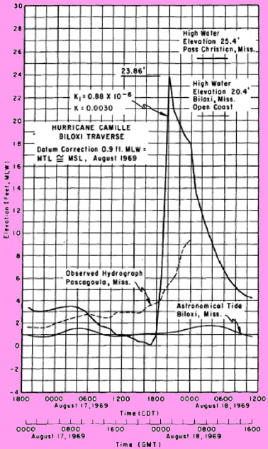
Surge data along the
coast of Louisiana, Mississippi and Alabama, can be found in
the U.S. Army Engineer District, Mobile Report (1970). The surge
elevation of 19.5 feet above MSL used for the calibration of
a mathematical model by the author of this article is based only
on a visual observation of high water mark at Biloxi, Mississippi
(see Figure below). This value may include runup due to wave
action.
 Destruction by Hurricane Camille and
its Surges. Destruction by Hurricane Camille and
its Surges.
Most of the deaths
and destruction were caused by Camille's storm surges. The destruction
was unprecedented and left at least 15,000 people homeless. The
entire infrastructure of the region was destroyed - roads, bridges,
railaways and airports. Thousands of farm and domestic were drowned.
NOAA photo of destruction.
Camille
Moves Inland
Once over land, Hurricane
Camille weakened considerably moving northward through Mississippi,
passing close to Columbia, Prentis, Jackson, Canton, and Greenwood.
At Jackson, winds gusted to 67 miles per hour as the storm center
passed 10 miles west of the city. Torrential rainfall caused
devastating flash floods and landslides along the eastern slopes
of the Blue Ridge Mountains and record flooding along the James
River. Flush floods swept away roads, bridges, and buildings.
More than 100 people were killed in Virginia and Tennessee. The
storm weakened and was only identifiable as a depression by the
time it reached the northern Mississippi border and was tracked
northward to southern Virginia.

Camille's Path
Mathematical
Modeling of Hurricane Camille' Surge at Biloxi, Missisippi.
A study of hurricane
Camille was undertaken by Pararas-Carayannis (1975) for the purpose
of verifying a mathematical model on the maximum hurricane surge
flood as it compared with the observed maximum surge height observed
at Biloxi, Mississippi. The following hurricane parameters were
used for the calculation.
Central pressure - 27.63
Peripheral pressure - 2 9.92
Radius to Max. wind
(naut. miles) - 14.0
Translation speed
(knots) - 13.0
Maximum Gradient
Wind (miles per hour)
- 125.0
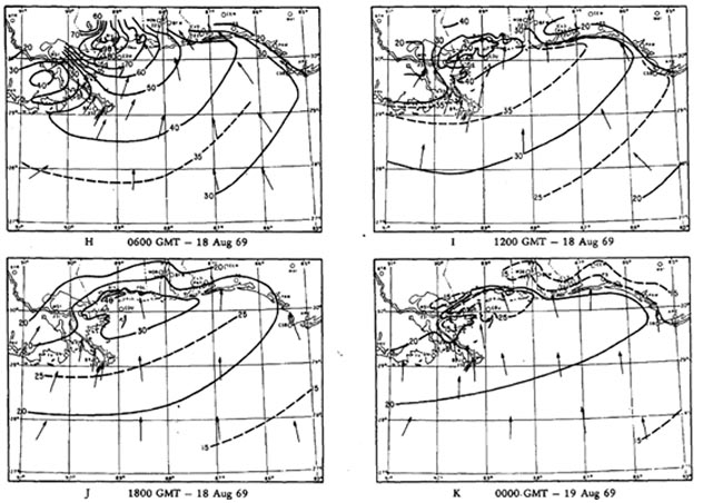
The surface wind fields
and pressure fields of Hurricane Camille were obtained from the
Hydro-Meteorological Reports HUR 7-113, and 7-113A (Environmental
Science Services Administration (ESSA), 1969 and 1970). In the
latter report wind fields were given at 6-hour intervals from
0000 hours through 1800 hours GMT, 17 August, then at 3-hour
intervals through 0500 hours GMT, 18 August, and then at 6-hour
intervals until 0000 hours GMT, 19 August (see isovel charts
for 17 and 18 August 1969). These were the synoptic weather charts
used in the modeling study. The map below shows the traverse
for Hurricane Camille that was used for the calculation.
Computational
Traverse
The traverse was selected
to the right of Camille's track, to accommodate a limitation
of the bathystrophic numerical model for surge computation (preferably
at a distance of about 1-3 times the radius to maximum winds
away from the path of the hurricane center and in order to intercept
the maximum effect of the hurricane.
The traverse at Biloxi
was selected as this location was on the open coast where large
surge water levels were observed and documented and was nearer
the tide gage at Pascagoula, Mississippi, where some tidal information
could be obtained. Because of the Mississippi River Delta and
the offshore islands, and the lack of sufficient wind field and
hydrograph data, Biloxi was a poor site for the numerical calculations
of surge. A better traverse may have been Pass Christian, Mississippi,
where maximum surge for this hurricane occurred; however, it
was not selected because of the unusual coastal configuration
of the region and the presence of offshore islands.
The shore-intercept
of the Biloxi traverse used in the computations was at 30°23'N,
88°52'W. It began 77 nautical miles from the shore at a depth
of 600 feet on the Continental Shelf - using mean low water (MLW)
as the reference datum. The bathymetry for the profile was taken
from detailed nautical charts. The traverse's orientation was
S 12°E. The bearing was established by a perpendicular orientation
to the offshore bathymetric contours.
 The landfall
track for Hurricane Camille and the traverse used for the calculation
of maximum surge height.
The landfall
track for Hurricane Camille and the traverse used for the calculation
of maximum surge height.
Other Computational
Parameters
It is outside the
scope of this report to present details of the computation. However
there were a number of corrections applied for water level datum
and phase of the predicted astronomical tide - in reference to
MLW. The astronomical tide at the time of maximum surge inundation
at Biloxi was determined to be 1.60 feet above MLW. Other hydrographic
data of major importance in the calculation of the maximum storm
surge involved the estimate of the initial rise in water level
preceding the arrival of Camille. Such water level deviationscan
be as much as 2 feet.
 The
initial rise used as input to the numerical calculation of the
storm surge was the average difference between the predicted
astronomical and the observed tide at or closest to the shore-intercept
point (on an open coast) of the traverse before the influencing
effects of hurricane winds and pressures. This initial rise was
estimated to be 1.2 feet at Biloxi. In the numerical calculations
this value was treated as a constant and added to the total water
level. This may have been an oversimplification, since the cause
for such initial rise or its exact magnitude during the passage
of the storm is not known with certainty. This could also account
for the difference found between observed and computed maximum
surge flooding at Biloxi. The
initial rise used as input to the numerical calculation of the
storm surge was the average difference between the predicted
astronomical and the observed tide at or closest to the shore-intercept
point (on an open coast) of the traverse before the influencing
effects of hurricane winds and pressures. This initial rise was
estimated to be 1.2 feet at Biloxi. In the numerical calculations
this value was treated as a constant and added to the total water
level. This may have been an oversimplification, since the cause
for such initial rise or its exact magnitude during the passage
of the storm is not known with certainty. This could also account
for the difference found between observed and computed maximum
surge flooding at Biloxi.
Finally, values of
relative wind stress k, and bottom friction, K, coefficients
were applied to the numerical equations used for the surge computation.
The constants K1 and K2 that were used account for pressure,
density, precipitation, temperature and other factors of a hurricane
system, which are not easily measured, and can only be obtained
empirically.
Results
of the Computation
There was inadequate
correlation between the computed hurricane surge hydrograph and
the observed high water elevation at Biloxi. This was attributed
to insufficiency of accurate wind-field information and the irregularity
of the coastline. Furthermore, Camille's wind-field charts were
available for only 6-hour intervals and the highest surge occurred
sometime between the times shown in these charts. Furthermore,
in 1969, there were no synoptic measurements of hurricane winds
or satellite imagery - as readily available presently.
Observed and computed
surge hydrographs for Hurricane Camille at Biloxi, Mississippi
with datum corrections and optimal bottom frictional coefficient
and surface wind stress.
Additionally, the
interpolated wind field for that period that was used in the
calculation probably did not accurately represent actual wind
conditions, which produced the maximum surge. Similarly, there
was no operating tide gauge and therefore no hydrograph at the
point of the coast where the maximum surge occurred. As mentioned
previously, the nearest tide gage station from which a partial
record of this event could be obtained, was at Pascagoula, Mississippi.
The peak surge provided as maximum at Biloxi for this location
(19.5 feet above MSL) was based on a visual observation. The
value was based on an observed elevation extrapolated from debris
and high water marks and may have included the effects of wave-induced
run-up. A more accurate value for Biloxi would be 20.4 feet.
In the case of the Biloxi traverse the numerical model tended
to overestimate the hurricane surge height, by about 15%. However,
given the uncertainty of the wind data, this deviation is statistically
acceptable. With good synoptic wind data, satellite imagery,
better determination of hurricane parameters and modern fast
computers, present mathematical models can estimate the maximum
hurricane surge with greater accuracy.

REFERENCES
ENVIRONMENTAL SCIENCE
SERVICES ADMINISTRATION, "Preliminary Analysis of Surface
Wind Field and Sea-Level Pressures of Hurricane Camille, August
1969," Hydrometeorological Branch, HUR 7·113, Rockville,
Md., Nov. 1969.
ENVIRONMENTAL SCIENCE
SERVICES ADMINISTRATION, "Revised Surface Wind Field (30
ft.) of Hurricane Camille in Gulf of Mexico August 1969,"
Hydrometeorological Branch, HUR 7-113a, Rockville, Md., Mar.
1970.
Pararas-Carayannis,
G. 1975, Verification Study of a Bathystrophic Storm Surge Model.
U.S. Army, Corps of Engineers Coastal Engineering Research Center,
Washington, D.C., Technical Memorandum No. 50, May 1975.
U.S. ARMY ENGINEER
DISTRICT, MOBILE, "Hurricane Camille, 14-22 August 1969,"
Mobile, Ala., May 1970.
WILSON, K. V., and
HUDSON, J. W., "Hurricane Camille Tidal Eloods of August
i969, Along the Gulf Coast, Biloxi' Quadrangle, Mississippi,"
Atlas HA-395-408, U.S. Geological Survey, Washington, D.C., 1969.
Return to

  Links to other
Pages
Links to other
Pages


Now available
from Amazon, Barnes and Noble and other major bookstores. A signed
by the author copy can be also ordered by contacting directly
by email Aston
Forbes Press.
 Other
Miscellaneous Non-technical Writings
Other
Miscellaneous Non-technical Writings
(©) Copyright
1963-2007 George Pararas-Carayannis / all rights reserved / Information
on this site is for viewing and personal information only - protected
by copyright. Any unauthorized use or reproduction of material
from this site without written permission is prohibited.
|