THE
GREAT LISBON EARTHQUAKE AND TSUNAMI OF
1 NOVEMBER 1755
George
Pararas-Carayannis
(Excerpts
from archives compiled in preparaation of a Catalog of Tsunamis
in the Atlantic Ocean, World Data Center A- Tsunami U.S. Dept.
of Commerce Environmental Science Service Administration - Coast
and Geodetic Survey, May 1969)
© 1997 George
Pararas-Carayannis / all
rights reserved

INTRODUCTION
In the morning of
November 1, 1755, a large earthquake struck Lisbon - a great
city legendary for its wealth, prosperity and sophistication.
It was Sunday and the religious holiday of All Saints. Most of
Lisbon's population of 250,000 were praying in six magnificent
cathedrals, including the great Basilica de Sao Vincente de Fora.
Within minutes, this great thriving city-port of Lisbon, capital
of Portugal and of the vast Portuguese empire and seat of learning
in Europe, was reduced to rubble by the two major shocks of this
great earthquake and the waves of the subsequent catastrophic
tsunami. A huge fire completed the destruction of the great city.
 The Great Palace
Square of Lisbon
The Great Palace
Square of Lisbon

The
Great Lisbon Earthquake of 1 November 1755
 Earthquake Epicenter
and Magnitude
Earthquake Epicenter
and Magnitude
The main shock of
the great earthquake struck Portugal at 9:40 in the morning of
November 1, 1775. At that time, there were no instruments to
record or measure earthquakes but experts have estimated that
the magnitude of the Great Lisbon Earthquake must have been 8.6
or even greater. The observations of the effects and the ground
motions suggest a moment magnitude closer to 9.0.
The epicenter reported
in the literature is 38.0°N, 9.0°W. in the Atlantic Ocean,
about 200 km WSW of Cape St. Vincent. However, this estimate
appears to be incorrect. It is believed that the epicenter was
further south and west than what has been postulated since the
first of the tsunami waves reached Lisbon about 40 minutes after
the quake struck.
There were three distinct
quake shocks over a ten minute period. The first shock was followed by an even more
powerful second shock which sent buildings toppling down. According
to reports, the tremors and the ground motions from this shock
lasted for three-and-one-half minutes. Gigantic fissures of up
to 15 feet wide tore through the center of Lisbon. A third shock
was less powerful.
Aftershocks
Two major aftershocks
occurred on December 11 and December 23, 1755 and caused added
agony and despair to survivors. Strong aftershocks continued
for many weeks.
Tectoning
Setting
It is believed that
the great Lisbon earthquake occurred along the Azores- Gilbratar
fracture zone (AGFZ). AGFZ marks the boundary of active tectonic
interaction between the African and the Eurasian plates. This
is an active seismic region where large earthquakes occur with
frequency. Some of the larger earthquakes, particularly those
occurring closer to the eastern section of AGFZ, are capable
of generating tsunamis. The tectonic interaction on the eastern
segment of AGFZ involves a thrusting component in NW direction
along a NE-trending strike plane. Gravimetry measurements support
this conclusion.

Lisbon Destruction
by the Earthquake
It was Sunday, a beautiful
day and a great religious holiday in Portugal when the great
earthquake struck. It was a little after 9:30 in the morning
and most of the people of Lisbon were either already in the churches
or on their way to them.
According to an eye-witnesses,
"a strange, frightful noise underground, which resembled
the hollow, distant rumbling of thunder," was first heard.
He reported that his own house swung from side to side "with
a motion like that of a wagon driven violently over wrought stones."
 Soon
as the quake started, the churches began to rock and sway. The
heavy chandeliers began to swing above the heads of the terrified
parishioners. Most of the people run to the streets. The first
shock was succeeded by a more violent and longer lasting shock.
Soon
as the quake started, the churches began to rock and sway. The
heavy chandeliers began to swing above the heads of the terrified
parishioners. Most of the people run to the streets. The first
shock was succeeded by a more violent and longer lasting shock.
The quake's rocking
ground motions weakened and cracked Lisbon's buildings which
collapsed into the city's narrow streets below, crashing the
panicked survivors seeking escape. People ran to the edge of
the city and into the fields. Others sought refuge on the banks
of the Tagus river, only to perish shortly thereafter by the
waves of a huge tsunami.
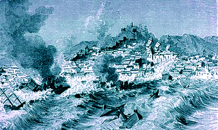
The destruction caused by the earthquake was beyond description.
Lisbon's great cathedrals, Basilica de Santa Maria, Sao Vincente
de Fora, Sao Paulo, Santa Catarina, the Misericordia - all full
of worshipers - collapsed, killing thousands. Lisbon's whole
quay and the marble-built Cais De Pedra along the Tagus disappeared
into the river, burying with it hundreds of people who had sought
refuge.
 Earthquake Effects Widely Felt
The Lisbon earthquake
caused considerable damage not only in Portugal but in Spain
- particularly in Madrid and Seville. The shock waves were felt
throughout Europe and North Africa, over an area of about 1,300,000
square miles.
In Europe, ground
motions were felt in Spain, France, Italy, Switzerland, Germany,
and as far away as the Duchy of Luxembourg and Sweden. Unusual
phenomena were observed at great distances. For example, seiches
were observed in Finland. In Italy, an ongoing volcanic eruption
of Vesuvius stopped abruptly.
Precursory phenomena
also had been widely observed prior to the great earthquake.
For example in Spain, there had been reports of falling water
levels. Turbid waters and a decrease in water flow in springs
and fountains had been reported in both Portugal and Spain.
In North Africa the
quake caused heavy loss of life in towns of Algeria and Morocco
- more than 400 miles south of Lisbon. The town of Algiers was
completely destroyed. Tangiers suffered great loss of lives and
extensive damage. The earthquake was particularly destructive
in Morocco, where approximately 10,000 people lost their lives. Archival records document
that the coastal towns of Rabat, Larache, Asilah, and Agadir
(named Santa Cruz while under Portuguese rule) suffered much
damage. Even the interior cities of Fez, Meknes and Marrakesh
were similarly damaged. In Meknes, numerous casualties occurred.
Churches, mosques and many other buildings collapsed.
The
Great Lisbon Fire
 Whatever the earthquake shocks and the tsunami
waves spared from destruction, a great fire - which started soon
thereafter - finished.
Whatever the earthquake shocks and the tsunami
waves spared from destruction, a great fire - which started soon
thereafter - finished.
Within minutes the
fire spread and turned Lisbon into a raging inferno. Unable to
run, hundreds of patients in the Hospital Real burned to death.
Remaining survivors ran to the hills and the fields outside the
city.
Fanned by steady northeast
winds, the great fire burned out of control through the ruins
of the city for more than 3 days. It swept everything in its
path and destroyed houses, churches and palaces. Lisbon's magnificent
museums, and its magnificent libraries - housing priceless documents
and papers dealing with the great history of Portugal's great
past - burned to the ground. Archives and other precious documents
were completely destroyed. Works of art, tapestries, books, manuscripts,
including the invaluable records of the India Company were destroyed.
Also burned was the king's palace and its 70,000-volume library.
Over two hundred fine, priceless paintings , including paintings
by Titan, Reubens, and Coreggio, were burned in the palace of
the Marques de Lourcal.
Death
Toll and Destruction from Earthquake, Tsunami and Fire
The earthquake destroyed
Lisbon and other major cities in Portugal. More than 18,000 buildings,
representing about 85% of the total were completely demolished.
In the first two minutes of the earthquake, about 30,000 people
lost their lives. The total death toll in Lisbon, a city of 230,000,
was estimated to be about 90,000. Another 10,000 people were
killed in Morocco.
Significance
of the Great Lisbon Earthquake
The great Lisbon earthquake
of 1755, marked the beginning of the modern era of seismology.
Following this earthquake there were systematic efforts to catalog
the times and locations of earthquakes and to study their physical
effects.
 The Great Lisbon Tsunami of November
1, 1755
The Great Lisbon Tsunami of November
1, 1755
Introduction
 Shortly after the earthquake struck the great
city, a series of huge tsunami waves crashed over the harbor
quays, engulfed the lower part of Lisbon on the shore of the
Tagus, and submerged much of the lower part of the city - including
its newly built, marble quay of Cais De Pedra which disappeared
into the river.
Shortly after the earthquake struck the great
city, a series of huge tsunami waves crashed over the harbor
quays, engulfed the lower part of Lisbon on the shore of the
Tagus, and submerged much of the lower part of the city - including
its newly built, marble quay of Cais De Pedra which disappeared
into the river.
The first three of
these tsunami waves were the largest and completed the destruction
brought about by the two earlier strong quake shocks. 20,000
more of the terrified survivors who had rushed to the open space
of the docks and the waterfront quay for safety, lost their lives
to these tsunami waves. All boats moored in Lisbon's harbor were
destroyed.
Eyewitness Account of the Tsunami
 Rev. Charles Davy was a survivor of this great
Lisbon disaster. The following is an excerpt from his account
describing his observations of the tsunami : (Source of historical depiction: Eva March Tappan,
ed., The World's Story: A History of the World in Story, Song
and Art, 14 Vols., (Boston: Houghton Mifflin, 1914), Vol. V:
Italy, France, Spain, and Portugal, pp. 618-628)
Rev. Charles Davy was a survivor of this great
Lisbon disaster. The following is an excerpt from his account
describing his observations of the tsunami : (Source of historical depiction: Eva March Tappan,
ed., The World's Story: A History of the World in Story, Song
and Art, 14 Vols., (Boston: Houghton Mifflin, 1914), Vol. V:
Italy, France, Spain, and Portugal, pp. 618-628)
"You may judge
of the force of this shock, when I inform you it was so violent
that I could scarce keep on my knees; but it was attended with
some circumstances still more dreadful than the former. On a
sudden I heard a general outcry, "The sea is coming in,
we shall be all lost." Upon this, turning my eyes towards
the river, which in that place is nearly four miles broad, I
could perceive it heaving and swelling in the most unaccountable
manner, as no wind was stirring. In an instant there appeared,
at some small distance, a large body of water, rising as it were
like a mountain. It came on foaming and roaring, and rushed towards
the shore with such impetuosity, that we all immediately ran
for our lives as fast as possible; many were actually swept away,
and the rest above their waist in water at a good distance from
the banks.
For my own part I
had the narrowest escape, and should certainly have been lost,
had I not grasped a large beam that lay on the ground, till the
water returned to its channel, which it did almost at the same
instant, with equal rapidity. As there now appeared at least
as much danger from the sea as the land, and I scarce knew whither
to retire for shelter, I took a sudden resolution of returning
back, with my clothes all dripping, to the area of St. Paul's.
Here I stood some time, and observed the ships tumbling and tossing
about as in a violent storm; some had broken their cables, and
were carried to the other side of the Tagus; others were whirled
around with incredible swiftness; several large boats were turned
keel upwards; and all this without any wind, which seemed the
more astonishing.
It was at the time
of which I am now speaking, that the fine new quay, built entirely
of rough marble, at an immense expense, was entirely swallowed
up, with all the people on it, who had fled thither for safety,
and had reason to think themselves out of danger in such a place:
at the same time, a great number of boats and small vessels,
anchored near it (all likewise full of people, who had retired
thither for the same purpose), were all swallowed up, as in a
whirlpool, and nevermore appeared.
This last dreadful
incident I did not see with my own eyes, as it passed three or
four stones' throws from the spot where I then was; but I had
the account as here given from several masters of ships, who
were anchored within two or three hundred yards of the quay,
and saw the whole catastrophe. One of them in particular informed
me that when the second shock came on, he could perceive the
whole city waving backwards and forwards, like the sea when the
wind first begins to rise; that the agitation of the earth was
so great even under the river, that it threw up his large anchor
from the mooring, which swam, as he termed it, on the surface
of the water: that immediately upon this extraordinary concussion,
the river rose at once near twenty feet, and in a moment subsided;
at which instant he saw the quay, with the whole concourse of
people upon it, sink down, and at the same time every one of
the boats and vessels that were near it was drawn into the cavity,
which he supposed instantly closed upon them, inasmuch as not
the least sign of a wreck was ever seen afterwards.
This account you may
give full credit to, for as to the loss of the vessels, it is
confirmed by everybody; and with regard to the quay, I went myself
a few days after to convince myself of the truth, and could not
find even the ruins of a place where I had taken so many agreeable
walks, as this was the common rendezvous of the factory in the
cool of the evening. I found it all deep water, and in some parts
scarcely to be fathomed."
Tsunami
Effects in the Tagus River Estuary in Lisbon and along the west
and south coasts of Portugal.
For most coastal regions of Portugal, the destructive
effects of the resulting tsunami were more disastrous than those
of the earthquake. The first three of the tsunami waves were
particularly destructive along the west and south coasts of Portugal.
At the mouth of the
Tagus river estuary and upstream , there was an initial recession
of the water which left exposed large stretches of the river
bottom. Shortly afterwards, the first of the tsunami waves arrived.
It swamped Bugie Tower and caused extensive damage to the western
part of Lisbon, the area between Junqueria and Alcantara. The
same wave continued upstream spreading destruction and demolishing
the Cais de Pedra at Terreiro do Paco and part of the nearby
custom house. The maximum wave height at this location was estimated
to be about 6 meters. Boats which were overcrowded with quake
survivors seeking refuge, capsized and sank. There were two more
large waves. It is estimated that the largest tsunami runup in
the Tagus estuary was about 20 meters.
 At the coastal town of Cascais,
about 30 km west of Lisbon, large stretches of the sea floor
were initially exposed, then the arriving tsuinami waves demolished
several boats. At Peniche, a coastal town about 80 km north of
Lisbon, many people were killed by the tsunami. In Setubal, another
coastal town 30 km south of Lisbon, the water reached the first
floor of buildings.
At the coastal town of Cascais,
about 30 km west of Lisbon, large stretches of the sea floor
were initially exposed, then the arriving tsuinami waves demolished
several boats. At Peniche, a coastal town about 80 km north of
Lisbon, many people were killed by the tsunami. In Setubal, another
coastal town 30 km south of Lisbon, the water reached the first
floor of buildings.

The tsunami destruction
was particularly severe in the province of Algarve, in southern
Portugal, where almost all the coastal towns and villages were
severy damaged, except Faro, which was protected by sandy banks.
In some coastal regions of Algarve, the maximum tsunami wave
runup was 30 meters. According to reports, the waves demolished
coastal fortresses and razed houses to the ground. In Lagos,
the waves reached the top of the city walls.
Tsunami
Generating Area 
In 1755, there were no instruments
in existence to record the Lisbon earthquake and thus determine
its epicenter. The epicenter was reported to have been at 38.0°N,
9.0°W. , about 200 km WSW of
Cape St. Vincent. However
the tsunami travel time to Lisbon was approximately 40 minutes,
which suggests that the epicenter and the tsunami generating
area must have been further south and west of the reported location.
Generating Areas of
the 1755 and 1969 tsunamis along the Azores-Gibraltar Fracture
Zone (AGFZ) superimposed on bathymetry and gravity anomaly map
(Source: Pararas-Carayannis, 2001)
Numerical modeling
studies of the small tsunami generated by the February 28, 1969
quake in the same general area of the Atlantic (Heinrich, Batista,
and Miranda, 1994), have suggested that the epicenter of the
Lisbon earthquake was close to that of the 1969 event which produced
only a small tsunami. The epicenter of the 1969 quake was centered
south of Gorringe bank near the Azores-Gibraltar fracture zone
in the Atlantic Ocean (see map). However, the travel time to
Lisbon for the first wave of the 1755 tsunami indicates that
its generating area was somewhat north of the 1969 event. It
took about 40 minutes for the first wave to reach Lisbon in 1755.
The travel time to Lisbon from the 1969 quake was closer to 50
minutes. Also, the first wave in 1755 was negative, which indicates
that the wave originated from a region of subsidence, while the
1969 wave was positive from an area of upthrust.
In the absence of
seismological source parameters for the 1755 Lisbon quake, Dr.
Charles Mader used the reported Lisbon tsunami wave characteristics
to estimate source dimensions and tsunami travel times (personal communication March 2001, see also
reference below). Since
the initial tsunami wave was a drop of about 20 meters in Lisbon
and the observed period was about 1 hour, he postulated that
the tsunami generating area was fairly wide, involving considerable
ocean floor subsidence. He estimated that a tsunami source region
of about 300 kilometers in radius (282,000 square kilometers),
dropping about 30 meters, could generate the type of wave which
occurred in Lisbon.
As presented earlier,
the epicenter of the the 1755 Lisbon earthquake could not have
been at 38 N, 9 W, as postulated because there is no significant
tectonic interaction at this location. More likely the quake's
epicenter and the tsunami generating area were further south
and west. A more probable tsunami generating area - where subsidence
is possible - would have been north of the Gorringe Bank along
the Azores- Gilbratar fracture zone (AGFZ), rather than south
where the 1969 tsunami was generated (and as postulated by Heinrich,
Batista, and Miranda (1994)).
AGFZ marks the boundary
of active continent to continent convergence between the African
and the Eurasian plates. Compression along this boundary appears
to result in an echelon overlapping and staggering arrangement
of a series of faults, some being thrust or reverse types with
the net result being a wide distribution of grabbens and horsts.
These oceanic features have resulted from subsidence or upward
displacements of crustal blocks. Each of these features is relatively
short, but collectively they form the wide linear zone, known
as the AGFZ, in which the strike of the individual features is
oblique to that of the zone as a whole.
The AGFZ is an active
seismic region where large earthquakes can occur with frequency.
Some of the larger earthquakes, particularly those occurring
closer to the eastern section of AGFZ are capable of generating
tsunamis. The tectonic interaction on the eastern segment involves
a thrusting component in NW direction. However, because of differences
in source parameters and mechanisms of continent to continent
compression (and possibly triple junction interaction with the
Atlantic oceanic plate), each earthquake in this region, regardless
of magnitude, will not have the same efficiency for tsunami generation.
This is the reason why the 1969 quake generated a small tsunami,
even though it had a rather large magnitude , Ms=7.9, and involved
thrust faulting. It is believed that the tsunamigenic efficiency
of the 1755 Lisbon earthquake was greater because of large scale
subsidence caused by continent to continent convergence and compression.
The generating area was in the abyssal plain, north of the Gorringe
Bank along the Azores- Gilbratar fracture zone (AGFZ), a region
characterized also by negative gravity anomalies.
Tsunami
Travel Times and Heights
About 30 minutes after the earthquake struck
Lisbon, the sea level near the Bugie Tower at the mouth of the
Tagus river, begun to recede. About 10 minutes later the first
large wave arrived, so the tsunami travel time from the source
region to Lisbon was approximately 40 minutes. It took less than
an hour for this first tsunami to reach Morocco and Algiers,
and about 7 hours to reach the Caribbean and the U. S. East coast.
Atlantic-Wide
Tsunami Effects
Remarkable tsunami
waves and effects were recorded and reported everywhere, on both
sides of the Atlantic. Waves up to 60 feet in height
hit a vast area stretching from Finland to North Africa and across
the Atlantic to Martinique and Barbados causing much destruction
and loss of life. Lakes as far north as Sweden were affected
as well as the river Dal in Norway, 1800 miles (about 2,890 kilometers)
away, which overflowed its banks.
Spain: In southwestern Spain, the tsunami
caused damage to Cadiz and Huelva, and the waves penetrated the
Guadalquivir River, reaching Seville.
Gibraltar: In Gibraltar, the sea rose suddenly
by about two meters. In Ceuta the tsunami was strong,
Mediterranean Sea: in the Mediterranean Sea,
it decreased rapidly.
Morocco: Caused
great damage and casualties to the western coast of Morocco,
from Tangier, where the waves reached the walled fortifications
of the town, to Agadir, where the waters passed over the walls,
killing many.
France Great Britain,
Ireland, Belgium and Holland: The tsunami reached, with less intensity, the coast of France,
Great Britain, Ireland, Belgium and Holland.
Madeira and the Azores
islands: Madeira
and in the Azores islandsdamage was extensive and many ships
were in danger of being wrecked.
Antilles, Antigua,
Martinique, and Barbados: The
tsunami crossed the Atlantic Ocean, reaching the Antilles in
the afternoon. Reports from Antigua, Martinique, and Barbados
note that the sea first rose more than a meter, followed by large
waves.
 Numerical Modeling
Studies of Tsunami Travel Times and Heights
Numerical Modeling
Studies of Tsunami Travel Times and Heights
Using the postulated
tsunami source parameters {300 kilometers radius (282,000 square
kilometers), and about 30 meters of subsidence} Dr. Mader' numerical
modeling study provided estimates of the tsunami travel time
and the deep water tsunami wave amplitudes along the east coast
of USA, in the Caribbean and the Gulf of Mexico.
Travel Time Chart of
the Great Lisbon Tsunami (Source: Dr. Charles Mader)
Based on this computer
simulation, he estimated that the offshore deep water tsunami
amplitudes along the USA coast and the Caribbean must have been
about 2 meters high with periods of 1.25 to 1.5 hours. The maximum
tsunami runup on the shore would have been about 10 feet (about
3 meters). In the Gulf of Mexico the offshore tsunami deep water
amplitudes would have been less than a meter.
Conclusions
The deep water, tsunami height estimates for
the U.S. East Coast, the Caribbean and the Gulf of Mexico seem
reasonable. Actual tsunami runup on the shore would have been
higher depending on the local bathymetry and the coastal configurations.
The Great Lisbon tsunami
of 1755 was most probably generated in the abyssal plain north
of the Gorringe Bank along the Azores-
Gilbratar fracture zone (AGFZ). The bathymetry, gravity anomalies and overall
geomorphological features of the easterrn segment of the AGFZ
indicate the existence of a large area of subsidence, characterized
by a grabben with an approximate orientation of N45E caused by
continent to continent collision.
The eastern section
of AGFZ is an area of active tectonic interaction, capable of
producing large earthquakes with variable tsunamigenic efficiencies.
Although the Lisbon earthquake of 1755 was a rare and unusual
combination of seismic and tsunami events, a recurrence in the
future is a certainty. However, in the absence of adequate historical
earthquake data, it is not possible to provide a statistical
probability as to when an event similar to the Great Lisbon Earthquake
and Tsunami of 1755 may reccur.
REFERENCES
Heck, N.H.,1947, List
of seismic sea waves, Bull.
Seismol. Soc. Am., v. 37, no. 4, p. 269-284.
Mader, Charles, 2001, Modeling the 1755 Lisbon Tsunami, Mader Consulting Co., Honolulu,
Hawaii, u.S.A.
Milne, J. 1912, Catalog of destructive earthquakes, Brit. Assn. Adv.
Sci. Rept. 81st Mtg., 1911, p. 649-740.
Myles, Douglas, 1985, "The Great Waves"
- Tsunami, Foreword by G. Pararas-Carayannis,
206pp, McGraw Hill, 1885.
Myles, Douglas, 1986, "The
Great Waves" - Tsunami, Foreword
by G. Pararas-Carayannis, 206pp, Robert Hale Ltd, London, 1986.
Pararas-Carayannis, George, 2001, The Potential for
Tsunami Generation along the Azores-Gibraltar Fracture Zone, (unpublished paper).
Pararas-Carayannis, George, 2001,Tsunamigenic Efficiency, (Unpublished Paper).
Svyatlowski, A.E.,
1957. Tsunamis--destructive waves originating with
underwater earthquakes in seas and oceans [Russian], Izdatel'stvo
Akad. Nauk SSSR, p. 1-69, Eng. transl. by V. Stevenson, Hawaii
Inst. Geophys., Transl. Ser. 8, 1961.
Kozak, Jan T., and James D. Charles,
Paper abridged and edited from drafts of a longer work in progress
by V. S. Moreira, C. Nunes and J. Kozak on the Lisbon Earthquake of 1755. Institue of Rock Mechanics, Czech Academy of
Science , National Information Service for Earthquake Engineering
(NISEE) of the University of California, Berkeley,
Tappan March Eva,
ed., 1914. The World's
Story: A History of the World in Story, Song and Art, 14
Vols., (Boston: Houghton Mifflin, 1914), Vol. V: Italy, France,
Spain, and Portugal, Source: Modern History Sourcebook: Historical Depictions of the
1755 Lisbon Earthquake Rev. Charles Davy: The Earthquake at Lisbon, 1755, pp. 618-628.
Some of the images
presented here have been modified from the Kozak Collection of
Images of Historical Earthquakes, National Information Service
for Earthquake Engineering (NISEE) of the University of California,
Berkeley, from the Lisbon Museum and from unpublished work of
Dr. Charles Mader (permission granted).