|
The
November 4,1952 Kamchatka Earthquake and Tsunami
George Pararas-Carayannis

(Excerpts
from the archives to the Catalogs of Tsunami in the Hawaiian
Islands. World Data Center A- Tsunami U.S. Dept. of Commerce
Environmental Science Service Administration Coast and Geodetic
Survey, May 1969)

Introduction
 On November 4, 1952, at 16:52 GMT, a strong earthquake
off the coast of Kamchatka Peninsula, in the far east of Russia,
gnerated a great destructive Pacific-wide tsunami. The tsunami
waves struck the Kamchatka Peninsula, the Kuril Islands and other
areas of Russia's Far East, and caused considerable damage and
loss of life. The tsunami caused severe damage along the Pacific
coastal area of the Kamchatka Peninsula, and was also very damaging
in the Hawaiian Islands. There was also some damage in Peru and
Chile. Although the tsunami was widely observed and recorded
in Japan, there was no loss of life or any significant damage
there. On November 4, 1952, at 16:52 GMT, a strong earthquake
off the coast of Kamchatka Peninsula, in the far east of Russia,
gnerated a great destructive Pacific-wide tsunami. The tsunami
waves struck the Kamchatka Peninsula, the Kuril Islands and other
areas of Russia's Far East, and caused considerable damage and
loss of life. The tsunami caused severe damage along the Pacific
coastal area of the Kamchatka Peninsula, and was also very damaging
in the Hawaiian Islands. There was also some damage in Peru and
Chile. Although the tsunami was widely observed and recorded
in Japan, there was no loss of life or any significant damage
there.
The Earthquake
The destructive tsunami
was triggered by an earthquake, which had a surface-wave magnitude
of 8.2 and a focal depth of 30 km. The quake's epicenter was
at 52.8° N, 159.5° E. Some years later a Moment Magnitude
(Mm) of 9.0 was assigned to this quake
 Tectonic Setting Tectonic Setting
The Kamchatka Peninsula
is the site of shallow subduction of the Hawaii-Emperor seamount
chain, one of world's longest (6000 km) hotspot chains.
The geologic and geophysical
data that has been collected over the years for this region of
the Kamchatka Peninsula indicates that shallow plate subduction
and/or accretion of seamounts may be responsible for several
of the regional tectonic effects, including the formation or
a double Neogene volcanic arc separated by an intra-arc basin.
Geochemical, structural
and stratigraphic data shows the presence of alkaline volcanic
rocks in the outer volcanic arc and an active forearc indentation
of the Pacific margin of Kamchatka, associated with constriction
and shoaling of the Kamchatka trench, and uplift of marine forearc
basins of Neogene age.
Shallow subduction
and accretion of seamounts is particularly evident in the forearc
region of the Kronotskiy Peninsula - the Pacific promontory near
which the Hawaii-Emperor seamount hotspot chain terminates. The
November 4, 1952 earthquake occurred in this general area.
The Tsunami
Near the Area of Generation
The highest and most
destructive waves from this tsunami were observed and experienced
in the Kamchatka Peninsula, the Kuril Islands and other areas
of Russia's Far East. There was considerable damage and loss
of life in these areas. The 2nd and 3rd waves were the highest.
Kamchatka - Russia
 From
Kamchatka Peninsula to Kronotsky Peninsula: Tsunami wave heights ranged from zero to 5 meters. From
Kamchatka Peninsula to Kronotsky Peninsula: Tsunami wave heights ranged from zero to 5 meters.
From Kronotsky Peninsula
to Cape Shipursky: Tsunami
wave heights ranged from 4-13 meters with the highest wave of
13 meters observed at Olga Bay. The 3rd wave was the highest.
Travel time of the first tsunami wave to Olga Bay was approximately
42 minutes after the earthquake. There was considerable damage.
From Cape Shipursky
to Cape Povorotny: The
waves ranged from 1 to 10 meters and considerable loss of life
and damage were reported. At Avachinskaia Bay the tsunami height
was 1.2 meters and tsunami travel time was about 30 minutes.
From Cape Povorotny
to Cape Lopatkka: The
tsunami waves ranged from 5 to 15 meters. At Khodutka Bay a cutter
was thrown 500 meters back from shore
At West coast - Ozernoe: Tsunami run up was 5 meters
 Kuril Islands Kuril Islands
At Alaid Island run up was 1.5 meters, at Shumshu Island
it ranged from 7-9 meters. At Paramushir
Island the waves
ranged from 4-18.4 meters. At Severo
- Kurilsk on Paramushir
Island the second wave was the highest reaching maximum run up
of 15 meters. It destroyed most of the town and caused considerable
loss of life.
At Onekotan Island
tsunami run up was 9 meters, while at Shiashkoton Island 8 meters and at Iturup Island
2.5 meters.
Komandorsk Islands and
at Okhotsk - Magadan
waves of up to 2 meters were observed.
At Sakhalin - At Korsakov a 1 meter wave
was observed.
Japan
The
tsunami was widely observed and recorded in Japan but there was
no loss of life or damage. The following are locations in Japan
where the tsunami was observed or recorded. The height is given
in meters. Travel times ranged from 1.8 hours at Kushiro to 4.6
hours at Kii- Kushimoto.
Hokkaido (Kushiro
= Hokodate 0.5 m)
Sanriku (Kuji,1.0,
Ishinomaki 0.9 m)
Kii - (Kushimoto 0.8 m)
Tsunami Effects
in the Hawaiian Islands
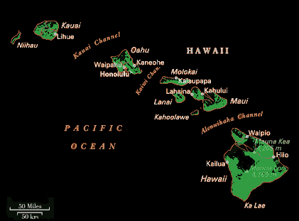
The
Hawaiian Islands experienced larger waves than most places outside
the generating area.
The tsunami caused
damage on Midway Island. Elsewhere in the Hawaiian island chain,
the tsunami waves were destructive in certain locations but hardly
noticeable at others. In some locations, the waves destroyed
boats and piers, knocked down telephone lines, and caused extensive
beach erosion. Fortunately, no human lives were lost in Hawaii
from this tsunami, but damage was extensive, estimates ranging
from $800,000- $1,000,000 (in1952 dollars).
Midway Island: This is an island of low elevation
about 3,000 km away from the generating area, and it is part
of the Hawaiian Island group. Tsunami waves of 1 meter flooded
the streets and buildings on Midway. 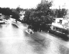 Travel time was 4.4 hours. The period of the
waves was 12 minutes. Damage at Midway Island was estimated at
$ 0.8 to $1.0 million (1952 dollars) Travel time was 4.4 hours. The period of the
waves was 12 minutes. Damage at Midway Island was estimated at
$ 0.8 to $1.0 million (1952 dollars)
Flooding
at Midway Island from the 1952 Tsunami (U.S. Navy Photograph)
Kauai
- There was damage on the
north shore of the island but it was not significant.
Oahu
-The north shore of Oahu
experienced higher waves of up to 4.5 meters. The Honolulu tide
gauge recorded only .7 meter wave. However as the photo below
indicates, actual tsunami run up was higher. The tsunami was
powerful enough to throw a cement barge in the Honolulu Harbor
into a freighter. Tsunami Travel Time to Honolulu was 6.3 hours.Periods
of waves averaged 38 minutes.
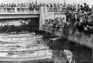 Photo of people gathered
at the Ala Wai Boat Harbor in Honolulu watching the withdrawal
of the water that left boats sitting on harbor mud - An example
of very foolish thing to do during a tsunami. These people should
have been evacuated long before the arrival of the tsunami. Photo of people gathered
at the Ala Wai Boat Harbor in Honolulu watching the withdrawal
of the water that left boats sitting on harbor mud - An example
of very foolish thing to do during a tsunami. These people should
have been evacuated long before the arrival of the tsunami.
Maui - No significant wave was reported
from Kahului
Hawaii - The island of Hawaii experienced
run up to 6.1 meters.
Coconut Island, Hilo
Bay: Run up at Hilo
was 3.7 meters. A small bridge connecting Coconut Island to the
shore was destroyed by one of the tsunami waves lifting it off
its foundation, then smashing it down. Tsunami Travel Time to
Hilo was 6.6 hours. Damage at Hilo was estimated at $ 0.4 million
(1952 dollars).
By far the largest waves
outside the generating area were observed in the Hawaiian Islands.
Fortunately, no human lives were lost in Hawaii from this tsunami,
but damage was extensive, estimates ranging from $800,000- $1,000,000
(in 1952 dollars). The tsunami caused damage on Midway Island.
Elsewhere in the Hawaiian island chain, the waves destroyed boats
and piers, knocked down telephone lines, and caused extensive
beach erosion. In some locations, tsunami waves were destructive
in certain locations but hardly noticeable at others. The north
shore of Oahu experienced higher waves of up to 4.5 meters. On
the south shore of the island, the tsunami was powerful enough
to throw a cement barge in the Honolulu Harbor into a freighter.
The island of Hawaii experienced run up to 6.1 meters. A small
bridge connecting Coconut Island to the shore was destroyed by
one of the tsunami waves lifting it off its foundation, then
smashing it down.
Tsunami Waves
Recorded or Observed throughout the Pacific
The tsunami was recorded
or observed throughout the islands of the Pacific, in New Zealand
(1m), in Alaska and the Aleutian Islands and in California where
waves of up to 1.4 meters were observed or recorded.
Elsewhere
in the Pacific the tsunami was recorded at the following locations
(tsunami heights given in meters)
Mariannas
Is. Guam - Apra,(0.1)
Palau
Is.
- Yap (0.1)
Caroline
Is. - Truk (0.1)
Wake
I. - (0.3)
Marshall
Is. - Kwajelein (0.3) Eniwetok (0.2)
Phoenix
Is. - Canton I. (0.1)
Samoa
Is.
- Pago Pago (1.0) Apia
(0.1)
New
Zealand
- (appr. 1 meter)
Aleutian
Is. - Attu
- Massacre Bay (1.5); Adak - Sweeper Cove (1.1) ; Unalaska -
Dutch Harbor (0.6)
Alaska
Kodiak
- Womens Bay (0.4); Yakutat (0.3); Juneau (0.2); Sitka(0.3); Seward (0.2)
Canada
- Tofino (0.3); Victoria (0.2)
Washington - Neah Bay (0.2)
California - Travel time to California ranged
from 8.0 hours to Crescent City to 9.6 hours to San Diego. Wave
periods ranged from 12 to 20 minutes.Waves up to 1.4 meters were
observed or recorded as follows: Crescent City (1.1); San Francisco (0.6); Avila (1.0); Port Hueneme (0.7); Los Angeles (0.7); San Diego (0.4)
Mexico - Acapulco (0.5) Travel time 12..6
hours; Salina Cruz (0.6)
Guatemala - San Jose (0.3)
El
Salvador
- La Libertad (0.2)
Nicaragua - San Juan del
Sur (0.2)
Costa
Rica
- Puntarenas (0.4)
Panama - Puerto Armuelles
(0.2)
Ecuador
- La
Libertad (0.2)
Peru
- Callao
(1.0 )
Chile
- Arica (1.2); Valparaiso (0.9); Tulcahuano (1.8)
REFERENCES
Pararas-Carayannis,
George. Catalog of
Tsunamis in the Hawaiian Islands. Data Report Hawaii Inst.Geophys. Jan. 1968
Pararas-Carayannis,
George. Catalog of
Tsunamis in the Hawaiian Islands. World Data Center A- Tsunami U.S. Dept. of
Commerce Environmental Science Service Administration Coast and
Geodetic Survey, May 1969.
Pararas-Carayannis,
George and Calebaugh P.J., Catalog
of Tsunamis in Hawaii, Revised and Updated , World Data Center A for Solid Earth Geophysics,
NOAA, 78 p., March 1977.
Iida, K., D.C. Cox,
and Pararas--Carayannis, George. Preliminary Catalog of Tsunamis Occurring in
the Pacific Ocean.
Data Report No. 5. Honolulu: Hawaii Inst.Geophys.Aug. 1967.
IIDA, K., D.C. Cox,
and G. Pararas-Carayannis, 1967b.
Bibliography to the
Preliminary Catalog of Tsunamis Occurring in the Pacific Ocean, Hawaii Inst. Geophys. Data Rpt.
6, HIG-67-25, Univ. of Hawaii, 27 pp.
Additional References
Anon., 1952a
Seismological notes,
Bull. Seismol. Soc.
Am., v. 42, no. 2, p. 204-205, 273
Anon. ,
1952b.Tsunami of March
3, 1952 in Hawaii,
Volcano Letter , Hawaiian Volc. Obs., No. 515, p. 7.
Anon., 1953. Investigation of mareograms of tsunami accompanying
Kamchatka earthquake,
Quart. J. Seismol., v. 18, no. 1, p. 38-39.
Anon., 1954a. Seismological
notes, Bull. Seismol.
Soc. Am., v. 44, no. 1, p. 86.
Anon., 1954b. Outline of Earthquake Disasters in and near Japan, v. 1, 1886-1912, [Japanese], Earth.
Information Group, Seismol. Section, Central Meteorol. Obs.
Berninghausen, W.H.,
1962. Tsunamis reported from the west coast of South
America,1562-1960,
Bull. Seismol. Soc. Am., v. 52, no. 4, p. 915-921.
Cox, D. C., and J. F.
Mink, 1963. The tsunami of 23 May 1960 in the Hawaiian Islands, Bull. Seismol. Soc. Am., vol.
53, no. 6, p. 1191-1209.
Hatori, T., 1963a. On the
tsunamis along the island of Hawaii, Bull. Earthq. Res. Inst., v. 41, p. 49-59.
Hatori, T., 1963b. Directivity of Tsunamis, Bull. Earth. . Res. Inst., v.
41, p. 61-81.
Iida, K., 1958. Magnitude
and energy of earthquakes accompanied by tsunamis, and tsunami
energy, J. Earth Sci.,
v. 6, no. 2, p. 101-11
Iida, K., 1963a. A relation
of earthquake energy to tsunami energy and the estimation of
the vertical displacement in a tsunami source, J. Earth, Sci., v. 2, no. 1, p. 49-67.
Iida, K., 1963b. Magnitude
of tsunamigenic earthquake after shock area, and area of tsunami
origin, Geophys. Papers
Dedicated to Prof. .K. Sassa, [Kyoto Univ.], p. 115-124
Iida, K., D.C. Cox,
and Pararas--Carayannis, George. Preliminary Catalog of Tsunamis Occurring in the
Pacific Ocean. Data
Report No. 5. Honolulu: Hawaii Inst.Geophys.Aug. 1967.
Iida, K., D.C. Cox, and Pararas-Carayannis, George. Bibliography to the Preliminary
Catalog of Tsunamis Occurring in the Pacific Ocean. Data Report No. 6. Honolulu:
Hawaii Inst. Geophys., Dec 1967.
Keys, J. G., 1957. History of Tsunamis in Samoa, Apia Obs ., Samoa, 6 pp.
Macdonald , G. A. and
C. K.Wentworth, 1954. The tsunami of Nov. 4, 1952 on
the island of Hawaii,
Bull. Seismol. Soc. Am., v. 44, no. 3, p. 463-469.
Murphy L.,and W. Cloud,
1954. U. S. Earthquakes, 1952, U. S. Dept. of Comm., Coast & Geod. Survey,
Washington, D. C., Ser. 773, p. 1-112.
Sviatlovsky, A.E.M1957.
Tsunamis--destructive
waves originating with underwater earthquakes in seas and oceans
[Russian], Izdatel'stvo Akad. Nauk SSSR, p. 1-69, Eng. transl.
by V. Stevenson, Hawaii Inst. Geophys., Transl. Ser. 8, 1961.
Solov'ev, S.L. and M.
D. Ferchev, 1961. Summary
of data on tsunamis in the USSR [Russian], Bull. Counc. Seismol.,
v. 9, p. 1-37, Eng. transl. by W. G. Van Campen, Hawaii Inst.
Geophys., Transl. Ser. 9, 1961.
Watanabe, H.M 1956. Studies on the tsunamis on the
Pacific Coast of Northern Japan, Geophys. flag., Tokyo v. 27,
no. 1, p. 61-75.
Zerbe, W. B., 1953. The
tsunami of Nov. 4, 1952, as recorded at tide stations, U. S.
Dept. of Comm., Coast & Geod. Survey, Washington, D. C.,
Spec. Publ. 300, 62 pp.
RETURN TO

Links
to other Pages
 NEW BOOK - THE
BIG ONE- The Next Great California Earthquake
NEW BOOK - THE
BIG ONE- The Next Great California Earthquake
 now available from
Amazon, Barnes and Noble and other major bookstores. It can be
also ordered by contacting directly Aston
Forbes Press.
now available from
Amazon, Barnes and Noble and other major bookstores. It can be
also ordered by contacting directly Aston
Forbes Press.

OTHER MISCELLANEOUS NON-TECHNICAL WRITINGS


|