|
THE
SOURCE MECHANISM OF THE EARTHQUAKE AND TSUNAMI OF OCTOBER 17,
1966 IN PERU
George Pararas-Carayannis

The Earthquake
and Tsunami of 17 October 1966 in Peru.
 The Earthquake: A
strong earthquake of 7.5 magnitude on the Richter scale occurred
east of the Peru Trench axis at 21:42 (Greenwich Time) on October
17, 1966. The epicenter of this quake was at 10.7 S Latitude
and 78.7 W Longitude off the coast of Pativilca of Central Peru,
190 Km northwest of Lima (U. S. C & GS, 1966.) Its focal
depth was 60 Km . The Earthquake: A
strong earthquake of 7.5 magnitude on the Richter scale occurred
east of the Peru Trench axis at 21:42 (Greenwich Time) on October
17, 1966. The epicenter of this quake was at 10.7 S Latitude
and 78.7 W Longitude off the coast of Pativilca of Central Peru,
190 Km northwest of Lima (U. S. C & GS, 1966.) Its focal
depth was 60 Km .
Earthquake Effects: The earthquake affected a coastal belt 400 Km
long and less than 50 Km wide, and severely damaged the towns
of Huacho, Huaura, Puente Piedra and sectors of Lima-Callao.
The highest intensity was observed in the vicinity of Huaura
and may be related to a fault between Upper Jurassic and Lower
Cretaceous sediments. (Lommitz and Cabre', 1968.) Effects of
high intensity were also observed near the outlets of rivers
and other areas of recent alluvium deposits.
The tsunami: The quake generated a large tsunami which caused
destruction along the Peruvian coast from Chimbote in the North
to San Juan in the South. (Pararas-Carayannis, 1968). The greatest
wave at Callao had a range of 3.40 m height (range between maximum
crest and trough) and tsunami waves exceeding 3 meters in amplitude
(height above undisturbed water level) inundated La Punta, Chuito,
Ancon, Huaura, Huacho, and the resort of Buenos Aires in the
City of Trujillo.
Tsunami Effects in the
Immediate Area: Within 60-70 minutes after the
quake, tsunami waves arrived at the cities of Chimbote and San
Juan, which are about 800 Km apart. Devastating effects were
experienced at Casma and Calota Tortuga where waves exceeding
6 meters in range destroyed many structures. (Pararas-Carayannis,
1968).
The port of Casma, about
360 Km north of Lima, suffered the greatest damage. Losses were
estimated at about $4 million (40 million Soles). Many fish-flour
factories and the harbor wharf were severely damaged. Tsunami
destruction also occurred at Puerto Chimu and Culebras (El Commercio
de Lima, Peru, 18, 19 October 1966).
The tsunami caused no
damage outside Peru, but was recorded by tide gauges throughout
the Pacific Ocean. (Beckman and Carrier, 1967).

 Tectonic Setting of
the Central and Northern Peru Region Tectonic Setting of
the Central and Northern Peru Region
The Peru-Chile Trench
- also known as the Atacama Trench - is the active boundary of
collision of the Nazca Plate with the South American Plate. Subduction
of the Nazca plate beneath the South America continent is not
homogeneous. As a resut , asperities and structural complications
have caused segmentation along the entire margin, resulting in
zones with different rates of slip, seismic activity, volcanism,
uplift, terracing and orogenic processess. Different sections
of the margin along the Great Peru-Chile Trench, are segmented
by great fractures. Each segment has its own characteristic parameters
of collision and structural geometry and, thus, different potential
for large earthquakes and destructive tsunamis. The structure of the subducting
oceanic Nazca plate is complex (Pedoja et al. 2003). According
to Le Pichon et al. (1973), the velocity of subduction of the
Nazca plate near the south Chile and north Peru region is about
8.7 - 8.8 cm/y.
Seismicity
of the Central and Northern Peru Region
The historical record
supports that the rate of subduction is not uniform and there
is significant fragmentation along the entire length of the margin
as well as differential uplift of the continental block. Certain
tectonic block segments along the Peru-Chile tectonic boundary
have the capability to generate very large earthquakes. In recent
times, large earthquakes in regions of high rate of subduction
have resulted in uplifting and terracing sections of the South
American coast by as much as a few meters. Marine terraces and
evidence of tectonic segmentation is also evident along the entire
North Peruvian and Ecuadorian active margin. The ongoing process
is responsible for the active orogenesis that is taking place
and has created the young Andean mountain range.
Strong, destructive
earthquakes and active orogenesis are evident off Northern/Central
Peru between the Mendana Fracture Zone (MFZ) and the Nazca Ridge.
Even though the Nazca Plate appears to be subducting smoothly
and continuously at about 7-9 cm/yr into the Peru-Chile trench
in this region of Northern/Central Peru, the deeper parts of
the subducting plate appear to break into smaller pieces that
become locked in place for long periods of time before generating
large earthquakes.
Past
Earthquakes and Tsunamis in the in the Central/Northern Peru
Region
The region (from 7.5
to 12.5 degrees South latitude) has produced at least seven destructive
earthquakes in the vicinity of Chimbote and Lima-Callao. These
occurred on: 9 July 1586; 13 November 1655; 20 October 1687;
28 October 1746; 30 March 1828; 24 May 1940 (M = 8.4); and 17
October 1966 (M = 7.5) (Pararas-Carayannis, 1974). Of these,
the earthquakes of 1586, 1687, 1746, 1828 and 1966 are documented
to have produced destructive tsunamis (lida el al., 1968, Pararas-Carayannis,
1974).
1586, 9 July - 0 30 Reconstructed Epicenter
- 12.20 South 77.70 West, Off Lima/Callao, Peru. Reconstructed
Magnitude 8.5 3.5 4.0 26.00 5 L 20 T 4 Destructive Tsunami. The
shore inundated for 10 km inland. Tsunami Height at Trujillo
26 meters.
1655, 13 November
- 19 38 Reconstructed
Epicenter 12.00 South, 77.00 West, Off Lima/Callao. No details.
1678, 17 June - No details. At Santa sea receded
and later returned with destructive violence. Ship carried far
inland (alternate date given January 18)
1687, 10 20 - 9 30 Reconstructed Epicenter
13.50 South, 76.50 West, Magnitude 8.5 3.5 1.0 8.00 14 M 5000
T 4 SAM LOC Off Callao. At Callao and Chancai Pisco, the sea
retreated then returned with great violonce. Town and market
were destroyed. No other details.
1746, 10 29 - 3 30 Reconstructed Epicenter
12.50 South, 77.00 West, Magnitude 8.0 3.5 4.6 24.00 7 L 18000
T 4
Near Callao the tsunami
height was 24 meters. Portion of the coast sank producing a bay.
All ships in the harbor were destroyed or beached. One ship stranded
about 1.5 km inland. Of 5,000 inhabitants only 200 survived.
At Cavallos, Chancay and Gaura the effects of the tsunami were
similar.
1828 3 30 - 12 35 Reconstructed Epicenter
12.10 South, 77.80 West 50 8.2 No details available. Only that
the tsunami was destructive to cities north of Lima (Callao).
1940 5 24 - 16 33 Epicenter 10.50 South,
77.00 West 60 8.4 7.8 1.5 1.0 2.00 1 S 250 T 3 No details available
1942 August 24 - Epicenter 15 South 76 West,
Magnitude 8.1 Shallow. Tsunami at Callao - 1.6meter wave with
period of 30 min. Travel time to Callao 0.7 hour; At Matarani
0.5 meters, Travel Time 1.7 hour. Tsunami wave period 21 min.
DISCUSSION
Source Mechanism
of the Earthquake and Tsunami of 17 October 1966

Earthquake Energy Release:
The 1966 earthquake
occurred along one of three distinct seismic zones in the Peruvian
upper mantle (Ocola, 1966, Pararas-Carayannis, 1974). The activity
of this zone is most pronounced on the western side, and lies
between the Andean mountain block and the Peru-Chile Trench.
This narrow seismic band (100 to 150 km wide) is under Peru's
Continental Shelf and is characterized by shallow earthquake
activity and has great tsunamigenic potential (Pararas-Carayannis,
1968, 1974).
Fig. 1 Energy release
earthquakes off Central Peru for the period 1949 - July 1963.
(Modified after Ocola, 1966). E, epicenter of earthquake of October
17, 1966.
The seismicity of
this particular region can be expressed taking into account ,
not only the number of recorded past events but also their size,
frequency, and spatial distribution (Pararas-Carayannis, 1974).
For example, Ocola (1966) processed all earthquakes which occurred
in the area during a 14 1/2-year period and prepared an earthquake
energy release map which illustrates quite well the seismicity
of this particular region. This map was prepared using the empirical
relationships of earthquake energy, magnitude, and frequency,
derived by Gutenberg and Richter (1956), by plotting the energy
release of equivalent earthquakes of magnitude 4 (Richter scale).
The figure provided here is a section from Ocola's map showing
the earthquake energy release off the coast of central Peru from
January 1949 to July 1963. The energy density contours are in
units of 10 raised to the 19th power of ergs per 1 degree of
latitude by 1 degree of longitude, for the 14 1/2-year period.
The 1966 earthquake occurred within the band of highest activity
shown in this figure.
Although this map
was prepared more than 40 years ago, and for a relatively short
time interval, earthquake events which have occurred since -
including the February 21, 1996 event - do not show significant
change in the seismicity pattern in this region of Central and
Northern Peru.
The orientation of
the contours of energy release indicate general trends striking
N30W, and are in agreement with the general trend of the fault
systems, the Andean Mountains, and the alignment of the Peru-Chile
trench in this Central and Northern region of Peru. Specifically,
the Peru-Chile trench in this region is oriented at about N30W
and the northern part of the Andean Mountains are oriented at
about N32W. Similarly, major outcrops of intrusive rocks along
the coast have general orientations at N20W and N55W.
Fault System Orientation: The 1966 earthquake occurred within the band
of highest activity shown in this figure. The orientation of
the contours indicate general trends striking N 30 W', and are
in agreement with the general trend of the fault systems, the
Andean Mountains, and the Peru -Chile Trench. The Peru-Chile
Trench in this region is oriented at about N 30 W, and the northern
part of the Andean Mountains are oriented at about N 32 W. Similarly,
major outcrops of intrusive rocks along the coast have general
orientations at N 20 W and N 55 W.

Fault and Azimuthal
Orientation of the Tsunamigenic Area.
Fault Plane and Earthquake
Mechanism Solutions
Whether the azimuthal
orientation of the fault system and of the seismotectonic block
responsible for the tsunamigenic earthquake of October 17, 1966
is indeed parallel to the coast and to the Peru-Chile Trench,
can be examined in another way. The nature of the first seismic
motion related to an earthquake depends on the crustal displacement
of the source. A pattern of compressions and rarefactions can
be considered a function of the azimuth to be expected from a
seismic source.
According to a method
developed by Byerly (1955), modal planes of the focus could be
deduced from such recordings of compressions and rarefactions.
According to Nakano (1923), a single force would send compression
waves into a half space and rarefaction waves into the other
half space; a couple would send alternate compressions and rarefactions
into quarter spaces.
It has been established
by Galitzin (1909) that the impulse of P waves indicates a vibration
in a plane containing the great circle that passes through the
epicenter and the station. If the first impulse on the vertical
component of seismograph is up, the first phase of P wave is
a compression, so the composition of north-south and east-west
is in a direction away from the epicenter. A composition of the
three components gives the direction of the first displacement
of the ground, which however is not the exact direction of the
path of the incident wave. It is rather the combination of the
amplitudes of the incident P wave and the reflected P and S waves
that gives an indication of the motion of the surface of the
ground. A projected single straight line on the map, therefore,
indicating the fault, should separate regions where the first
motion was compression from those where it was a rarefaction,
and the strike of the fault and orientation of the tsunamigenic
area can be determined.
The fact that all the
stations in South America, on the continent side of the epicenter
reported an initial compression in their seismographs from the
October 17, 1966 earthquake, indicates that crustal displacements
were indeed along a thrust fault approximately paralleling the
Peruvian coast and that the uplifted position was on the continental
side of the rift.
Lomnitz and Cabre' (1968),
probably because of the sparcity of seismic data, were unable
to determine a focal plane solution for this earthquake, and
could not confirm this parallelism of the fault to the coast.
However, the nature of first water motion observed at stations
near the epicenter and consideration of the tsunami travel path,
as supported by wave refraction in this study, in addition to
the seismic evidence, support the conclusion of a fault orientation
paralleling the coast.
Tsunami Mechanism
Analysis
Ocean Floor Displacements
and Initial Tsunami Height
Crustal Displacement:
Shallow earthquakes,
such as the October 17 1966, have a predominantly lateral strike
slip with a smaller component of vertical dip slip motion. It
is the latter motion that generates tsunamis. Total crustal displacement,
is the resultant of the horizontal strike slip, "X",
and the vertical dip-slip, Z, related by:
D = {X (raised
to 2 nd power) + Z (raised to the 2)} raised to 1/2
Statistical relationships
between maximum crustal displacement and earthquake magnitude
M have been compiled, and working curves have been plotted by
Wilson (1964, 1969). Although such empirically derived curves
display some scatter of data, possibly because of differences
in the focal depth and geology of each region associated with
each seismic event, a median value can be selected as being reasonable
for shallow focus tsunamigenic earthquakes.
Vertical Crustal Displacement
responsible for most of tsunami Energy: For
the October 17, 1966 (M = 7.5), the median value of crustal displacement
along the fault taken from such curve is = 4m. If we assume an
extreme ratio of Strike-slip: Dip-slip of 10:3, then dip-slip,
or vertical movement of the ocean floor along the fault, is calculated
from the equation above to be, Z = 1.15m.
Vertical displacements
of the seismotectonic block responsible for tsunami generation
will decay exponentially with distance normal to the fault in
accordance to the elastic rebound theory of Reid (1910). The
ocean area affected by such displacements, the tsunami generating
area, is an ellipse in which the fault occupies the major axis.
The leading tsunami waves are generated from the periphery of
this area and their arrival at nearby stations is indicative
of the initial ocean floor displacement. Maximum runup on the
shore, is generally caused by the crest of the tsunami wave near
the fault.
Based on the above assumptions
of vertical ocean floor displacements, the initial tsunami height
in the generating area is estimated at a maximum of 1 - 1.1 meters
above the undisturbed sea level.
Shoaling and
Coastal Effects on Tsunami Amplification: Considering
that the waves reaching the immediate coastline had amplitudes
of about 3 meters, the shoaling and resonance amplification factor
on the coast for local tsunamis, for these particular localities,
is estimated to be three times the deep water value. Given, therefore,
the magnitude, depth, and epicenter of an earthquake offshore,
and utilizing the assumptions and empirical relationships outlined
here, the runup along Central Peru from tsunamis originating
from Peru's seismic region 4 can be roughly approximated.
 Fault
Length Fault
Length
Statistical relationships
between fault length L (Km) and earthquake magnitude (M) have
been worked out. Using a statistical relationship developed by
Ambraseys and Zatopek (1968),
Log L = 1.13
M - 6.4
and for a magnitude
of 7.5, a fault length of 118.85 kms is calculated for the October
17, 1966 earthquake. This estimate is in good agreement with
the results of this study.
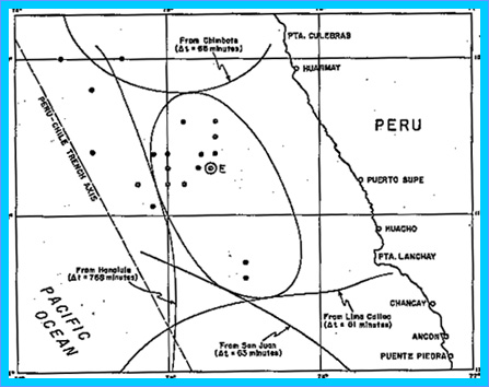
Figure 2. Generating
Area of the October 17, 1966 tsunami in Peru
Tsunami Generating Area.
The tsunami generating
area of the October 17, 1966 earthquake was determined by an
indirect reverse wave refraction method, refracting waves from
Chimbote, Lima-Callao, San Juan, and Honolulu. (Fig. 2). According
to this method, the arrival time of the first tsunami wave at
each of these stations was obtained from the tide gauge record,
and its total travel time was determined.
Tsunami Energy
Table 1. Tsunami
Travel Times. (Date and Time of Quake, October 17, 1966, 21:42
GMT)
PLACE
|
DATE and TIME OF FIRST
WAVE ARRIVAL (GMT)
|
TSUNAMI TRAVEL TIME (MIN)
|
FIRST WATER MOTION
|
Puerto San Juan
|
Oct. 17 22:45
|
63
|
Fall
|
Callao
|
Oct. 17 22:33
|
51
|
Fall
|
Chimbote
|
Oct. 17 22:50
|
68
|
Rise
|
Honolulu
|
Oct. 18 10:30
|
768
|
Fall
|
Tsunami Wave Refraction: Waves were refracted toward
the earthquake area from each station for lengths of time equal
to the tsunami travel time for that station, using the long wave
velocity approximation c = Square root of (gd) , where c is velocity,
g is gravity, and d is depth.
The last wave front
from each refraction diagram ( Figure 1) should correspond to
a point on the boundary of the generating area. An ellipse tangent
to these wave fronts was drawn approximating the tsunami-generating
area. Since no tsunami travel times were available for the coastal
towns near the earthquake epicenter, the shore ward boundary
of the area was approximated based on the symmetry of the ellipse.
Tsunami Energy and Relationship
to Earthquake Potential Energy:
Using this approximation, the tsunami generating area was calculated
to cover about 13,000 sq. Km. Using these source dimensions,
and assuming that the total energy is equal to the potential
energy of the uplifted or depressed volume of water, the total
energy for the tsunami can be approximated by:
E(t) = 1/6 p.g.h(raised
to 2). A=
= 1/6(1.03)(.980)(10
raised to 3)(10 raised to 4)(.55 raised to 2)( 13,000 sq. km)=
6.8 x 10 (raised to the 19) ergs.
Where Et= Total energy
p = 1.03 g/cm = Density
g = 980 cm/sec (raised
to )
h = Assumed average
height of crustal displacement = .55 m
A = Tsunami generating
area = 13,000 Km
1 erg = g cm(raised
to 2) sec (raised to - 2).
Considering
that the energy of the October 17, 1966 earthquake was 1.122
x10 (raised to 23) ergs, the energy responsible for the tsunami
generation is about 1/1,650 of that value.
Summary and Conclusions
The source mechanism
of the tsunami generation associated with the earthquake of 17
October 1966 was indirectly inferred by studying the seismic
and oceanic phenomena associated with this event. The seismic
mechanism was deduced from geologic structure, seismic intensities,
energy releases, spatial distribution of aftershocks, and fault
plane solutions. Using this information and empirical relationships
of seismic parameters, the fault length, azimuthal orientation
of the tsunamigenic area' and initial tsunami height, were obtained.
From the tsunami arrival times at selected stations and from
a reverse wave refraction technique, the limits of the tsunami
generating area were estimated. Using these source dimensions
an estimate of the tsunami energy was obtained. The following
conclusions were reached:
a. The earthquake occurred
in the western part of an active seismic belt that lies between
the Andean mountain block and the Peru-Chile Trench. This seismic
region has been responsible for a number of earthquakes within
recorded history.
b. The energy of the
main ear earthquake was estimated to be 1.12 2 x 10 (raised to
23 rd power) ergs. The energy of the aftershocks was estimated
to be 2.357 x 10 (raised to the 20 th power) ergs.
c. The spatial distribution
of aftershocks associated with the main earthquake correlated
well with known seismotectonic trends and the seismic velocity
structure anomalies which are characteristic of thrust fault
systems at continent-ocean boundaries. Potential tsunamigenic
areas can therefore be identified by such methods.
d. The fault and azimuthal
orientation of the tsunamigenic area were aligned with crustal
displacements along a thrust fault which paralleled the Peruvian
coast. Seismic and water motion data indicated that the uplifted
portion of the crustal block was on the continental side of the
rift. The earthquake fault is a seaward extension of a fault
system which has a pronounced surface expression in the Tertiary
formations of an area near Ancon.
e. The tsunami
was generated by displacements of a crustal block with a total
area of 13,000 sq. km. Its energy was calculated to be 6.8 x
10 (raised to the 19 power) ergs, or 1/1,650 of the earthquake
energy.
REFERENCES
Ambraseys, N. N. and
Zatopek, A. (1968); "The
Vazto Ustrikran (Anatolia) Earthquake of 19 August 1966", Bulletin Seismological Soc.
Am., V. 58 (1), Feb., pp. 47-102.
Berckman, C. S. and
Carrier, D. D. (1967); "The
Tsunami of October 17, 1966, as Recorded by Tide Gages". Tides Branch, U. S. Coast and
Geodetic Survey Informal Pamphlet, 8 March.
Berninghausen W.H.,
Tsunamis Reported
from the West Coast of South America 1562-1960, Bull. of Seismol. Soc. Am. 52(4), pp. 915 -
921
Byerly, P. (1955); "Nature of Faulting as Deduced
from Seismograms",
Geol. Soc. Am. Spec. Paper 62, 75-86.
Dorbath, L., Cisternas,
A., and Dorbath, C. 1990, Assessment
of the Size of Large and Great Historical Earthquakes of Peru, Bull. Seismol. Soc. Am. 80(3),
pp. 551 - 576.
Fisher, R. L. and Raitt,
W. R. (1962); "Topography
and Structure of the Peru-Chile Trench", Deep Sea Res., 9, 423-443.
Furumoto, A. (1972);
"The Great Alaska
Earthquake of 1964 - Source Mechanism Study by Raleigh Wave Analysis", National Academy of Sciences,
Committee on the Alaska Earthquake, Volume on Seismology and
Geodesy, pp. 259-264.
Galitzin, B (1909); "Zur Frage der Bestimmung
des Azimuts der Epizentrums eines Bebens"; Assoc. Internat. de Sismologie, C. R. Zermatt,
1909, pp. ]32-141.
Gutenberg, B. and Richter,
C. F. (1954); "Seismicity
of the Earth"
2nd Edition, Princeton Univ. Press, Princeton, N.J., p. 310.
Gutenberg, B. and Richter,
C. (1956); "Earthquake
Magnitude, Intensity, Energy and Acceleration", 2, Bull. Seismol. Soc. Am.,
46 (2), 105-143.
Iida, K., D. Cox and
G. Pararas-Carayannis, (1968); "Prelim.
Catalogue of Tsunamis Occurring in the Pacific Ocean", Hawaii Institute of Geophysics,
Univ. of Hawaii, Data Rept. No. 5.
Le Pichon, X., (1968);
"Sea-Floor Spreading
and Continental Drift",
J. Geoph. Res., Vol. 73, No. 12, June 15.
Lockridge, P.A., 1985
Tsunamis in Peru-Chile, World Data Center A for Solid Earth Geophysics
Report SE-39, 97 pp.
Lomnitz, C., and Cabre'
R. (1968); "The
Peru Earthquake of October 17, 1966", Bull. Seism. Soc. Am., Vol. 58, No. 2, pp.
645-661, April.
Nakano, H. (1923); "Notes on the Nature of
the Forces which Give Rise to the Earthquake Motions", Central hIeteorol. Observ.
Japan, Seismol. - Bull., V. pp. 92-120.
Ocola, L. (1966); "Earthquake Activity of
Peru", Am. Geophys.
U., Geophys. Monograph 10, 509-528.
Pararas-Carayannis,
G. (1968); "The
Tsunami of October 17, 1966 in Peru", International Tsunami Information Center Newsletter,
Vol. 1, No. 1, March 5.
Pararas-Carayannis,
G. (1972); "The
Great Alaska Earthquake of 1964 Source Mechanism of the Water
Waves Produced",
National Academy of Sciences - Committee on the Alaska Earthquake,
Volume on Seismology and Geodesy, pp. 249-258.
Pararas-Carayannis,
George. An Investigation
of Tsunami Source Mechanism off the Coast of Central Peru. Marine Geology, Vol. 17, pp.
235-247, Amsterdam: Elsevier Scientific Publishing Company, 1974.
U. S. Coast and Geodetic
Survey (l966); "Preliminary
Determinations of Epicenters", #73-66, 21.
Wilson, B. (1964); "Generation and Dispersion
Characteristics of Tsunamis" Studies on Oceanography (Editor; K. Yoshida),
lluiv. of Tokyo Press, Japan, 1964.
Wilson, B. (1969);
"Earthquake
Occurrence and Effects in Ocean Areas", Tech. Report CR. 69.027 (for U. S. Naval Civil
Engrg Lab., Port Hueneme, Cal.), Feb., pp. 188.
SEE ALSO:
Pararas-Carayannis,
G. Earthquake and
Tsunami of 23 June 2001 in Southern Peru
http://drgeorgepc.com/Tsunami2001Peru.html
EARTHQUAKE AND TSUNAMI
OF FEBRUARY 21, 1996 IN NORTHERN PERU
http://drgeorgepc.com/Tsunami1996Peru.html
Return to

  Links to other
Pages
Links to other
Pages

 Now available
from Amazon, Barnes and Noble and other major bookstores. A signed
by the author copy can be also ordered by contacting directly
by email Aston
Forbes Press.
Now available
from Amazon, Barnes and Noble and other major bookstores. A signed
by the author copy can be also ordered by contacting directly
by email Aston
Forbes Press.
 Other
Miscellaneous Non-technical Writings
Other
Miscellaneous Non-technical Writings
(©) Copyright
1963-2007 George Pararas-Carayannis / all rights reserved / Information
on this site is for viewing and personal information only - protected
by copyright. Any unauthorized use or reproduction of material
from this site without written permission is prohibited.
|