|
|
THE GREAT
EARTHQUAKE OF 19 SEPTEMBER 1985 AND THE MAJOR EARTHQUAKE OF 21
SEPTEMBER 1985 IN MEXICO - TSUNAMI SOURCE MECHANISMS
George
Pararas-Carayannis
(Excerpts from Report submitted to the UNESCO-Intergovernmental Oceanographic
Commission and to the International Coordination Group for the
Tsunami Warning System in the Pacific(ICG/ITSU), based on a survey
of the stricken area by the suthor and from subsequent analysis
of findings)

Summary
The major earthquake measuring 8.1 on the Richter scale which
struck the Western Coast of Mexico on Thursday, 19 September
1985, generated a small tsunami. A major earthquake (aftershock
or separate event?) on 21 September, 1985 with magnitude 7.5
generated also a small tsunami. Both tsunamis propagated across
the Pacific and were recorded by several tide stations in Central
America, Colombia, Ecuador, French Polynesia, Samoa, and Hawaii.
No reports of damage were received from any distant locations,
and only minor damage due to the first tsunami was reported in
the source region along the west coast of Mexico.
A survey was undertaken by the author for the International Tsunami
Information Center (ITIC) of the coastal area from Manzanillo
to Zihuatanejo. Tsunami runup measurements were taken and interviews
with local residents in the coastal areas were conducted. Subsequently,
a survey of earthquake damage was undertaken in Mexico City.
A source mechanism study of the tsunamis was subsequently conducted
using seismic and geologic data and empirical relationships.
Earthquake and tsunami energies were estimated and the tsunami
generation areas defined.
The earthquake energies were estimated to be 5.61 x 1024 ergs
(10 raised to the 24 power) for the 19 September event while
that of the 21 September event at 9.9 x 10²³ ergs (10 raised
to the 23 power). Tsunami energies were estimated to be 0.7 x
1020 ergs (10 raised to the 20 power) for the first event and
0.56 x 10²⁰ ergs (10 raised to the 20 power) for the second event.
The source area of the first tsunami was determined to be approximately
one-half of the earthquake source area, or approximately 7,500
sq, km while the source area of the second tsunami was estimated
to be equal to the earthquake area.
The relatively small tsunamis generated by these large earthquakes
are attributed to the shallow angle of subduction of the Cocos
plate underneath the North American plate for this particular
region, and to the small vertical component of crustal displacements.
However, the angle of subduction increases further south and
local earthquakes from that area have the potential of producing
large tsunamis on the West Coast of Mexico.

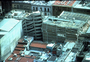
Downtown Mexico
City

Destruction of buildings in Mexico City (Photo: G. Pararas-Carayannis)

Downtown Mexico
City (Photo
by G. Pararas-Carayannis)
EARTHQUAKE
SOURCE PARAMETERS
 Date and Time of Occurrence - The great earthquake occurred
on 19 September 1985 at 13:17:47 UTC Date and Time of Occurrence - The great earthquake occurred
on 19 September 1985 at 13:17:47 UTC
Epicenter Location - Distances -The
epicenter of the great earthquake of 19 September 1985 was at
18.2 N, 102.5 W., about 50 km (appr. 31 miles) off the coast
of Mexico
Magnitude - The great earthquake 19 September
1985 earthquake had a magnitude of 8.1 (Ms). It was the largest
event that had occurred in Mexico since the Great Jalisco earthquake
of 1932. The magnitude was later revised by the USGS to 8.0
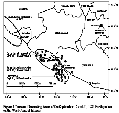
Epicenters and Aftershock
Distribution of the 19 and 21 September 1985 Earthquakes - Tsunami
Generation Area
Earthquake of 21 September
1985 - The major
earthquake which occurred 36 hours later on 21 September 1985
(the evening of Friday, September 20 local time), had a Richter
magnitude of 7.5. Its epicenter was at sea, approximately 100
Km SE of the epicenter of the 19 September great event, also
along the Michoacan gap. It is believed that this was a separate
earthquake rather than an aftershock.
Focal Depth - Both earthquakes had very shallow
focal depths.
 Aftershocks - There were many aftershocks after the main quake. Aftershocks - There were many aftershocks after the main quake.
Extensive
damage of the twelve-story high ,reinforced concrete building
of the Ministry of Communications and Transport resulted in the
near total collapse of long-distance communications between Mexico
City and the rest of the world - thus complicating coordination
of international rescue efforts.
Earthquake Death Toll,
Injuries and Damage - There
was severe damage in several states of Central Mexico and in
parts of Mexico City. According to official estimates, 10,000
people were killed, 50,000 were injured, and 250,000 people were
left homeless. It is believed that the death toll was underestimated
and that as many as 40,000 to 50,000 people may have lost their
lives.
In Mexico City alone
412 buildings collapsed and 3,124 others were heavily damaged.
There was extensive destruction at Ciudad Guzman in the State
of Jalsico, where approximaely 60% of all the buildings were
either destroyed or heavily damaged. Extensive damage was also
reported from other parts of the State of Jalisco as well as
in the States of Michoacan, Vercruz and Morelos. A total of about
6,000 buildings were either destroyed or so heavily damaged that
needed to be demolished.
There were also reports
of damage from landslides at Atenquique, in Jalisco, at Jala
in Colima, as wells as along the coastal roads near Ixtapa. Total
damage by the earthquake (and tsunami ) was estimated to be between
3- 4 billion U.S (1985) dollars. Most of the damage was caused
by the earthquake.
Ground
Movements - Intensities and Accelerations - Liquefaction Effects
The Great Earthquake
of 19 September 1985 caused strong ground motions which lasted
for about three to four minutes - a rather unusual duration even
for a great earthquake . Strong shaking was felt over an area
of about 825,000 square kilometers. Seismic intensities and accelerations
differed from point to point depending on geologic conditions.
The quake was felt by about 20 million people in Mazatlan, in
the State of Sinaloa to Tuxtla Gutierrez in the State of Chiapas,
and as far away as Corpus Christi, Brownsville, McAllen, Ingram
and El Paso and Houston, in Texas and even in Guatemala City.
 Mexico City - Although the epicenter was more than 300 Km
away, the valley of Mexico experienced surface seismic waves
with ccelerations up to 17% g. with peaks concentrated at 2 sec.
period (Quaas, et al, 1985). The maximum estimate of the Modified
Mercalli intensity was IX. Mexico City - Although the epicenter was more than 300 Km
away, the valley of Mexico experienced surface seismic waves
with ccelerations up to 17% g. with peaks concentrated at 2 sec.
period (Quaas, et al, 1985). The maximum estimate of the Modified
Mercalli intensity was IX.
Considerable liquefaction
and damage to new buildings occurred in Mexico City. The extreme
damage was attributed to the monochromatic type of seismic wave
with this predominant period causing 11 harmonic resonant oscillations
of buildings in downtown Mexico City which caused many buildings
to collapse. These ground accelerations were enhanced within
a layer of 30 ft. of unconsolidated sediments (of silt and volcanic
clay) underneath downtown Mexico City, which had been the site
of the historic Lake Texcocoa in the 15th Century. It is interesting
to note that most of the buildings that were destroyed - or heavily
damaged - were those that ranged between 8 and 18 stories in
height - which perhaps suggests a resonance effect of the horizontal
ground accelerations due to the short period ( 2-second ) seismic,
surface wave.
Playa Azul-Lazaro
Cardenas - Ixtapa - La Union - Maximum
registered intensity was IX in the region of Playa Azul-Lazaro
Cardenas (Ortega, et al, 1985) and at Ixtapa and La Union. Ground
fissures had predominant orientation in NW-SE direction. Liquefaction
effects and sand craters were observed in the coastal region.
Extensive ground fissures and sand craters were also observed
in the coastal area of Ixtapa.
Crustal Displacements
and Rupture Lengths - The Great Earthquake of 19 September 1985 had two major ruptures.
The horizontal displacements were estimated to be approximately
2.5 meters. A vertical displacement of 80 cm was measured in
hard rock north of the city of Lazaro Cardenas. Measurements
of crustal displacements were not available for the major earthquake
of 21 September 1985.
Earthquake
Source Area - The 19 September 1985 earthquake
affected an area of 185 x 75 Km2 or approximately 13, 875 Km2.
The 21 September 1985 earthquake affected an area having approximate
dimensions of 75 x 70 Km2 or roughly 5,250 Km2. A total of 63
aftershocks were roughly recorded ranging in magnitude from less
than 3 to more than 5. All of them had depths of 60 Km or less.
Earthquake Focal Mechanism
- The focal mechanism
of this earthquake corresponded to reverse faulting and was poorly
controlled. The seismic history and seismic potential of this
Michoacan gap have been uncertain and controversial in the past,
until this event. Data from first motion instruments indicated
that the main event was on a very shallow plane, which is typical
with the direction of subduction of the North American plate.
According to Cal Tech, long period, P-wave data, the depth was
17 Km for the hypocenter of the main event, while the depth of
the major aftershock was 22 Km. Also, long period seismometers
indicated that the main event resulted from two separate sub-events
separated by a time lapse of 27 seconds. The overall duration
was much longer than that of past events.
Earthquake
Energy - Energy flux calculations (Anderson, et al, 1985),
based on strong motion records of the main earthquake, indicated
a low dynamic stress drop, and when observed heat flow is taken
into consideration, a low absolute interplate stress.
An approximation of the energy of an earthquake can be obtained
from empirically derived relationships. Earthquake energy is
related to earthquake magnitude (M) by:
(1) Log10 E = 1.5 M + 11.8 (Gutenberg and Richter, 1954),
and earthquake magnitude is related to rupture length (l) by:
(2) M = 6.27 + 0.63 log10 l (Iida, 1958)
where l is measured in Kms, and M in Richter magnitude, for rupture
velocities of 3-3.5 Km/sec. If we combine (1) and (2) we get
(3) Log10 E = log10 l + 22.53 , or E = 3.3 x 10²² l in ergs.
Based on these empirically derived relationships, and using the
estimated earthquake source areas of both events, estimates of
the earthquake energy were obtained. For the main earthquake
of 19 September 1985 (M = 8.1 and l approximately 170 Km), the
energy of the earthquake (E1) can be approximated to be E1 =
5.61 x 1024 ergs. For the second earthquake (M = 7.5 and l =
30 Km), the approximate energy was estimated to be: E2 = 9.9
x 1023 ergs

Tectonic Setting
The Middle America
Trench defines the boundary between the Pacific, Cocos, and Nazca
plates as they subduct beneath the North American and Caribbean
plates. The Trench has been formed by an active subduction process
and stretches from central Mexico to Costa Rica for about 1700
miles (2,750 km). The segment of the trench (fronting the city
of Acapulco) is known as the Guerrero seismic gap. The last earthquake
along this particular gap was in 1911, so this area had and continues
to have, a high probability of recurring large earthquakes (Anderson
et al., 1985). The 19 September 1985 and the 21 September, 1985
earthquakes occurred along a segment that is characterized by
a low angle of subduction.
Recent Earthquakes - In the 20th century,
Mexico had about 42 earthquakes with magnitudes greater than
7.
THE
TSUNAMIS OF 19 AND 21 SEPTEMBER 1985 IN MEXICO - SOURCE MECHANISMS
Both earthquakes had their epicenters at sea. The first earthquake
of 19 September, in spite of its large magnitude, produced a
rather small tsunami. Movement in the vertical plane (0.8m) was
relatively small, the angle of subduction was shallow , and volumetric
displacement of the crustal block underneath the ocean was relatively
small.
The major aftershock (or separate earthquake) of 21 September
1985 had its rupture and its crustal displacements further out
to sea. Its subduction angle may have been somewhat steeper underneath
the North American plate, thus having a larger vertical component.
Although it affected a smaller area and had displacements for
only 50 Km, in terms of tsunami generation, it may have been
more efficient. This is illustrated by the Acapulco tide gauge
record in which both tsunamis of 19 and 21 September registered
almost equally, in spite of the large difference in earthquake
magnitudes. However, the source area for this second event was
closer to Acapulco.
Survey of
Tsunami Runup
The survey of the
coastal area affected by the tsunamis of the 19 and 21 September
1985 earthquakes covered the west coast of Mexico from Manzanillo
to Zihuatanejo. Runup measurements were made and interviews with
local residents in the coastal areas were conducted. The tsunami
measured from 1 meter to approximately 3.0 meters from Manzanillo
to Acapulco. The tsunami caused some damage at Lazaro Cardenas,
at Zihuatenejo and at Manzanillo. Tide stations recorded maximum
wave heights (peak-to-trough) of 1.4 meters at Acapulco, Mexico.
There were some reports that some ships off the Pacific coast
of Mexico observed unusually heavy seas near the time of the
earthquake. However these waves may have been caused by local
storms.
Manzanillo - A tsunami height in the order
of 1 meter was reported.
Zihuatanejo - Maximum wave heights of approximately
3.0 m were measured .
Lazaro Cardenas - This was the town
closest to the epicenter where the maximum tsunami height was
estimated at approximately 2.8 meters, with inland inundation
of up to 180 feet. Tsunami damage to coastal structures, due
to the effects of flooding and erosion, was relatively minor.
Tsunami
Tide Recordings at Distant Locations
La Libertad, Ecuador
- 60 cm
Acajutla, El Salvador
- 58 cm 24 cm
Kahului, Hawaii and
at Pago Pago, American Samoa; 22 cm Hilo, Hawaii
Baltra Island, Galapagos
- 21cm
Apia, Western Samoa
- 14 cm
Rikitea, Gambier Islands
- 7 cm
Papeete, Tahiti -
5 cm
Tsunami Generating Area
As indicated previously
(see diagram of estimated tsunami generating areas), the total
area affected by the 19 September earthquake had approximate
dimensions of 185 x 75 Km2, or 14,000 Km2. Approximately one
half of this area was in the ocean, so effectively the tsunami
generating area was only 7,500 Km2, which is only a small fraction
of the ocean floor area usually affected by large earthquakes.
For example, the Great Alaskan earthquake (M=8.5) affected a
total area of approximately 215,000 Km2 and the tsunami generating
area was in the order of 175,000 Km2 (Pararas-Carayannis, 1972),
or approximately more than twenty times greater than the area
affected by the 19 September Mexican earthquake. This partly
explains the relatively small tsunami generated by this large
Mexican earthquake.
The 21 September earthquake, although much smaller in magnitude
(M=7.5), affected a smaller area estimated at 75 x 70 Km2 or
approximately 5,000 Km2. However, all of the affected area was
in the ocean, so the tsunami generating area was also approximately
5,000 Km2. The records of the tsunamis from the two events as
recorded in Acapulco, show that the second event produced a tsunami
which was very similar in size to the one generated by the larger
event. This indicates that the efficiency of tsunami generation
of the smaller event may have been greater than that of the larger
event.
Tsunami
Energy
The energy transfer
of the earthquake to tsunami energy cannot be calculated directly
because there were not extensive measurements of the crustal
displacements associated with either the 19 September, or the
21 September earthquakes. The crustal measurements given have
been inferred from first motion instruments. For the major quake,
it is assumed that horizontal movement was 2.5 m, and vertical
displacement was 0.8 meters. Based on these quantities and on
the geometry of faulting, an estimate of the tsunami energy was
obtained as follows.
Assuming that the total tsunami energy (Et) was equal to the
potential energy (Ep), of the uplifted volume of water in the
tsunami generating area, then this total tsunami energy can be
estimated to be:
Et = 1/6 rgh2 ·A = 1/6 (1.03) (.980) (103) (104) (0.82)
(1.85 x 10⁷) (7.5 x 10⁶) =
0.74 x 10²⁰ ergs
where:
Et = Ep = Total Energy in the submerged portion of the earthquake
area
r = 1.03 gm/cm3 = density
g = 980 cm/sec3
h = Height of vertical displacement = 0.8 m
A = Tsunami Generating Area, 7,500 Km2
1 erg = gr cm3 sec3
For the 21 September tsunami, the energy is roughly estimated
to be:
Et = 5.6 x 10¹⁹ ergs or 0.56 x 10 raised to 20 power - ergs
This is based on the assumption that the vertical displacement
for the second earthquake was also 0.8 m. However, inspection
of the Acapulco record shows that both tsunamis were of the same
approximate height. Therefore, the second earthquake must have
been more efficient or had an angle of subduction that was greater,
so the vertical component of the crustal movement could have
been more than 0.8 m, and the tsunami energy proportionately
greater.
Can earthquakes
along the Western coast of Mexico generate destructive tsunamis?
The perception that
tsunamis do not pose a threat in Western Mexico is erroneous.
The historic record shows that about 15 destructive local tsunamis
were generated in the last three centuries, (SoLoviev and Go,
1975) from earthquakes along the Middie America Trench. The wave
heights of these tsunamis has ranged from 2 meters to a maximum
of 9 meters.
REFERENCES
AND ADDITIONAL BIBLIOGRAPHY
Singh, K.S., Ponce, L. and Nishenko, P.S. "The Great Jalisco, Mexico,
Earthquake of 1932: Subduction of the Rivera Plate.", "Bulletin of Seism. Soc.
Amer., Vol. 75, No. 5, pp. 1301-1313, October 1985."
Anderson, J., Bodin P., Brune, J., Masters, G., Vernon, F., Almora,
D., Mena, E., Onate, M., Prince, J., Quaas, R., and Singh, K. "Strong Ground
Motion and Source Mechanism of the Mexico Earthquake of September
19, 1985," Proceedings
"Simposio El Temblor De Michoacan 1985 y Sus Efectos"
Oaxaca, Un. Geof. Mexicana - Instituto Technologico De Oaxaca,
10-16 November 1985.
Astiz, L., Eissler, M. and Kanamori, H. "Source Parameters of the September 1985,
Mexico Earthquakes" Seismological
Laboratory, Cal Tech, Pasadena, Proceedings "Simposia El
Temblor De Michoacan 1985 y Sus Efectos" Oaxaca, Un. Geof.
Mexicana - Instituto Technologico De Oaxaca, 10-16 Nov 1985.
Bodin, P. and T. Klinger. Observations of coasta
I uplift associated with the 1985 Mexican subduction earthquakes (abstract), American Geophysical
Union, Fall Meeting, San Francisco, California, 1985.
Iida, Kumizi "Magnitude
and Energy of Earthquakes Accompanied by Tsunami and Tsunami
Energy." Journal
of Earth Sciences, Nagoya Univ., Vol. 6, No. 2, pp 101-112, Dec.
1958.
Farreras F. Salvador and Antonio J. Sanchez, 1985, GENERATION,
WAVE FORM, AND LOCAL THE SEPTEMBER 19, 1985 MEXICAN IMPACT OF
TSUNAMI
Gonzalez-Ruiz, J.,
C. Rebeltar, and K. McNally. Preliminary
source characteristics of the September 19/20, 1985 MEXiC0 earthquake
from body wave observations,
Additional Abstracts to E.0.S., Transactions American Geophysical
Union, PP. 98, 1985.
Gutenberg, B. and Richter, F.C. "Seismicity of the Earth and Associated
Phenomena," 2nd
Edition, Princeton Univ. Press, Princeton, New Jersey, 310 pp,
1954.
Pararas-Carayannis, G. "Source
Mechanism of the Water Waves Produced." Reprinted from Pacific Science, Vol. 21, No.
3, "A Study
of the Source Mechanism of the Alaska Earthquake and Tsunami
of March 27, 1964." Volume on Seismology and Geodesy on the Great Alaska Earthquake
of 1964, National Academy of Sciences, Washington D.C., pp 249-258,
1972.
Pararas-Carayann
Is, G. A summary
of findings of the ITIC mission in Mexico sponsored by the Intergovernmental
Oceanographic Commission (UNESCO), 6 PP. manuscript, International Tsunami information
Center, December 1985.
Preuss, J., R. Preuss,
A.J. S&nchez, and S.F. Farreras. Update on tsunami effects of the September 1985
Mexico earthquake, Tsunami Newsletter, XiX, 2:7-9, Juiy 1986.
Singh, S.K., L. Astiz,
and J. Havskov. Seismic
gaps and recurrence periods of large earthquakes aiong the Mexican
subduction zone:
a re-examination, Bulietin of the Seismological Society of America,
71:827-843, 1981.
Singh, S.K., M. Rodriguez,
and J.M. Espindosa. A
catalog of shallow earthquakes of Mexico, 1900-1981, Bulletin of the Seismological Society
of America, 74:267-279, 1984.
Soioviev, S.L. and
Ch.N. Go. A catalogue
of tsunamis on the eastern shore of the Pacific Ocean (1513-1968), 204 pp., Moskow , USSR: Nauka
Pub. House, 1975.
UNAM Seismology Group. The great Michoacan,
Mexico earthquake of 19 September 1985: some seismological aspects (preliminary resuits)
, Abstracts of the American Geophysical Union Meeting, San Francisco,
California, 1985.
| |
|
©1982 - 2011 Dr. George Pararas-Carayannis - All rights reserved
Last update: June 22, 2011 |
|
|
| |
|
|
|
|
|
|