|
EARTHQUAKE
AND TSUNAMI OF FEBRUARY 21, 1996 IN NORTHERN PERU
George Pararas-Carayannis

 INTRODUCTION
A large earthquake
off the northern coastal region of Peru caused minor damage but
generated a local destructive tsunami in the Chimbote region
of Peru.
THE EARTHQUAKE
OF 21 FEBRUARY 1996
Epicenter - 9.6783
South Latitude, 79.798 West Longitude, near the Peru-Chile Trench,
off the coast of Northen Peru.
Time of Origin - 12:51:04.4 GMT, February 21,
1996 (7:51 a.m., February 21, 1996, local time and date)
Magnitude - Mw 7.5
Focal Depth - Shallow.
Fault Plane - According to the Harvard University
determination the earthquake source had the following parameters.
PRINCIPAL AXES: AZM
PLG1. (P) 245 30,2. (T) 61 60 3. (N) 154 2
STRIKE DIP - NP1:340
15 , NP2:153 75
Aftershocks - Numerous aftershocks occurred
from 120 to 180 Km off the coast of Peru near the Peru-Chile
trench and appreared to be parallel to the Peruvian coastline.
Rupture Speed - The rupture velocity was classified
as moderately slow (Newman and Okal, 1996).
 Felt Reports - Most of the local residents reported that they
did not feel the ground motions of the earthquake. Some reported
only moderate shaking. Felt Reports - Most of the local residents reported that they
did not feel the ground motions of the earthquake. Some reported
only moderate shaking.
Death Toll and Damages
- The earthquake
caused very little damage.
Most of the deaths
and damages were caused by the tsunami. The
tsunami killed 12, injured 54 (one gravely), damaged 37 homes
(15 completely destroyed) and 25 boats (2 destroyed). Some of
the fatalities were to line fishermen who were caught on the
rocks by the waves. Additional fatalities occurred in the area
of Santa, north of Coishco and at the beach of Campo Santa. More
details below.

Tectonic
Setting and Seismicity of the Central and Northern Peru Region
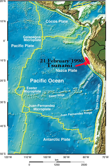
The Peru-Chile Trench
- also known as the Atacama Trench - is the active boundary of
collision of the Nazca Plate with the South American Plate. Subduction
of the Nazca plate beneath the South America continent is not
homogeneous. As a resut , asperities and structural complications
have caused segmentation along the entire margin, resulting in
zones with different rates of slip, seismic activity, volcanism,
uplift, terracing and orogenic processess. Different sections
of the margin along the Great Peru-Chile Trench, are segmented
by great fractures. Each segment has its own characteristic parameters
of collision and structural geometry and, thus, different potential
for large earthquakes and destructive tsunamis.
The February 21, 1996
earthquake occurred along an area of high seismicity off the
west coast of Northern/Central Peru, near the latitude of Chimbote.
It was caused by reverse thrust faulting and uplift on the landward
side of the Peru-Chile Trench on the over-riding tectonic plate
- along the boundary where the Nazca plate subducts beneath the
South American plate under extreme compressive force. However,
the structure of the subducting oceanic Nazca plate is complex
(Pedoja et al. 2003). According to Le Pichon et al. (1973), the
velocity of subduction of the Nazca plate near the south Chile
and north Peru region is about 8.7 - 8.8 cm/y.
Seismicity of the
Central and Northern Peru Region - The historical record supports that the rate
of subduction is not uniform and there is significant fragmentation
along the entire length of the margin as well as differential
uplift of the continental block. Certain tectonic block segments
along the Peru-Chile tectonic boundary have the capability to
generate very large earthquakes. In recent times, large earthquakes
in regions of high rate of subduction have resulted in uplifting
and terracing sections of the South American coast by as much
as a few meters. Marine terraces and evidence of tectonic segmentation
is also evident along the entire North Peruvian and Ecuadorian
active margin. The ongoing process is responsible for the active
orogenesis that is taking place and has created the young Andean
mountain range.
Strong, destructive
earthquakes and active orogenesis are evident off Northern/Central
Peru between the Mendana Fracture Zone (MFZ) and the Nazca Ridge.
Even though the Nazca Plate appears to be subducting smoothly
and continuously at about 7-9 cm/yr into the Peru-Chile trench
in this region of Northern/Central Peru, the deeper parts of
the subducting plate appear to break into smaller pieces that
become locked in place for long periods of time before generating
large earthquakes.
 The February 21, 1996 earthquake
occurred along one of three distinct seismic zones in the Peruvian
upper mantle (Ocola, 1966, Pararas-Carayannis, 1974). The seismic
activity of this zone is most pronounced between the Andean Mountain
block and the Peru-Chile trench. This narrow seismic band (100
to 150 km wide) is under Peru's Continental Shelf and is characterized
by shallow earthquake activity and has great tsunamigenic potential
(Pararas-Carayannis, 1968, 1974). The February 21, 1996 earthquake
occurred along one of three distinct seismic zones in the Peruvian
upper mantle (Ocola, 1966, Pararas-Carayannis, 1974). The seismic
activity of this zone is most pronounced between the Andean Mountain
block and the Peru-Chile trench. This narrow seismic band (100
to 150 km wide) is under Peru's Continental Shelf and is characterized
by shallow earthquake activity and has great tsunamigenic potential
(Pararas-Carayannis, 1968, 1974).
The region (from 7.5
to 12.5 degrees South latitude) has produced at least seven destructive
earthquakes in the vicinity of Chimbote and Lima-Callao. These
occurred on: 9 July 1586; 13 November 1655; 20 October 1687;
28 October 1746; 30 March 1828; 24 May 1940 (M = 8.4); and 17
October 1966 (M = 7.5) (Pararas-Carayannis, 1974). Of these,
the earthquakes of 1586, 1687, 1746, 1828 and 1966 are documented
to have produced destructive tsunamis (lida el al., 1968, Pararas-Carayannis,
1974).
The seismicity of
this particular region can be expressed taking into account ,
not only the number of recorded past events but also their size,
frequency, and spatial distribution (Pararas-Carayannis, 1974).
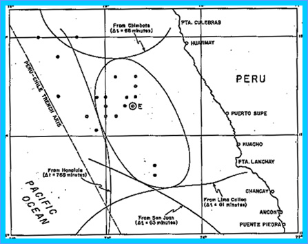
For example, Ocola (1966) processed all earthquakes which occurred
in the area during a 14 1/2-year period and prepared an earthquake
energy release map which illustrates quite well the seismicity
of this particular region. This map was prepared using the empirical
relationships of earthquake energy, magnitude, and frequency,
derived by Gutenberg and Richter (1956), by plotting the energy
release of equivalent earthquakes of magnitude 4 (Richter scale).
The figure provided here is a section from Ocola's map showing
the earthquake energy release off the coast of central Peru from
January 1949 to July 1963. The energy density contours are in
units of 10 raised to the 19th power of ergs per 1 degree of
latitude by 1 degree of longitude, for the 14 1/2-year period.
The 1966 earthquake occurred within the band of highest activity
shown in this figure. The February 21, 1996 earthquake also occurred
within this band.
Although this map
was prepared more than 40 years ago, and for a relatively short
time interval, earthquake events which have occurred since -
including the February 21, 1996 event - do not show significant
change in the seismicity pattern in this region of Central and
Northern Peru.
The orientation of
the contours of energy release indicate general trends striking
N30W, and are in agreement with the general trend of the fault
systems, the Andean Mountains, and the alignment of the Peru-Chile
trench in this Central and Northern region of Peru. Specifically,
the Peru-Chile trench in this region is oriented at about N30W
and the northern part of the Andean Mountains are oriented at
about N32W. Similarly, major outcrops of intrusive rocks along
the coast have general orientations at N20W and N55W. The fault
plane parameters calculated by Harvard University for the February
21, 1996 earthquake have similar azimuthal orientation. The distribution
of earthquake aftershocks for this event appear to parallel the
Peruvian coastline, also with similar orientation.
THE
TSUNAMI OF 21 FEBRUARY 1996 IN NORTHERN PERU
 Earthquakes with slow rupture
rates, also known as "tsunami earthquakes" - or often
as "silent earthquakes" - appear to be efficient tsunami
generators. Such earthquakes do not produce intense ground motions
and often are not strongly felt. Such a silent earthquake struck
Central America in 1992 and generated a destructive tsunami in
Nicaragua, Costa Rica and elsewhere in Central America. It cought
people by surprise because its ground motions were not significant. Earthquakes with slow rupture
rates, also known as "tsunami earthquakes" - or often
as "silent earthquakes" - appear to be efficient tsunami
generators. Such earthquakes do not produce intense ground motions
and often are not strongly felt. Such a silent earthquake struck
Central America in 1992 and generated a destructive tsunami in
Nicaragua, Costa Rica and elsewhere in Central America. It cought
people by surprise because its ground motions were not significant.
The earthquake of
21 February 1996 had a rupture of moderate speed which suggests
that it occurred within compacted sediments along the tectonic
margin region. Perhaps it was this reason that its ground motions
were not strongly felt. The earthquake, although of moderate
magnitude, generated a disproportionally large tsunami which
had a maximum runup in excess of 5 meters.
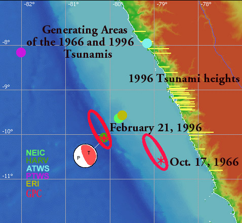
Source area and observed
coastal wave height distribution of the February 21, 1996 Peru
Tsunami. Epicenters of the main shock are shown as reported by
different agencies. {Modified Graphic of Tsunami Laboratory (Institute
of Computational Mathematics and Mathematical Geophysics, Novosibirsk,
RUSSIA)}. Superimposed are the Source mechanism as determined
by Harvard University and the Estimated
Generating Areas of the 1996 and 1966 tsunamis and length of
earthquake ruptures (about 120 Km) (Pararas-Carayannis, 1974,
1996).
The tsunami of 21
February 1996 did not generate a Pacific-wide tsunami but it
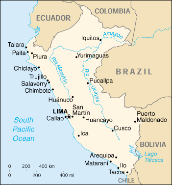
affected 590 km of coastal area extending from Pascasmayo, in
the department of La Libertad, to the Port of Callao, near the
capital, Lima. As previously reported most of the deaths and
damage were caused by the tsunami. Fortunately the waves struck
in the early morning hours when there were not too many people
along the waterfront. Also, the tsunami death toll and damage
were mitigated by the mere coicidence that most regional ports
in the region had been closed for five days prior to the tsunami
because of a heavy storm and dangerous waves. For the same reason,
several of the larger ships had seeked refuge to deeper waters
offshore - thus minimizing potential losses.
The tsunami killed
12, injured 57 (one gravely), damaged 37 homes (15 completely
destroyed) and 25 boats (2 destroyed). Some of the fatalities
were to line fishermen who were caught on the rocks by the tsunamis.
In all, the tsunami destroyed or damaged several houses and boats,
caused some damaged to port and harbor facilities, ruined crops,
and damaged the beachfront property of several resorts in the
area.
Tsunami Travel Time
- The tide gauge
at Port of Chimbote showed that the first wave arrived shortly
after 9:00 a.m. (local time) - which indicates a tsunami travel
time of about 70 minutes from the source region.
Eyewitness Reports
- According to coastal
residents the tsunami's arrival was preceeded by a marked withdrawal
of the sea. The tsunami was described as progressive flooding
of the coast by three waves in rapid succession. There was no
breaking of the waves. The second of the waves was reported as
being the highest. According
to Peruvian Civil Defense, the citizens of Chimbote (located
closest to the epicenter) evacuated the waterfront area when
they noticed the withdrawal of the water from the shore. However,
it is unclear whether people in other smaller coastal communities
recognized or knew of the impending tsunami natural warning signs.
 Near Field Tsunami Effects and Runup Near Field Tsunami Effects and Runup
The tsunami was destructive
locally. The near field effects and the runup of the tsunami
were extensively surveyed in March of 1996 by an International
Team of scientists from Peru, Canada, and USA. Their findings
were subsequently reported in the literature (Bourgeois et al.
1999). The team conducted interviews with local residents and
reported the following tsunami runup values for the Chimbote
region. For more details regarding this field survey, please
refer to the reference for Bourgeois et al, 1996 or visit the
University of Southern California Research Group Website at http://www.usc.edu/dept/tsunamis/peru/ptsu_1996.html
Chimbote - At
the Port of Chimbote, on the north side of Chimbote Bay, tsunami
waves inundated 800 m landward of the main dock, overturned a
truck, beached small boats, and transported a steel guard shack
for a distance of about 20 m. However, no major damage to other
structures occurred in the Bay. The University of California
team which surveyed the area subsequently reported that the highest
runup of 5.14 meters was measured there. As mentioned, the port
had been closed for five days prior to the tsunami due to high
storm wave conditions and that prevented losses of life in Chimbote
Bay.
The normal tide variation
for Chimbote is approximately 1m. The corrected maximum runup
that was recorded was 2.8 m. Altough the tsunami innundated the
beach in the bay, it did not damage structures.
Samanco Bay - At Samanco Bay, immediately
south of Chimbote, the tsunami transported boats as far as 300
meters inland. The most dramatic runup effect occurred at a tomblo
(low strip of land connecting a headland to the mainland) separating
Chimbote and Samanco Bays, where the tsunami inundated the entire
1.5-kilometer wide by 4.5-kilometer long tombolo.
Coishco - According
to the survey, the
tsunami runup exceeded 5 meters at the town of Coishco, to the
north of Chimbote. According to reports, a 30 meter long brick
wall was destroyed and several houses along the waterfront were
damaged by the waves. Additional fatalities occurred in the area
of Puerto Santa, just north of Coishco and at the beach of Campo
Santa. The dead included 6 fishermen near Coishco , four people
who were gathering firewood near the mouth of the Santa River,
and two children looking for gold on the beach at Cameo Santa.
Bahia Los Chimus - There was flooding at Bahia
Los Chimus, about 30 Km south of Chimbote all the way to the
town's plaza.
Casma - Further south of Chimbote, according
to the survey, the tsunami runup at Casma and the vicinity ranged
from 1.8 m to as much as 3.48, just north of the town.
Casma to Puerto Supe
- The tsunami runup
ranged from .85 meters to a maximum of 4.59 m. At Puerto Supe
the tsunami runup was determined by the survey team to be 1.89
meters.
Pacasmayo to Chimbote
- Further North of Chimbote and over a total distance of about
300 km. the tsunami runup ranged from 0.86 to a maximum at 3,46
meters between Trujillo and Salaverry.
Small tsunami Recorded
by Distant Tide Gauge Stations - The tsunami was recorded by mid-Pacific tide
gauges. It was 60 cm at Easter Island, and 25 cm at Hilo, Hawaii.
Tsunami Energy - Given the similarities of the
source dimensions and magnitude of the 21 February 1996 earthquake
with that of the 17 October 1966 earthquake in the same general
area, the energy of the earthquake is estimated to be 1.12X 10
(raised to the 23 power) ergs. Similarly the combined energy
release of the aftershocks is estimated to be 2.357 X 10 (raised
to the 20th power) ergs. It is estimated that the 21 February
1996 tsunami was generated by ocean floor displacements which
affected close to 13,000 sq. Km. Thus the energy that went into
tsunami generation is estimated to be 6.8X10 (raised to the 19th
power ergs) or approximately 1/1,650 of the total energy of the
earthquake.
 Past Earthquakes and
Tsunamis in the Northern Peru Region Past Earthquakes and
Tsunamis in the Northern Peru Region
The Earthquake and
Tsunami of 17 October 1966 -
A similar earthquake to the 21 February 1996 occurred on 17 October
1966, The 1966 earthquake had a similar magnitude of 7.5 but
sightly south and closer to the Peru's coastline. The epicenter
of the 1966 earthquake quake was at 10.7 S Latitude and 78.7°W
Longitude off the coast of Pativilca of Central Peru, 190 Km
northwest of Lima (U. S. C & GS, 1966). Its focal depth was
60 Km deep. The earthquake affected a coastal belt 400 Km long
and less than 50 Km wide, and severely damaged the towns of Huacho,
Huaura, Puente Piedra and sectors of Lima-Callao. The highest
intensity was observed in the vicinity of Huaura and may be related
to a fault between Upper Jurassic and Lower Cretaceous sediments
(Lommitz and Cabre', 1968). Effects of high intensity were also
observed near the outlets of rivers and other areas of recent
alluvium deposits.
The quake generated
a large tsunami which caused destruction along the Peruvian coast
from Chimbote in the North to San Juan in the South. (Pararas-Carayannis,
1968.) The greatest wave at Callao had a range of 3.40 m height
(range between maximum crest and trough) and tsunami waves exceeding
3 meters in amplitude (height above undisturbed water level)
inundated La Punta, Chuito, Ancon, Huaura, Huacho, and the resort
of Buenos Aires in the City of Trujillo. Within 60-70 minutes
after the quake, tsunami waves arrived at the cities of Chimbote
and San Juan, which are about 800 Km apart. Devastating effects
were experienced at Casma and Calota Tortuga where waves exceeding
6 meters in range destroyed many structures. (Pararas-Carayannis,
1968.) The port of Casma, about 360 Km north of Lima, suffered
the greatest damage. Losses from this tsunami were estimated
at about $4 million (1966 dollars) (40 million Peruvian Soles.
Many fish-flour factories and the harbor wharf were severely
damaged. Tsunami destruction also occurred at Puerto Chimu and
Culebras (El Commercio de Lima, Peru, 18, 19 October 1966). The
tsunami caused no damage outside Peru, but was recorded by tide
gauges throughout the Pacific Ocean. (Beckman and Carrier, 1967).
Historical
Tsunamis in the Central/Northern Peru Region
(Source: Iida,
Cox, Pararas-Carayannis, 1967)
1586, 9 July - 0 30 Reconstructed Epicenter
- 12.20 South 77.70 West, Off Lima/Callao, Peru. Reconstructed
Magnitude 8.5 3.5 4.0 26.00 5 L 20 T 4 Destructive Tsunami. The
shore inundated for 10 km inland. Tsunami Height at Trujillo
26 meters.
1655, 13 November
- 19 38 Reconstructed
Epicenter 12.00 South, 77.00 West, Off Lima/Callao. No details.
1678, 17 June - No details. At Santa sea receded
and later returned with destructive violence. Ship carried far
inland (alternate date given January 18)
1687, 10 20 - 9 30 Reconstructed Epicenter
13.50 South, 76.50 West Magnitude 8.5 3.5 1.0 8.00 14 M 5000
T 4 SAM LOC Off Callao. At Callao and Chancai Pisco, the sea
retreated then returned with great violonce. Town and market
were destroyed. No other details.
1746, 10 29 - 3 30 Reconstructed Epicenter
12.50 South, 77.00 West, Magnitude 8.0 3.5 4.6 24.00 7 L 18000
T 4
Near Callao the tsunami
height was 24 meters. Portion of the coast sank producing a bay.
All ships in the harbor were destroyed or beached. One ship stranded
about 1.5 km inland. Of 5,000 inhabitants only 200 survived.
At Cavallos, Chancay and Gaura the effects of the tsunami were
similar.
1828 3 30 - 12 35 Reconstructed Epicenter
12.10 South, 77.80 West 50 8.2 No details available. Only that
the tsunami was destructive to cities north of Lima (Callao).
1940 5 24 - 16 33 Epicenter 10.50 South,
77.00 West 60 8.4 7.8 1.5 1.0 2.00 1 S 250 T 3 No details available
1942 August 24 - Epicenter 15 South 76 West,
Magnitude 8.1 Shallow. Tsunami at Callao - 1.6meter wave with
period of 30 min. Travel time to Callao 0.7 hour; At Matarani
0.5 meters, Travel Time 1.7 hour. Tsunami wave period 21 min.
1966 10 17 - 21 42 Epicenter 10.70 South,
78.80 West 38 7.8 8.1 8.2 1.5 1.6 3.00 67 M 125 T 4
Tsunamigenic
Potential of Central/Northern Peru - Future Impact
Tsunamigenic earthquakes
with magnitudes up to 7.8 - similar to that of February 21, 1996
and of October 17, 1966 - are possible for the region of Central/Northern
Peru and will occur again in the future. Based on stresses generated
by the present rates of subduction of the Nazca plate below the
South American plate, such large tsunamigenic earthquakes could
occur on the average of every 30-40 years.
Also, since subduction
in this northen region off Peru is not homogeneous - and there
is apparent locking of tectonic blocks - a large earthquake can
be expected in the future further north from the region affected
by the 1966 and the 1996 tsunamigenic earthquakes. According
to Erik Flesch (Department of Geosciences, University of Arizona)
further north - between the Carnegie Ridge off Ecuador and the
Mendana Fracture Zone (MFZ) off northern Peru - there has been
a seismic gap of at least two hundred years. This seismic gap
could be the source region for future large earthquakes (perhaps
with magnitudes up to 7.8) that could generate destructive tsunamis
that could affect the coastlines of northern Peru and southern
Ecuador. However, the geometry of subduction and the segmentation
of the tectonic blocks in this gap region is such that would
most likely limit the lengths of ruptures of such earthquakes
to perhaps no more than 150 km - which would also limit the far
field effects of potential tsunamis from this particular gap
region of the Peru-Chile Trench.
The Central/Northern
Peru Region along the Peru-Chile Trench - bounded by the Mendana
Fracture Zone (MFZ) to the North and the Nazca Ridge to the South
- has unique mechanisms of generating destructive local tsunamis
but historically has not generated tsunamis with far reaching
Pacific-wide effects. However, segments further south of the
Nazca Ridge (closer to Arica, Latitude 18-20 South), the region
off Central Chile and and even further south than the Juan Fernandez
Ridge, have different structural geometries and can generate
great earthquakes with greater ruptures and tsunamis with far
reaching, Pacific-wide impact. One example would be the segment
between 15 and 18 degrees South latitude which generated the
1868 Pacific-wide tsunami. Another segment would be from the
Chiloe Fracture Zone to the Taitao Fracture Zone, where the great
Chilean earthquake of May 22, 1960 occurred (with epicenter at
39.50 South, 74.30 West). The rupture of this earthquake and
the tsunami generating area extended all the way past the Darwin
Fracture Zone (about 46 South latitude) to Chile's triple point
junction with the Antarctic plate near the Taitao Fracture Zone.
The potential for large or great earthquakes that could generate
Pacific-wide tsunamis along South America will be further discussed
in a future analysis.

REFERENCES
AND ADDITIONAL BIBLIOGRAPHY
Berckman, C. S. and
Carrier, D. D., 1967; "The
Tsunami of October 17, 1966, as Recorded by Tide Gages". Tides Branch, U. S. Coast and
Geodetic Survey Informal Pamphlet, 8 March.
Beck, S., and G. Zandt
(2002). The nature of orogenic crust in the central Andes,
J. Geophys. Res. 107(B10), 2230.
Berninghausen W.H.,
Tsunamis Reported
from the West Coast of South America 1562-1960, Bull. of Seismol. Soc. Am. 52(4), pp. 915 -
921
J. Bourgeois, C. Petroff,
H. Yeh, V. Titov, §, C. E. Synolakis, B. Benson, J. Kuroiwa,
J. Lander, E. Norabuenam, 1999.
Geologic Setting,
Field Survey and Modeling of the Chimbote, Northern Peru, Tsunami
of 21 February 1996. Journal
of Pure and Applied Geophysics, Earth and Environmental Science
Issue, Volume 154, Numbers 3-4 / May, 1999, Pages 513-540
Fisher, R. L. and
Raitt, W. R. (1962); "Topography
and Structure of the Peru-Chile Trench", Deep Sea Res., 9, 423-443.
Dorbath, L., Cisternas,
A., and Dorbath, C. 1990, Assessment
of the Size of Large and Great Historical Earthquakes of Peru, Bull. Seismol. Soc. Am. 80(3),
pp. 551 - 576.
Giovanni, M., S. Beck,
and L. Wagner 2002). The
June 23, 2001 Peru Earthquake the southern Peru subduction zone, Geophys. Res. Lett. 29(21),
2018, doi:10.1029/2002
Gutenberg, B. and
Richter, C. F., 1956. Earthquake
magnitude, intensity, energy , acceleration, 2. Bull. Seismo!. Soc. Am., 46 (2):105-143.
Iida, K., D. Cox and
G. Pararas-Carayannis, 1968; "Prelim.
Catalogue of Tsunamis Occurring in the Pacific Ocean", Hawaii Institute of Geophysics,
Univ. of Hawaii, Data Rept. No. 5.
Lockridge, P.A., 1985
Tsunamis in Peru-Chile, World Data Center A for Solid Earth Geophysics
Report SE-39, 97 pp.
Lomnitz, C., and Cabre'
R. 1968, "The
Peru Earthquake of October 17, 1966", Bull. Seism. Soc. Am., Vol. 58, No. 2, pp.
645-661, April.
Newman A.V., and Okal,
E.A., 1996, Source
Slowness of the February 21, 1996 Chimbote Earthquake Studied
from Teleseismic Energy Estimates, EOS 77(17), S184.
Ocola, L., 1966. "Earthquake Activity of
Peru", Am. Geophys.
U., Geophys. Monograph 10, 509-528.
Pararas-Carayannis,
G. 1968, "The
Tsunami of October 17, 1966 in Peru", International Tsunami Information Center Newsletter,
Vol. 1, No. 1, March 5.
Pararas-Carayannis,
George. 1974, An
Investigation of Tsunami Source Mechanism off the Coast of Central
Peru. Marine Geology,
Vol. 17, pp. 235-247, Amsterdam: Elsevier Scientific Publishing
Company, 1974.
Pararas-Carayannis,
G. and Calebaugh P.J., 1977. Catalog
of Tsunamis in Hawaii,
Revised and Updated , World Data Center A for Solid Earth Geophysics,
NOAA, 78 p., March 1977.
K. Pedoja, J.-F. Dumont,
M. Lamothe and Auclair, M. 2003. MARINE TERRACES ON THE NORTH PERUVIAN AND ECUADORIAN
ACTIVE MARGIN: TECTONIC SEGMENTATION, Geophysical Research Abstracts, Vol. 5, 12200,
2003 European Geophysical Society
W. Spence, C. Mendoza,
E. R. Engdahl, G. L. Choy, E. Norabuena, 1999. Seismic Subduction of the Nazca Ridge as Shown
by the 199697 Peru Earthquakes. JournalPure and Applied Geophysics, Earth and
Environmental Science
Issue, Volume 154, Numbers 3-4 / May, 1999Pages, 753-776.
Swenson, J. L. and S. L. Beck 1999. Source characteristics of the 12 November 1996
MW 7.7 Peru subduction zone earthquake, PAGEOPH 154(3-4), 731-751.
SEE ALSO:
Pararas-Carayannis,
G. THE SOURCE MECHANISM
OF THE EARTHQUAKE AND TSUNAMI OF OCTOBER 17, 1966 IN PERU
http://drgeorgepc.com/Tsunami1966Peru.html
Pararas-Carayannis,
G. Earthquake and
Tsunami of 23 June 2001 in Southern Peru
http://drgeorgepc.com/Tsunami2001Peru.html
University of Southern
California Research Group Website, The 1996 Chimbote Tsunami http://www.usc.edu/dept/tsunamis/peru/ptsu_1996.html
Return to

  Links to other
Pages
Links to other
Pages

 Now available
from Amazon, Barnes and Noble and other major bookstores. A signed
by the author copy can be also ordered by contacting directly
by email Aston
Forbes Press.
Now available
from Amazon, Barnes and Noble and other major bookstores. A signed
by the author copy can be also ordered by contacting directly
by email Aston
Forbes Press.
 Other
Miscellaneous Non-technical Writings
Other
Miscellaneous Non-technical Writings
(©) Copyright
1963-2007 George Pararas-Carayannis / all rights reserved / Information
on this site is for viewing and personal information only - protected
by copyright. Any unauthorized use or reproduction of material
from this site without written permission is prohibited.
|