|
THE
EARTHQUAKE AND TSUNAMI OF 17 JULY 1998 IN PAPUA-NEW GUINEA (PNG)
George
Pararas-Carayannis
(Based
on data and illustrations gathered from various sources and from
previous studies of the tsunami hazard for PNG prepared by the
author for the United Nations Development Program (UNDP) as part
of a Five Year Plan for the Development of A Regional Tsunami
Warning System in the Southwest Pacific)

 INTRODUCTION INTRODUCTION
A major earthquake
off the northern coast of Papua - New Guinea (PNG) generated
one of the most destructive tsunamis to strike this country in
recent years. There was no warning. The tsunami killed thousands
of people and left more than 6,000 people homeless. Many more
were missing.
As of July 20, 1998,
almost 5,300 of more than 10,000 people who lived in the devastated
villages had been accounted for, with 3,370 survivors at three government
relief centres, 713 admitted to hospitals and 1,212 buried. As
of August 15, 1998, the death toll had risen to more than 3,000.
The final death toll may never be known with certainty.

 The Earthquake of 17
July 1998, in Papua - New Guinea The Earthquake of 17
July 1998, in Papua - New Guinea
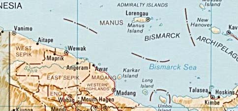
The earthquake occurred approximately 45
miles (70 km) Southeast of Vanimo, New Guinea, PNG, at 08:49
GMT on July 17, 1998 (6:49 PM local time in Papua New Guinea).
According to the National
Earthquake Information Service (NEIS) of the U. S. Geological
Survey, the epicenter was 3.08 S, 141.76 E (about 12 miles offshore).
The depth of focus was less than 33 km and the magnitude was
7.1. A major aftershock followed, less than an hour later.
U.S.G.S Map
of Major Faults in PNG
Earthquake
Source Mechanism
Review of source mechanism
studies of previous shallow focus earthquakes in this region
display a variety of faulting mechanisms. However, most of the
previous earthquake events near the vicinity of the July 17,
1998 event, are along steep dipping reverse faults.
 Source
Mechanism studies of earthquake events east and south of the
July 17, 1998 area, display mostly strike-slip movements. However,
to the west the source mechanisms of earthquakes show mostly
normal faulting. Finally, there is a great deal of similarity
in the mechanism of the 17 July, 1998 earthquake and that which
occured on 14 May 1982. In the vicinity of the July 17, 1998
event, earthquake movements occur along steep dipping reverse
faults. Tsunami effects focusing and orientation - as described
below - indicate an earthquake generation mechanism involving
reversee faulting at least along a localized fracture approximateley
30 km long. Source
Mechanism studies of earthquake events east and south of the
July 17, 1998 area, display mostly strike-slip movements. However,
to the west the source mechanisms of earthquakes show mostly
normal faulting. Finally, there is a great deal of similarity
in the mechanism of the 17 July, 1998 earthquake and that which
occured on 14 May 1982. In the vicinity of the July 17, 1998
event, earthquake movements occur along steep dipping reverse
faults. Tsunami effects focusing and orientation - as described
below - indicate an earthquake generation mechanism involving
reversee faulting at least along a localized fracture approximateley
30 km long.
Such source mechanism
is also in agreement with the focal mechanism solution performed
by the Canadian Seismological Survey. On 3 Oct 1999 Dr. Shutian
Ma contacted the author and provided a full focal mechanism solution
for the July 17 1998 Papua New Guinea quake which can be seen
at http://www.seismo.nrcan.gc.ca/ma/mechanism.htm
Dr. Ma wrote: "My
results have some differences with that of others but have some
similarities with the figure that you drew.
The isotropic part
of the moment tensor is less than zero. If this result is true,
compress effects may be exist near source".
Tensor Analysis -
See also tsunami source mechanism described below.
 Precursor Event Precursor Event
There was one precursor
seismic event in the general area of Papua New Guinea on 4 July
1998 (10:23 42.) The epicenter of this earthquake was ar 4.32
S, 143.52 E. and its magnitude was 5.5
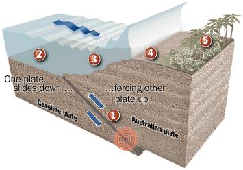
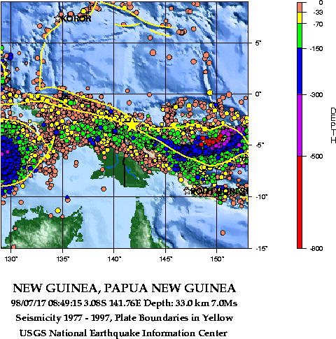
Plate Tectonics
The northen coast off Papua New Guinea,along
the Bismarck Sea where this earthquake occurred, is is a very
active seismic region involving complex interactions and movements
of tectonic plates. This is an area where the smaller Caroline
tectonic plate subtrusts the larger Australian tectonic plate.
Most of the earthquakes along this zone result from strike slip
movements but some occur along steep dipping reverse faults with
vertical components sizable enough to generate destructive local
tsunamis.
Tectonic Plate movements
(as illustrated by the Chicago Tribune)
SEISMICITY
OF PAPUA NEW GUINEA (Showing Tectonic Plate Boundaries)
Source: U.S.
Geological Survey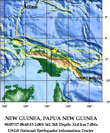
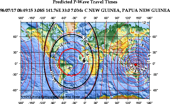
 Travel Times
of Compressional Seismic Waves for the 17 July 1998 PNG Earthquake
(U.S. Geological Survey Map)
Travel Times
of Compressional Seismic Waves for the 17 July 1998 PNG Earthquake
(U.S. Geological Survey Map)
The
Tsunami of 17 July 1998 in Papua - New Guinea
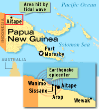 Introduction Introduction
The earthquake of
17 July, 1998, generated a local destructive tsunami. Large tsunami
waves destroyed primarily three fishing villages along a 30 km
stretch of beach west of Atape, in the West Sepik Province of
Papua New Guienea (PNG). Most of the deaths occurred at the villages
on the shores of the Sissano lagoon area (see Photo below).
Minutes after the
earthquake shook the region, three successive tsunami waves battered
the coastal villages causing chaos in the darkness of the early
night. Two of the villages, one on the spit separating the sea
from Sissano lagoon, were completely swept away. 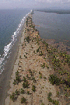 At the Warapu, a village of 1,800
people, and at Arop, a village of 1800-2,000 people, there were
no houses standing. Palm and coconut trees were ripped out completely
by the wave action. At the Warapu, a village of 1,800
people, and at Arop, a village of 1800-2,000 people, there were
no houses standing. Palm and coconut trees were ripped out completely
by the wave action.
Three Large Tsunami
Waves Reported: According
to accounts of survivors, first they felt their homes tremble
as the earthquake shook the seabed. Approximately one minute
later, at 6:50 p.m., they heard a roar described "like a
jet fighter landing". In the next few minutes, three huge
waves, the largest estimated at 10 meters (more than 30 feet)
high, slammed the coastline. The waves swept men, women and children
into the sea. Most of the victims were children. The waves were
followed by a brief lull then a fourth less violent wave arrived.
By 7.07 pm, approximately 18 minutes after the earthquake, the
sea was quiet again. (Photo
of Sissano Lagoon)
Tsunami Effects: The villages on the slender
spit of land which separates the Sissano lagoon from the sea
completely disappeared. A priest's house was picked up and swept
200 meters (600 feet) inland. Paul Saroya, a survivor who lost
eight members of his family commented: "We just saw the
sea rise up and it came toward the village and we had to run
for our lives"
Tsunami Source
Mechanism
Based on seismic and
reported tsunami wave data, on review of source mechanism studies
of previous shallow focus earthquakes in this region, the following
observations can be made about the source mechanism of this tsunami.
Tectonic Source Motions: The mechanism of tsunami generation
was primarily the result of subthrusting of the Caroline tectonic
plate underneath the Australian plate. As described above, most
of the historical earthquakes in the area display a variety of
faulting mechanisms but mainly are of the strike-slip or normal
faulting variety. However, in the vicinity of the July 17, 1998
event, earthquake movements occur along steep dipping reverse
faults.
Review of preliminary
centroid, moment tensor solutions of the PNG earthquake of 17
July 1998, and of historical earthquake data, also support such
coupled motion. Such displacements are much more efficient in
producing destructive tsunamis. Fortunately, fracturing of the
tectonic plates appears to limit the length of faulting and thus
the occurence of larger earthquakes and tsunamis. This accounts
for greater earthquake frequency and therefore an increase of
the tsunami risk. However, most earthquakes occurring in this
area, although capable of producing catastrophic tsunamis locally,
and would not be expected to produce destructive Pacific-wide
tsunamis (small tsunami activity may be recorded by distant tide
gauge stations.)
Tensor Analysis of
the July 17, 1998 Earthquake (Canadian National Resources)
Recently Dr. Shutian
Ma of the National Resources, Ottawa, Canada (personal communnication-
Oct 99) estimated the focal
mechanism of
the 1998-07-17 Papua New Guinea quake and found similarities
wich support the proposed earthquake and tsunami source mechanism.
According to Dr. Ma the isotropic part of the
moment tensor is
less than zero. If this result is true, compress effects may
exist near the source. Such compress effects would indeed cause
steeper dipping reverse faulting resulting in a localized tsunami
of greater height - in this case, for approximately 30 km.
 Tsunami Generating
Area Tsunami Generating
Area
AFP photo of Sissano
Lagoon
Because of the localized
destructiveness of the July 17, 1998 PNG tsunami and the fact
that most of its effects were concentrated along only a 30 km
portion of the coast line, we must conclude that the tsunami
had a relatively small generating area. This generating area
can be approximated by an ellipsoid approximately 30 to 35 km
long and perhaps as much as 15 km wide, with its major axis approximately
paralleling the 30 km stretch of beach west of Atape in the West
Sepik Province of PNG (see
agreement above with tensor analysis results by Dr. Ma). Based on these approximations,
the total tsunami generating area is estimated at less than 400
square kilometers. The absence of extensive damage elsewhere,
supports this estimate.
Vertical
Crustal Displacements, Volume and Energy
Average vertical
displacement of the ocean floor is estimated to be in the order
of about 2 meters. The total volume of displaced material is
estimated at approximately 7-8 cubic kms - indeed a very small
amount for Pacific-wide tsuanmi generation. However, the preliminary
estimate given here, does not include the volume of sediments
which may have been moved as a result of underwater landslides.
Also, it remains to be established to what degree such underwater
landslides of loose sediments may have contributed to the destructiveness
of the tsunami. Finally, the energy of the earthquake and that
which went into tsunami generation, remains to be calculated.
Tsunami
Wave Periods
The tsunami-affected
region was well within the tsunami generating region, which accounts
for the short travel time and the short period of the destructive
waves. As reported by survivors, travel time for the first destructive
wave was approximately one minute. A total of four waves were
observed all within an 18 minute time span, which means that
the period of the tsunami waves was extremely short, averaging
about 4 minutes. The short period may be indicative of the deeper
water depth in the offshore area. Bathymetric charts show such
deep water which could account for the shorter periods, considering
also the small size of the generating area. Also, the bathymetric
data indicates a sharp slope gradient where underwater landlsides
may have been generated, which may have contributed to the destructiveness
of the sea waves.
Slumping
and Underwater Slides
It is not known to
what extent slumping and underwater slides contributed to tsuanmi
generation. The bathymetry and the process of sedimentation in
the area must be studied. Slumping and landslides may very well
be part of the source mechanism that contributed to the destructive
waves, as was the case with the 1946 Alaska tsunami. Sediment
slumping made the 1946 tsunami much more destructive than what
it would have been otherwise. The geology of Sissano Lagoon and
the spit in front of it, suggest extensive sedimentation which
must extend into the sea.
Height of
the Tsunami
There is evidence
that the offshore slope in the vicinity of Aitape has a steep
gradient which could have contributed to the extreme height of
the tsunami. This view is shared by the
Tsunami Laboratory
of the Russian Academy of Sciences which provides a map of the
bathymetry just offshore of the northern coast of New Guinea,
commenting on this very steep slope.
 Conclusions Conclusions
The spit in front
of Sissano Lagoon where the fishing villages were situated, is
an area very similar to San Juan island, a spit in the state
of Narino, in Colombia , where a similar catastrophic tsunami
occurred in 1979, killing many people. In Colombia, the situation
was very similar to PNG - fishing villages were situated on low-lying
coastal areas. The tsunami effects at San Juan island were very
similar to those of Aitape in PNG. There was also a lagoon on
the other side of a San Juan Island - an elongated coastal spit.
The tsunami travel time of the 1979 tsunami in Colombia was a
little longer, so there was opportunity for evacuation. However,
same as in Sissano Lagoon, there was no safe area to evacuate
to. As in Sissano, maximum land elevation was about 3 meters,
and there was no higher ground to escape. The tsunami in Colombia
was only 3 meters, but many lives were lost at San Juan and at
Charco. If refuge platforms had been built for vertical evacuation,
many lives would have been saved. The death toll would not have
been as high for this 1979 Colombian tsunami, nor for the Moro
Gulf tsunami in the Phillipines, which in 1976 killed more than
10,000 people. Preparedness, a program of public education on
the tsunami hazards, and Refuge Platforms for vertical evacuation
may be the most effective way in saving lives in PNG for similar
coastal areas, when the next tsunami disaster strikes.
References
Abers, G., and R.
McCaffrey, 1988. Active
deformation in the New Guinea fold-and-thrust belt: Seismological
evidence for strike-slip faulting and basement-involved thrusting, J. Geophys. Res., v. 93, p.
13,332-13,354.
Everingham, I.B.,
1974. Large earthquakes
in the New Guinea-Solomon Islands area, 1873-1972, Tectonophysics, v. 23, p. 322-338.
Geist, E. L., 1998.
Local tsunamis and
earthquake source parameters,
Advances in Geophysics, v. 39, p. 117-209.
Maternovskaya Natasha
, Centroid, Moment
Tensor Solution, PNG Earthquake of 17 July 1998, Harvard Event - File C071798A
Pararas-Carayannis,
George. Five Year
Plan for The Development of A Regional Warning System in the
Southwest Pacific.
A Report prepared to the United Nations Development Program (UNDP),
New York, May 1989, 21 p.
Pararas-Carayannis,
George, Survey of
Philippine Earthquake and Tsunami of August 16. 1976, ITIC Report 1976. "Severe
Earthquake and Tsunami Hit the Philippines, August 16, 1976.
Abstracted article, Tsunami Newsletter , Vol. IX, No. 3, September,
1976.
Pararas-Carayannis,
George. International
Tsunami Information Center A Progress Report For 1974-1976. International Coordination
Group for the Tsunami Warning System in the Pacific, Vina Del
Mar, Chile, 1977.
Pararas-Carayannis,
George, Indonesian
Earthquake and Tsunami of August 19, 1977, Intern. Tsunami Information Center Report,
Abstracted article in Tsunami Newsletter, Vol. X, No. 3, September,
1977.
Pararas-Carayannis,
George, Survey of
the Earthquake and Tsunami of December 12, 1979, in Colombia. Intern. Tsunami Information
Center Report, Abstracted article in Tsunami Newsletter, Vol.
XIII, No. 1, January, 1980.
Smith, W. H. F., and
Sandwell, D. T., Science, v. 277, p. 1956.
Additional
Information on this Page
RECENT INQUIRIES AND QUESTIONS FREQUENTLY ASKED
ABOUT THE PNG TSUNAMI OF 17 JULY 1998
Links to other
Web Sites
Additional
documentation of the July 17, 1998 Papua New Guinea Tsunami can
be found at the following web sites.
Tsunami
Laboratory of the Russian Academy of Sciences
National Oceanic and Atmospheric Administration
(NOAA.) (Tide gauge records)
National Earthquake Information Center (NEIC) (Eartquake Data)
Return to

  Links to other
Pages
Links to other
Pages

 Now available
from Amazon, Barnes and Noble and other major bookstores. A signed
by the author copy can be also ordered by contacting directly
by email Aston
Forbes Press.
Now available
from Amazon, Barnes and Noble and other major bookstores. A signed
by the author copy can be also ordered by contacting directly
by email Aston
Forbes Press.
 Other
Miscellaneous Non-technical Writings
Other
Miscellaneous Non-technical Writings
(©) Copyright
1963-2007 George Pararas-Carayannis / all rights reserved / Information
on this site is for viewing and personal information only - protected
by copyright. Any unauthorized use or reproduction of material
from this site without written permission is prohibited.
|