|
Tsunamis
of the Indian Ocean
George
Pararas-Carayannis
Copyright © 2005. All Rights
Reserved

Introduction
Although
not as frequent as in the Pacific Ocean, tsunamis generated in
the Indian Ocean pose a great threat to all the countries of
the region. The most vulnerable are: Indonesia, Thailand, India,
Shri Lanka, Pakistan, Iran, Malaysia, Myanmar, Maldives, Somalia,
Bangladesh, Kenya, Madagaskar, Mauritius, Oman, Reunion Island
(France), Seychelles, South Africa, and Australia.
The Great
Earthquake of December 26, 2004 off the west coast of Northern
Sumatra generated the most devastating tsunami in history. It
killed more than 225,000 people with thousands more reported
missing and left unprecedented devastation along its path across
the Bay of Bengal and the entire Indian Ocean.
Although
not as destructive as the 26 December 2004 event was, many more
tsunamis have been generated by large earthquakes in subduction
zones bordering the Indian Ocean and by smaller magnitude events
along the Central Indian and Carlsberg mid-oceanic ridges. The
recent historical record shows that major tsunamis occurred in
1524, 1762, 1819, 1847, 1881, 1941, 1945, 1977 and in 2004. Additionally,
the 26 August 1883 Ultra Plinian eruption and collapse of the
Krakatau (Krakatoa) volcano in the Sunda Strait - between Java
and Sumatra - generated the best known and documented tsunami
in recorded history. This particular tsunami killed 37,000 people
in the islands of Java and Sumatra. There may be additional destructive
tsunamis in the Indian Ocean that have not been properly documented.
For example villagers of Simeulue Island , off the coast of Sumatra,
speak of a destructive tsunami in 1907 that had killed thousands
of people.

 Seismotectonics of
the Indian Ocean Region - Potential Tsunami Generating Sources Seismotectonics of
the Indian Ocean Region - Potential Tsunami Generating Sources
The following
is only a brief overview of the tectonic setting and interactions
that result in tsunamigenic earthquakes in the Indian Ocean.
The India
tectonic plate has been drifting and moving in a north/northeast
direction, for millions of years colliding with the Eurasian
tectonic plate and forming the Himalayan
mountains.
USGS graphic
showing the migration of the Indian tectonic plate
As a result
of such migration and collision with both the Australian and
the Eurasian tectonic plates and subplates, the Indian plate's
eastern boundary is a diffuse zone of seismicity and deformation,
characterized by extensive faulting and numerous earthquakes
that can generate destructive tsunamis.
To the west,
similar interaction of the India plate with the Arabian and Iranian
microplates of the Eurasian block, has created an active subduction
zone along the Makran coast of Pakistan. A major fault in this
region has produced several tsunamigenic earthquakes recently
and in the distant geologic past. This major fault is of the
same character as the West Coast fault along the coast of Maharashtra,
India - which is also a region that can produce tsunamigenic
earthquakes. Further south on the western side the Indian tectonic
plate is bounded by the Central Indian and Carlsberg mid-ocean
ridges, a region of shallow seismicity.
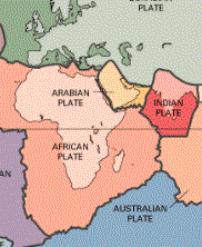 To
the east, subduction of the Indo-Australian Plates beneath the
Burma and Sunda Plates has formed the extensive Sunda Trench
- a very active sismic region where large earthquakes are frequent.
The volcanoes of Krakatau, Tambora and Toba , well known for
their violent eruptions, are byproducts of such tectonic interactions.
A divergent boundary separates the Burma plate from the Sunda
plate in the north. The Burma plate encompasses the northwest
portion of the island of Sumatra as well as the Andaman and the
Nicobar Islands, which separate the Andaman Sea from the Indian
Ocean. To
the east, subduction of the Indo-Australian Plates beneath the
Burma and Sunda Plates has formed the extensive Sunda Trench
- a very active sismic region where large earthquakes are frequent.
The volcanoes of Krakatau, Tambora and Toba , well known for
their violent eruptions, are byproducts of such tectonic interactions.
A divergent boundary separates the Burma plate from the Sunda
plate in the north. The Burma plate encompasses the northwest
portion of the island of Sumatra as well as the Andaman and the
Nicobar Islands, which separate the Andaman Sea from the Indian
Ocean.
Destructive
tsunamis can originate from earthquakes that occur along these
principal tectonic sources . The major tectonic feature in the
region is the Sunda Arc that extends approximately 5,600 km between
the Andaman Islands in the northwest and the Banda Arc in the
east. The Sunda Arc consists of three primary segments; the Sumatra
segment, the Sunda Strait Segment and the Java Segment. These
locations represent the area of greatest seismic exposure, with
maximum earthquake magnitudes of up to 7.75 or even more on the
Richter scale - as the 26 December 2004 proved.
According
to recent studies reported in the Earth and Planetary Science
Letters (vol 133), the Indo-Australian plate does not appear
to be coherent. The two plates appear to have separated many
million years ago. Also, it appears that the Australian plate
is rotating in a counterclockwise direction, putting stress on
the southern segment of the India plate.
The movement
of the Australian plate can generate earthquakes along the southern
end of western Sumatra, along the Sunda Strait segment of the
great tectonic arc, or further east along the Java segment, off
the Lesser Sunda Islands or at Flores Island of Indonesia. Active
tectonic interaction in this eastern section of the great arc
has produced destructive earthquakes and tsunamis in the distant
past and as recently as 1977, 1992 and 1994.
Smaller
magnitude earthquakes along the mid-Indian ocean ridge have the
potential of generating smaller local tsunamis. Finally, deltaic
sediment accumulations of major rivers have also the potential
of generating tsunamis. Such landslides can be triggered even
by earthquakes of lesser magnitude.
British
Geological Survey graphic of the seismicity of Southern Asia
of the Carlsberg Midoceanic Ridge and of the southern portion
of the Arabian Peninsula and the Red Sea.

Recent
Tsunamis of the Indian Ocean
(partial
listing - being updated)
Although
not as frequent as in the Pacifc, destructive earthquakes and
tsunamis have occurred in the Indian Ocean troughout geologic
history and in recent times. Most of these events have not been
adequately documented, leading to the erroneous impression by
many that tsunamis do not occur often enough to present a risk
that requires the establishment of a Regional Tsunami Warning
System in the Indian Ocean.
However,
the destruction and high death toll caused by the 26 December
2004 tsunami disaster indicates how underestimated this hazard
has been - especially by the countries that were so adversely
afflicted. Although not frequent , major tsunamis have occurred
in the Indian Ocean. At least eight of these were major events,
which have been documented - but some not adequtely . Of course,
one of these was the well-known catastrophic tsunami generated
from the ultra Plinian eruption of Krakatau on 26 August, 1883.
The tsunami waves reached over 30 meters and killed about 37,000
people in Java and Sumatra.
Other major
tsunamis occurred in 1524, 1762, 1819, 1847, 1881, 1941, 1945
and in 1977. Less destructive tsunamis have also occurred more
recently. The following is a summary of only a few of the historical
Indian Ocean tsunamis (Further information on Indian Ocean earthquakes
and tsunamis will be provided with subsequent updates).
The Earthquake
and Tsunami of 31 Dec 1881 in the Andaman Sea
A major
earthquake (with estimated Richter magnitude of 7.9 ) in the
vicinity of Car Nicobar island, in the Andaman Sea, generated
a destructive tsunami which must affected the entire Andaman
and Nicobar island group, and quite possibly the entire Bay of
Bengal region. Waves of 1 meter height were recorded by a tide
gauge station at Chennai, on the East coast of India. Additional
documentation will be provided with a later update
The Earthquake
and Tsunami of 26 June 1941 in the Andaman Sea
On June 26,
1941 (11:52:03 UTC), a devastating earthquake (Mw 7.7 ,
Mb 8.0, Ms 7.7) occurred in the Andaman Sea. Its epicenter was
at 12.50 degrees North and 92.57 degrees East - about 9 degrees
North of the epicenter of the 26 December 2004 earthquake, but
within its tsunami generating area. This was the greatest earthquake
in the Andaman and Nicobar Islands since the 31 December 1881
earthquake (M7.9) in the Nicobar Islands.
The 1941
earthquake was particularly destructive in the Middle and South
Andaman Islands and caused considerable damage at Port Blair,
Port Anson and surrounding areas. The earthquake ground motions
were strong enough to be felt along the eastern coast of India,
in Calcutta (now Kolkata), Chandernagar, Cuttack, Madras (now
Chennai), in Colombo, Sri Lanka , and at Syhlet in Bangladesh.
A series of strong aftershoks (two with magnitude 6.0 ) occurred
within 24 hours of the main earthquake. Fourteen more earthquake
aftershocks with magnitude 6.0 occurred until January 1942.
The earthquake
generated a tsunami in the Bay of Bengal, but no estimates of
wave heights are available According to reports, more than 5,000
people were killed on the east coast of India. The media incorrectly
attributed the deaths and damage to storm surges rather than
to a tsunami generated by an earthquake. Many more deaths must
have occurred elsewhere but were not reported. World War II was
in progress and communications were poor. Because of the war,
losses of lives in remote areas from disasters did not get as
much attention or media coverage. It is suspected that this tsunami
caused many more deaths than what was reported. This event remains
to be further investigated.
 The Earthquake and
Tsunami of 28 November 1945 in the Northern Arabian Sea The Earthquake and
Tsunami of 28 November 1945 in the Northern Arabian Sea
A great
earthquake with moment magnitude Mw 8.0 (Richter Ms 7.8), occurred
on 28 November 1945 (21:56 UTC) off the Makran coast of Pakistan.
Its epicenter was at 24.5 N 63.0 E in the northern Arabian Sea,
about 100 km south of Karachi. The earthquake generated a very
destructive tsunami which affected Pakistan, the western coast
of India, Iran and Oman, killing thousands of people and causing
a great deal of destruction.
The tsunami
was genetated along an active subduction zone off the Makran
coast of Pakistan. This zone marks the boundary between the Arabian
plate sliding beneath the Iranian micro-plate. A major fault
which runs along the Makran coast is believed to be of the same
character as the West Coast fault along the coast of Maharashtra,
India.
The region
of subduction along the Makran coast of Pakistan and the Gujarat
Region of India where major earthquakes have occurred - one as
recently as 2001.
PAKISTAN
- The tsunami
waves reached a maximum height of 40 feet along the Makran coast
destroying fishing villages and causing great damage to port
facilities. More than 4,000 people died from the combined earthquake
and tsunami along the Makran coast, but most of the deaths were
caused by the tsunami.
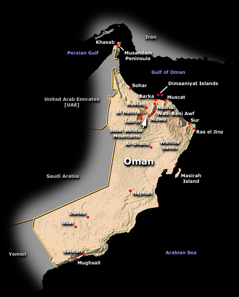 Tsunami waves of about
6.5 feet in height struck Karachi. There was no damage to the
port and boats in Karachi Harbour. According to reports, the
waves completely destroyed and killed all the people of the fishing
village of Khudi, some 30 miles west of Karachi. There
was considerable destruction and loss of life at the towns of
Pasni and Ormara. Tsunami waves of about
6.5 feet in height struck Karachi. There was no damage to the
port and boats in Karachi Harbour. According to reports, the
waves completely destroyed and killed all the people of the fishing
village of Khudi, some 30 miles west of Karachi. There
was considerable destruction and loss of life at the towns of
Pasni and Ormara.
IRAN - There was considerable
loss of life and destruction but no details are available.
INDIA - There was extensive
destruction and loss of life along the west coast of India {(Salsette
Island , Versova (Andheri), Haji Ali (Mahalaxmi), Juhu (Ville
Parle) and Danda (Khar)}. The tsunami waves reached a height
of 11.0 - 11.5 meters in Kutch, Gujarat. In Mumbai the height
of the tsunami was 2 meters. The waves were recorded in Bombay
Harbor but did not cause damage.
OMAN - There was considerable
loss of life and destruction but no details are available. The
tsunami was recorded at Muscat and Gwadar.
Future destructive
tsunamis in the region could be generated from earthquakes along
the subduction zone off the Makran coast or from a a major thrust
fault along parts of deltaic Indus river.
(Excerpts
from unpublished report by G. Pararas-Carayannis, "Seismo-Dynamics
of Compressional Tectonic Collision - Potential for Tsunamigenesis
Along Boundaries of the Indian, Eurasian and Arabian Plates"
(Abstract submitted to the International Conference HAZARDS 2004,
Hyderabad, India, 2-4 Dec. 2004 )
The Earthquake
and Tsunami of 19 August 1977 in Indonesia - (Source: George Pararas-Carayannis 1977 survey
in ITIC and ISU reports and Newsletters)
On August
19, 1977 (06:08:52.2 UTC) a major earthquake {Magnitude: 8.22
(Mw), 8.1 (Ms), 8.9 (ML)} occurred in the Java Trench, westward
of Sumba Island in Indonesia. This was the strongest earthquake
in the Indian Ocean in several decades.The epicenter was 170
kilometers SSW of Pradapare (Sumba Island), at 11.09 S, 118.46
W. The quake was very widely felt and caused people in Perth,
Australia, more than 2000 Km southward, to flee from office buildings.
A major tsunami was generated which struck the coast of Sumba,
Sumbawa, Lombok and Bali. In Kuta - Bali, one person was killed
and 5 houses collapsed, 26 boats were broken or missing. On Lombok,
20 persons were killed, 115 houses damaged, 132 boats missing
or broken. On Sumbawa, 81 people were killed, 53 people missing,
more than 1000 people lost their properties, 63 houses, one school
building, one mosque collapsed and the other was cracked. The
quake also caused damage to some office buildings, school buildings,
a mosque and a market in Sumbawa and Bima. In the entire Nusa
Tenggara Islands region, the quake caused 107 deaths, with 54
people missing, 440 houses damaged/collapsed, 467 boats missing
or broken, 5 school buildings collapsed and 3 teachers houses
damaged.
 The Lesser Sunda Islands
where the 19 August 1977 Earthquake and Tsunami Occurred The Lesser Sunda Islands
where the 19 August 1977 Earthquake and Tsunami Occurred
Coastal
roads did not exist in 1977 along the shores of the Lesser Sumba
Islands fronting the Java Trench, but with the exception of Sumbawa
some communities could be reached by road from the interior.
Thus, no major ports were in the seriously struck areas, and
casualties were relatively low. Incomplete reports indicated
that more than 180 people died or presumed to be dead and that
3900 were left homeless. Property losses included homes, fishing
boats, and gear. No tide records were available for most areas
in Indonesia. However, on an inaccessible section of Sumbawa
Island, a preliminary study indicated that the waves reached
at least 15 meters above high tide, and penetrated about 500
meters inland in some valleys. Accounts given of the tsunami
by observers at several locations have reasonable consistency.
The tsunami
arrived on the Indonesian coast about an hour or two after high
water, and begun with a recession that exposed the beach for
100-200 meters. Three large waves followed at intervals of perhaps
5 minutes or less, the first being the highest and most destructive.
Residents in Sumbawa and Lombok communities reported that that
before the quake and the tsunami arrival up to 3 unusual explosive
sounds were heard over a period estimated from a few seconds
to a minute or more. The sounds were described as those of bombs,
of aircraft breaking the sound barrier, or thunder. The sound
in each case came more or less from the direction of the earthquake's
epicenter at sea. Almost every community reported the water turning
black, and some claimed also that it increased in temperature
and bad a bad odor.
Three
major waves reportedly struck along the Australian coast ,the
first being the largest, as in Indonesia. The sea level disturbances
continued for several hours. The wave height was 2 meters at
Dampier, 2 to 4 meters at Port Sampson, and 6 meters at Cape
Leveque. The tsunami arrived as the tide was falling and, at
most places, it was near low - which fortunately reduced the
tsunami impact. There was apparently no loss of life in Australia,
though it was reported that at least one person was swept into
the sea by the waves.
|

