As previously stated, sudden and massive flank
failures are extremely rare phenomena. There is evidence that
the flanks of island stratovolcanoes fail, but there is no scientific
consensus on why or how this happens. Furthermore, there is no
valid geologic evidence documenting that prehistoric collapses
generated mega tsunamis with significant far-field effects. The
recent numerical studies (Ward & Day, 2001; Ward 2001) forecasting
mega tsunami generation from recurrences of large massive volcanic
island flank failures, are based on unrealistic assumptions of
present slope instability of Cumbre Vieja on La Palma and Kilauea
in Hawaii, of source dimensions, of speed of failure, and of
tsunami coupling mechanisms. Incorrect treatment of input parameters
and of wave energy propagation and dispersion, produced incorrect
estimates of near and far field terminal effects - thus overstating
the tsunami threat.
In order to evaluate the threat of mega tsunami generation from
the postulated massive flank failures, we much review the assumptions
and input functions used by the recent modeling studies. First,
we will examine if massive volcanic collapses are possible at
the present time and if they can occur, as postulated. Subsequently,
we will review if the models developed correctly the necessary
input functions, and if proper coupling mechanisms were used
to arrive at the source dimensions and initial modeling parameters.
Then, we will examine if realistic input conditions were properly
applied in calculating wave travel, energy distribution, geographical
spreading and dispersive effects, and in forecasting near and
far field tsunami heights. Finally, in assessing the validity
of the above numerical models, we would need verification with
historical events. Historical tsunami runup data can help assess
on whether effects of spatial and temporal coherency were taken
into consideration by these models, and generally evaluate model
performance and prediction capability - for both near and far
field effects. Unfortunately, this cannot be done as massive
flank failures of volcanic island stratovolcanoes are extremely
rare events. Purported deposits of paleo-tsunami runup activity
on the islands of Lanai, Molokai and elsewhere (McMurtrya et
al. 1999), are of questionable validity. Therefore, comparisons
will be made with some recent historical events, for which there
is data.
Present
volcanic flank instabilities and past collapses.
The recent numerical
studies (Ward & Day, 2001, Ward 2001) - forecasting mega
tsunami generation - are based on incorrect assumption that the
underwater flanks of the Cumbre Vieja and Kilauea volcanoes are
extremely unstable and that massive failures can occur in the
near future.
Indeed, in the distant geologic past, massive slides occurred
in the Canary, Cape Verde and Hawaiian islands as well as elsewhere
in the Atlantic, Pacific and Indian oceans. Prehistoric, massive
landslides and flank failures of oceanic island stratovolcanoes
have been extensively studied and documented in the scientific
literature (Moore et al, 1989, 1994, 1995; Moore & Clague
1992; Lipman, 1995; Moore & Chadwick, 1995; Clague et al.,
1998; Carracedo et al. 1999; Dartnell & Gardner, 1999; Day
et al. 1999; Day et al. 1999b; Mehl & Schmincke, 1999; Moss
et al., 1999; Rileya et al 1999; Smith et al. 1999; Stillman,
1999). However, the mechanisms of prehistoric volcanic flank
failures are not fully understood and are still under scientific
investigation.
More frequently, stratovolcanoes appear to slide fairly easily
along the bases - often aseismically.
Generally the movement is continuous. However, occasional locking
has been responsible for some rather large slope failures and
destructive earthquakes. When the failures occur suddenly, they
are not particularly massive. Although local destructive tsunamis
are often generated, within historic times, volcanic flank failures
have not generated destructive waves for shorelines distant from
the source region.
As with all oceanic island stratovolcanoes, the underwater flanks
of Cumbre Vieja and Kilauea are composed mostly of layers of
pillow lavas, interspersed with smaller volumes of pyroclastics.
Ordinarily, these materials are relatively stable and not susceptible
to massive, monolithic failures. Presently, there is no sufficient
geological evidence to support that La Palma's west flank or
Hawaii's southern flank are critically unstable or that a massive
failure can be expected. However, partial flank failures, as
in 1868 and 1975 in Hawaii, may be expected every two hundred
years or even more frequently (Pararas-Carayannis, 1976a, 1976b).
Flank instability
of La Palma.
The evolution of the
western Canary islands, especially in their earlier stages of
growth, has included giant lateral flank collapses (Carracedo,
et al 1999). La Palma, together with El Hierro and Tenerife,
are the youngest of the western Canary Islands and still in their
active shield volcanic stage, which began almost 7.5 Ma ago (Stillman,
1999), with zones which were subsequently underlain by swarms
of dikes and other minor intrusions (Walker, 1999). La Palma
has rugged topography with peaks rising to several thousand meters.
Figure 2. Relief
Map of the island of La Palma showing the volcanoes of Taburiente,
Cumbre Nueva Cumbre Vieja and the north-south trending rift zone
and secondary faults.
A brief review of
La Palma's geology indicates that it was formed by three stratovolcanoes.
The northern part of the island was formed by the shield volcano
Taburiente, about two million years ago (Figure 2 ). The giant
Caldera de Taburiente, is a large depression 5 km across, with
an area of 30 sq. km, and 2 km deep, increased to this size by
extensive erosion and landslides.
The central and southern
part of La Palma were formed by the two other volcanoes, Cumbre
Nueva and Cumbre Vieja. Giant landslides and erosion during the
past million years have removed more than half of the total sub
aerial volume of La Palma. At least one catastrophic collapse,
the Cumbre Nueva giant landslide, occurred about 560 ka ago.
The collapse removed some 200 km3 of the central-western part
of La Palma, forming a large embayment. (Carracedo, et al., 1999).
Recent eruptive activity on La Palma occurs on Cumbre Vieja,
which has a concentrated volcanic center aligned primarily along
a well-defined, N-S trending rift zone - in which major dike
emplacement has taken place (Stillman, 1999). The structural
reconfiguration of Cumbre Vieja's rift zones - which begun about
20 ka ago - the development and high activity of the dominant
south trending rift, the underlying dike swarms, and surface
changes which followed the 1949 eruption, have led to the conclusion
that the volcano's western flank is presently at an incipient
stage of flank instability (Day et al,1999).

Indeed, Cumbre Vieja's western flank appears to be relatively
unstable. However, and in spite of its apparent instability,
it highly unlikely that a major flank collapse will occur in
the near future - particularly one that could be greater than
the prehistoric Cumbre Nueva landslide, of about 560 ka ago.
Further review of La Palma's geologic structure indicates that
the island is composed of two main rock layers separated at about
427 m above sea level. The lower layer is made of pillow lavas,
cut by basaltic dikes. The thickness of the pillow lavas ranges
from 10 to 350 m. The upper layer consists of basaltic lavas
and pyroclastic rocks. In certain areas, as in the Caldera de
Taburiente, strong erosion over time has resulted in the accumulations
of large volumes of gravels, mixed with basaltic lava flows.
Fig. 3. Reunion
Island in the Indian Ocean and the Piton De La Fournaise volcano
showing extensive erosion, subsidence and an arcuate coastline
suggestive of underwater slope failure.(Source: GEOSAT photos)
Similar erosion, but
to a lesser extent, has taken place also along Cumbre Vieja's
flanks. Therefore, a massive surface failure on Cumbre Vieja's
flank is very unlikely to occur. The existing basaltic flows
and dikes, the latter located within 3 km on the west coast of
the island and extending underwater, would limit significantly
the volume of material of any slope failure, above or below the
water. Surface flank failures on La Palma would have limited
dimensions and would occur, either in a step-like form or contained
by ring dikes - as those observed along the flanks of the Piton
de LaFournaise volcano on Reunion island in the Indian Ocean
(Fig 3 ). As for a massive failure of the western flank along
a deeper detachment surface, there is still not sufficient or
conclusive geologic evidence that it can happen in the near future
- as postulated by the tsunami modeling studies.
Flank instability
of Hawaii.
Review of the submarine
geology of the island of Hawaii, shows evidence of debris avalanches
on the ocean floor along the southwestern flank of the Mauna
Loa volcano. The debris avalanches - composed of large blocks,
pulverized rock, and water - are indicative of large prehistoric
slides. (Moore et al. 1989, 1994; Lipman, 1995; Moore and Chadwick,
1995; Clague et al., 1998; Dartnell and Gardner,1999).
Above water, the slope
of Mauna Loa is unusually steep. There are no large escarpments
or faults to indicate gradual slippage in recent times (Lipman,
1995) . However, gradual subsidence has occurred in the past
along the southern flank. The magnitude 8.0 Kau earthquake of
1868, resulted in extensive subsidence of the southern flank
of Mauna Loa, which also affected the southern flank of Kilauea.

Figure 4. Hawaii's
southern slope showing coastal faults parallel to the east rift
zone of the Kilauea volcano, and the Hilina Slump along which
slope failures have been occurring (Modified after Morgan et
al. 2001).
Review
of the coastal geology along Kilauea's southern flank, indicates
a different pattern of kinematic processes. A number of coastal
fault scarps, some as high as 500 m., parallel the Puna rift
zone and are the tops of an extensive fault zone known as the
Hilina Fault System, along which substantial movement has occurred
in the past (Fig. 4). Large fault blocks are tilted back, by
as much as 8° towards the rift zone, indicating a pattern
of gradual subsidence. This subsidence has created the feature
known as Hilina Slump. Papa`u Seamount is the submarine expression
of the active Hilina Slump (Morgan et al 2001 ) (Fig. 5).
Paleomagnetic
studies of changes in lava flow directions on the Hilina Fault
scarps have helped determine the pattern and speed of subsidence
along the southern flank of Kilauea. In addition to subsidence,
these studies have determined a pattern of counterclockwise rotation,
indicating slippage between blocks, occurring along listric normal
faults ( Riley et al., 1999)

Fig. 5.
Oblique sidescan view of the Papa`u Seamount (Modified after(Smith
et al, 1999)
During the 1990's,
Kilauea appeared to be sliding easily along its base, in a seaward
direction, at an average speed of about 10 cm a year. The aseismic
slip event - which was detected in November 2000 by GPS measurements
along this southern slope - occurred gradually over a 36-hour
period. Although indicative of some degree of instability, the
motions were imperceptible and occurred along the upper slope
of Kilauea's southern flank (Cervelli et al, 2000). Such slow
aseismic movements have probably occurred over thousands of years.
These imperceptible kinematic changes are now being detected
and measured, only because new satellite technology and instrumentation
have made it possible.
In summary, there is no indication that Kilauea's southern flank
is unusually unstable at this time, or that a catastrophic massive,
failure can occur as postulated by the recent tsunami modeling
studies (Ward 2001). The subsidence process on the Hilina Slump
appears to be continuous and gradual. High-resolution side scan
surveys of Kilauea's southern slope (Clague et al 1998; Dartnell
and Gardner 1999) show a number of cuspate normal faults near
the head of the slump, as well as grabens and horsts. These are
indicative of past successive, crustal movements - some associated
with major earthquakes. As documented in a subsequent section,
not even the large earthquakes of 1868 and 1975 were associated
with large-scale slope failures along Hawaii's southern coast.
Neither of these two significant earthquakes generated a destructive
Pacific-wide, mega tsunami (Pararas-Carayannis 1976a, 1976b,
Pararas-Carayannis and Calebaugh, 1977). However, it should be
pointed out that a repeat of the 1975 flank failure and associated
large earthquake, can be expected on the south flank of Kilauea
every 200 years or even more frequently (Pararas-Carayannis,
1976a, 1976b).
 EVALUATION
OF MASSIVE VOLCANIC FLANK FAILURES ALONG DETACHMENT FAULTS
EVALUATION
OF MASSIVE VOLCANIC FLANK FAILURES ALONG DETACHMENT FAULTS
The recent numerical studies (Ward & Day,
2001, Ward 2001) - forecasting mega tsunami generation - are
based on incorrect assumption that the flanks of the Cumbre Vieja
and Kilauea volcanoes are extremely unstable and that massive
failures along detachment surfaces can be expected in the near
future.
As stated, recent research indicates that stratovolcanoes can
move or slide along their bases. The movements are relatively
continuous and result in gradual subsidence and slumps. Much
of this movement appears to take place at the volcano/sea floor
boundary or along parallel zones of weakness inside the volcano.
These zones of weakness are often referred to as detachment faults,
along which limited subsidence often occurs. Occasional locking
and subsequent sudden slippage along these internal zones of
weakness, or near the sea floor base, can cause sudden movements
and large earthquakes. Both La Palma and Hawaii appear to have
such zones of weakness and, as shown, massive flank failures
occurred in the distant past. However, no catastrophic flank
collapses along detachment faults have occurred within recorded
history. Recent flank failures in Hawaii have been limited in
extent. Although Cumbre Vieja, on La Palma, appears to be sliding
in a seaward direction at the present time, the volcano is stable
during inter-eruptive periods. There is no indication that a
massive collapse along a detachment surface will occur when the
volcano again erupts.

Evaluation
of postulated massive flank collapse along a detachment fault
zone on La Palma.
The tsunami modeling
study (Ward & Day, 2001) is based on a massive flank collapse
initiating along a detachment fault on La Palma . An extensive
rupture - with maximum offset of 4 meters - along Cumbre Vieja's
crest is the purported surface expression of a major discontinuity
along which the collapse will occur (Figure 3).
As with Kilauea, the Cumbre Vieja volcano appears to be sliding
in a seaward direction. However, contrary to Kilauea - where
palis of up to 500 m in height can be found - there no extensive
fault system paralleling Cumbre Vieja's major N-S trending rift
zone.
Figure 6. Geological
map of La Palma island showing sites of historic eruptions of
the Cumbre Vieja volcano from vents along its north-south trending
rift zone.
Furthermore, there
is no seismic or geologic data to support that the 4 m near-summit
rupture on Cumbre Vieja is indeed the purported zone of weakness
along the western flank - or that it extends to the volcano's
base, as postulated. Indeed the summit rupture resulted in west-facing
normal faulting during the 1949 eruption (Day et al.,1999). Its
geometry and the timing of its formation in relation to episodes
of vent opening during the eruption suggests the possible development
of a discontinuity beneath the volcano's western flank, along
which a collapse or substantial slope failure may occur in the
distant future. However, the apparent seaward displacement measurements
by a ground deformational network and by the Global Positioning
System are within the error-margins of the techniques employed
(Moss et al. 1999). Although the apparent movement vectors do
suggest a coherent westward displacement to the west of the 1949
fault system, the results are not conclusive as to the instability
of Cumbre Vieja's western flank, or that a collapse is imminent.
There is nothing to support that any massive type of failure
will soon occur along this detachment boundary - if indeed it
extends to the volcano's base - as postulated. Further review
of La Palma's geology shows that all of the recent historical
volcanic eruptions on La Palma were associated with about 120
volcanic vents which are distributed along the crest of Cumbre
Vieja's rift zone. In view of this distribution and the absence
of seismic data, it is also conceivable that the near-crest rupture
that developed in 1949, is only a shallow geomorphological feature,
rather than the surface expression of a deeper discontinuity
surface. It may have been caused by superficial gravitational
settling, such as that which forms double step calderas, or from
partial collapses of magmatic chambers that supplied lava to
the numerous vents, along the volcano's north-south trending
rift zone. Furthermore, even if this rupture is indeed a surface
expression of an extensive, deeper discontinuity, there is still
no basis that a flank collapse can occur along this zone of weakness
as a single, massive event. A maximum offset of only 4 meters
cannot be evidence of substantial failure or extreme instability.
In spite of magmatic intrusions from Taburiente's magmatic chamber
to the north, and other than the Cumbre Nueva giant landslide,
of 560 ka ago, none of the known major historical eruptions of
Cumbre Vieja, the latest in 1971, triggered any significant flank
or slope failures (Fig. 6). There is no sufficient data to support
that a major collapse of Cumbre Vieja will occur along the postulated
discontinuity, when the volcano again erupts.
Evaluation
of the postulated massive flank collapse along a detachment fault
zone on Hawaii.
Tsunami modeling by
Ward (2001) is based on the premise of a massive flank failure
along a detachment surface along Kilauea's southern flank in
Hawaii. In contrast to La Palma, in Hawaii there is geologic
evidence of an extensive zone of flank weakness, primarily along
the southern flank of Kilauea. Paralleling the Puna rift zone,
there is an extensive system of coastal faults (palis) which
appear to be gravitational features associated with ongoing subsidence
caused by both seismic and aseismic events - the latter also
documented by recent GPS satellite measurements. There is also
evidence of other parallel submarine volcanic rift zones, formed
in an evolutionary sequence (Reynolds et al. 1998). Marine geophysical
data, including SEA BEAM bathymetry, HAWAII MR1 sidescan, and
seismic reflection profiles, indicate that the southern slope
of Hawaii comprises the three active hot spot volcanoes Mauna
Loa, Kilauea, and Loihi seamount and is the locus of the Hawaiian
hot spot (Smith et al, 1999).
As stated, the Hilina
Slump is the offshore continuation of the mobile Kilauea volcano
south flank and has resulted from subsidence and slope failure
along a deeper detachment surface. The sub-aerial portion of
the slump creeps seaward at a rate of approximately 10 cm/year.
The south flank is characterized mostly by frequent, low-intensity
seismicity. Most of the sudden crustal movements which have generated
strong shallow earthquakes in the past, appear to be triggered
by intrusions and lava movements in the magmatic chambers below
the volcano. However, in spite of the apparent instability, a
massive flank failure of Kilauea along a detachment fault zone
- as postulated (Ward 2001) - is very unlikely to occur. Neither
the 1868 nor the 1975 earthquakes were associated with massive
flank failures of Mauna Loa or Kilauea or generated an ocean-wide
mega tsunami (Pararas-Carayannis 1976a, 1976b, Pararas-Carayannis
and Calebaugh, 1977).
EVALUATION
OF TRIGGERING MECHANISMS OF VOLCANIC FLANK FAILURES AND COLLAPSES
Tsunami modeling (Ward & Day, 2001; Ward,
2001) is based on assumptions that a major volcanic eruption
on La Palma, or a major earthquake in Hawaii, will trigger massive
flank collapses on these islands. There is no mention of what
lateral or vertical forces are needed to initiate the failures.
Also, inferred by the modeling studies are: a) that the triggering
forces act on the center of an unstable flank mass - otherwise
there could not be a monolithic movement; and b) that the unstable
flank mass has monolithic coherence - even though composed of
pillow lavas and loose pyroclastics.
Slope instabilities, slope failures and gravitational flank collapses
of island stratovolcanoes can be caused by different mechanisms,
individually or in combination. Triggering mechanisms may include
isostatic load adjustments, extensive erosion, gaseous pressures,
violent phreatomagmatic eruptions, magmastatic pressures, gravitational
collapse of magmatic chambers, dike and cryptodome intrusions
as well as buildup of hydrothermal and supra hydrostatic pore
fluid pressures.
Basic physics
of slope failure.
Assuming that a massive,
monolithic slope failure of an island can indeed occur along
a deeper "detachment surface", we must still look for
the forces that are needed to trigger it. Review of slope failure
mechanism can only be based on the following considerations (Fig.
7). If only gravity is the acting force, there are two components.
One component is acting perpendicularly to the slope of this
detachment surface, the other is acting tangentially. The perpendicular
component of gravity (gp) holds the potential slide material
(pyroclastics, pillow lavas) in place. The tangential component
of gravity (gt ) causes a shear stress parallel to the slope
- which tends to pull an unstable block in the downslope direction.
If the slope (along which failure can occur) increases, the tangential
component of gravity on that potential mass of slide (gt ) increases,
and the perpendicular component of gravity (gp ) decreases. The
forces resisting downward movement would be shear strength, which
includes frictional resistance and cohesion among the particles
that make up the mass of the potential slide. When the shear
stress becomes greater than the combination of forces holding
the mass of the slide on the slope or along a detachment surface,
then the slide or a collapse are triggered. The failure will
occur more readily on steeper slope angles which increase the
shear stress. Any other external influence that would tend to
reduce shear strength - such as lowering the cohesion among the
particles of the mass or lowering the frictional resistance -
could be a triggering mechanism for the failure.
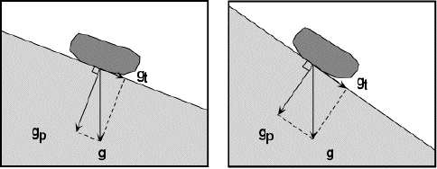 Fig. 7.
Physics of Slope Instability
Fig. 7.
Physics of Slope Instability
The modeling studies
of a La Palma collapse (Ward & Day, 2001) do not comment
on forces needed to overcome the shear strength and mass inertia
of a postulated 500 cubic km block of material, or at which point
of this unstable mass the forces must act to trigger its movement
and subsequent collapse. Since the models treat the initial flank
failure as monolithic, as stated previously, the inference is
that the force of an event - whether a volcanic eruption or an
earthquake - triggers it by acting near the center of the mass.
However this is an unrealistic assumption because for movement
or a collapse to occur, slope failure must initiate closer to
the base of the mass, or at least near the center of mass (if
monolithic) rather than at its upper portion.
Magmatic
chamber collapse mechanism.
Gravitational collapse
of unsupported magmatic chambers can exert shear forces primarily
in the direction parallel to the postulated failure, rather at
the more effective right angle. However massive caldera collapses
are usually associated with violent Strombolian, Surtsean, Plinian
and Ultra-Plinian volcanic eruptions rather than with eruptions
of shield volcanoes. The triggering mechanism of the last violent
paroxysmal eruptive phase of a colossal or super-collosal volcanic
eruption such as those of Krakatau and Santorin, may be hydromagmatic
or the result of extreme gaseous pressures building below high
viscosity magmatic residues. Usually, caldera collapse occurs
by the engulfment of the unsupported upper cone into the drained
magmatic chambers of a volcano after the final paroxysmal phase.
However, in the case
of the Krakatau or Santorin, the estimated volumes of ejected
pumice and other pyroclastic debris were considerably less than
the volumes of the caldera depressions (Pararas-Carayannis, 2002).
The volume discrepancy suggests a possible mechanism for the
explosive removal of the upper volcanic cone, rather than its
total engulfment, or perhaps a combination of the two processes.
Also, the volume discrepancy may be related to the size of empty
magmatic chambers, to lateral material movement, and to adjacent
underwater slope failures. Caldera collapse is not necessarily
a sudden and total process. Often, the collapse process occurs
in phases. This may result in the formation of ring dikes indicating
post-collapse magmatic intrusion along fractures formed by the
subsidence of the roof of the magma chamber.
Regardless of the form or severity of volcanic explosive activity,
collapse processes on any volcano may create large depressions
that resemble Krakatoan calderas, or double pit craters such
as those observed at the summit of shield volcanoes like Kilauea
in Hawaii, or Taburiente on LaPalma. Erosional processes and
slides, as with the extinct Taburiente or Koolau volcanoes, can
contribute significantly to the post-eruption enlargement of
calderas.
There is no evidence of significant magmatic chamber collapse
along the crest of Cumbre Vieja, as the apparent reservoir of
magma appears to be under the Taburiente volcano to the north.
So this does not appear to be a potential mechanism for large
scale flank failure on La Palma. On Kilauea's summit, there is
a large caldera which is indicative of magmatic chamber collapse.
However the present caldera appears to be quite stable. Limited
crater collapses have occurred along Kilauea's rift zone, but
again this is not considered to be an effective mechanism for
triggering any massive type of collapse.
Isostatic
mechanism.
Although the main
force responsible for any slope failure is always gravity, an
event of considerable force is needed to trigger the movement
of a large mass, as postulated. Slope failure due to gravity
alone, is a function of the angle of repose at which the volcanic
materials were deposited as the islands built up. On the flat
ocean floor surface, the force of gravity acts downward, so nothing
moves. On a young volcanic island - still in its shield building
phase - extruded lava flows find their own natural angles of
repose, above and below the water. Excluding the influence of
other forces, underwater slopes of young volcanoes are relatively
stable, consisting mainly of pillow lavas. As a stratovolcanic
island builds up and loads the earth's crust, isostatic adjustments
cause flank subsidence, buckling of the ocean floor, and offshore
deeps and arches. For example, the morphology and structural
evolutionary development of the Hilina Slump, off Kilauea's southern
coast, suggest an active isostatic adjustment process. The Hawaiian
Trough and the Hawaiian Arch are examples of isostatically-caused
buckling of the ocean floor around the island of Hawaii. Although
accountable for the continuous mobility of the volcanic flank,
as observed along the southern coast of Hawaii, this mechanism
is too slow to trigger sudden collapses.
Erosional
mechanism.
As a volcanic island
gets older, extensive erosion takes place. The deposited materials
consist primarily of unconsolidated sediments, gravels, rocks,
pyroclastics, or lavas flows reaching the sea from subsequent
flank or summit eruptions. Where a large accumulation of loose
material occurs, the flank becomes less stable. Gravity alone,
or the vertical and horizontal accelerations of an earthquake,
can trigger landslides.
Erosion during the Miocene period played a key role in the evolution
of Fuerteventura and Lanzarote, the oldest of the easternmost
Canary Islands. Giant landslides reduced them considerably in
height (Stillman, 1999). Even on La Palma, El Hierro and Tenerife,
the younger western islands, which are still in their shield
stage, substantial amount of erosion has occurred. On La Palma,
hundreds of meters of sedimentary material - primarily gravel
- has accumulated on the western slope of the island primarily
due to extensive erosion of the Taburiente caldera. The gravel
is mixed with basaltic lave flows, a trend which appears to continue
into the ocean. A large surface landslide could be triggered
by a large earthquake. However the existing volcanic dikes would
render some stability. Overall the erosion mechanism can be effective
in triggering landslides, particularly on the older islands,
but not on flanks of volcanoes, still in their shield building
stage. Therefore, it is very unlikely that a massive surface
landslide of great dimensions can occur by this mechanism on
either La Palma or Hawaii. In Hawaii, for example, the major
earthquake of 1868 only triggered a surface landslide on Mauna
Loa that was only three miles long and thirty feet thick.
Gaseous
pressure mechanism.
To overcome the shear
strength of 500 cubic km of material on LaPalma, as postulated,
would require a very large triggering event and a tremendous
lateral shear stress. Gaseous pressures do not built up on shield
type of volcanoes as they do prior to the paroxysmal Plinian
and Ultra-Plinian eruptions of the Krakatoan variety. Most of
the eruptions of Cumbre Vieja and Kilauea are non-explosive types
and involve primarily extrusions of pahoehoe and aa lavas, with
only small amounts of pyroclastics, usually from secondary vents.
In the case of La Palma, a major volcanic eruption of Cumbre
Vieja, either near the summit or along vents of its rift zone,
would not build up great gaseous pressures and could not exert
sufficient shear stress to trigger failure at the base of the
postulated mass - most of which is underwater. Recent eruptive
activity on Cumbre Vieja occurs along a concentrated volcanic
center aligned primarily with a well-defined North-South trending
rift zone in which major dike emplacement has taken place (Stillman,
1999). Deformation by intruding magma can indeed create a local
stress field which may result in predominantly dip-slip motion
and form a rupture - as the one resulting from the 1949 eruption.
However, such triggering mechanism will affect the upper portion
of the volcano and can only result in partial flank failure.
Phreatomagmatic
mechanism.
Phreatomagmatic eruption
activity due to ground water intrusion - from increased rainfall
activity caused by climatic changes - has been proposed as another
possible triggering mechanism for volcanic flank failures and
giant landslides (McMurtrya et al. 1999). As the magmatic system
comes into contact with the hydrothermal system, the expansion
of water - in the form of superheated steam - results in an explosive
type of activity that tends to weaken a volcano, perhaps to the
point of collapse. This would be particularly true for continental
type of volcanoes that involve Strombolian, Vulcanian, Peléean
or Plinian type of eruptions, but not so much on oceanic shield
volcanoes. At the latter, phreatomagmatic activity is usually
limited to secondary cone eruptions and the emissions of tephra
or ephritic lava. Furthermore, on oceanic island volcanoes, this
mechanism tends to initiate primarily sub aerial collapses which
may be usually limited to the upper flanks or along secondary
vents along the rift, which may be nearer to the coast.
Additionally, and regardless of climate changes and wetter periods,
relatively young volcanic islands such as Cumbre Vieja and Kilauea
- still in the shield building stage - retain little ground water
because of greater rock porosity. Most of the rain water runs
off and is lost. There is no extensive water lens at the base,
as with older and highly eroded volcanic islands. On the younger
volcanic islands rainfall water collects in pools, surrounded
by impermeable dikes - usually in the upper slopes. Any violent
phreatomagmatic activity is usually limited to a few vents near
the summit or the upper flanks of the volcano and involves only
shallow magmatic chambers. In fact, in 1949, there was a 5-week-long
magmatic and phreatomagmatic eruption activity along Cumbre Vieja's
ridge (White & Schmincke, 1999). There was no evidence of
large scale collapse.
The 1949 eruption begun with emission of ephritic lava from five
vents at the Duraznero crater on the ridge top of Cumbre Vieja
(1880 m above sea level). After these vents shut down abruptly,
activity shifted to an off-rift fissure at the Llano del Banco
crater, located at 550 m lower elevation and 3 km to the northwest.
The new eruptive center emitted initially tephritic aa but later
emissions were basanitic pahoehoe lava (Klügela et al, 1999).
Two days after the initial basanite emissions began at Llano
del Banco, the Hoyo Negro crater (at 1880 m above sea level ),
located 700 m north of the Duraznero crater along the rift, begun
producing ash and bombs of basanitic to phonotephritic composition,
in violent phreatomagmatic explosions (White and Schmincke, 1999).
However, the covariance in the eruption rates of vents that was
observed during Llano del Banco's and Hoyo Negro's simultaneous
phreatomagmatic activity, is indicative of a rather shallow hydraulic
connection and of a limited ground water supply. Other than a
few modifications within the southwestern margins of Hogo Negro's
crater - 50 to 100 m lower (White & Schmincke, 1999), the
phreatomagmatic components of the 1949 eruption did not cause
any large failure of Cumbre Vieja's flank. Similarly, there have
been no large-scale hydromagmatic eruptions on Kilauea and no
landslides of any significance have been generated. In view of
these observations, it can be concluded that phreatomagmatic
activity is limited on active stratovolcanoes and will not cause
massive flank collapses.
Forced dike
injection mechanism.
The forced injection
of dikes and the concurrent development of mechanical and thermal
pore fluid pressures along the upper flank or at the basal décollement
region, combined with associated magmastatic pressures at the
dike interface - as proposed by Elsworth & Day (1999) - can
indeed contribute to significant destabilization of the flank
of an active stratovolcano, such as Cumbre Vieja or Kilauea.
Whether a shallow flank or a deeper basal décollement
failure will eventually be triggered, will depend on additional
complementary destabilizing effects of mechanical magma "piston
like push" at the rear of the weakened block, and the buildup
of thermal and supra hydrostatic pore pressures - if below the
water table. Depending on the geometry and horizontal extent
of dike intrusion and its thickness, as well as on the extent
of contributing hydrothermal and mechanical factors, such combined
forces can indeed become an effective primary triggering mechanism
for larger-scale volcanic flank failures and subsequent tsunami
generation.
There is evidence that large, prehistoric flank failures were
triggered by such mechanisms. Dike and cryptodome intrusion,
as well as hydrothermal alteration in the crater area, probably
weakened and further triggered the flank collapse of the Roque
Nublo stratovolcano on Gran Canaria Island during the Pliocene
period (Mehl & Schmincke, 1999). The massive, prehistoric,
collapse of the Monte Amarelo volcano on Fogo, in the Cape Verde
island group, appears to have been induced by radial rift zones
fed by laterally propagating dikes (Day et al 1999b). More recent
eruption on Fogo, in 1951 and 1995, appear to be associated with
episodes of flank instability caused by now vertically propagating
dikes which manifested in normal faulting near the volcano's
rift zone.
Proper interpretation of seismic data is crucial in making reasonable
predictions of volcanic flank instability associated with forced
dike injection, before or during a major eruption. For example,
seismic data was used successfully to distinguish between brittle
fracture of cold host rock and deformation in the vicinity of
intruding magma for the 1995 Fogo eruption in the Cape Verde
Islands (Heleno da Silva et al., 1999). Based on composite seismic
focal mechanism analysis, the size, depth and direction of the
dike feeding the eruption were identified. From this, an estimate
of the associated stress field was obtained and correlated with
the volcano's flank topography.
Lateral magma migration appears to have occurred on La Palma,
beginning in 1936. Stronger seismic harmonic tremors begun in
early March 1949. Their foci distribution suggests that magma
ascended from chambers beneath the Taburiente volcano and moved
along the north-south-trending rift of Cumbre Vieja (Klügela
et al, 1999). As already mentioned, a major eruption, with phreatomagmatic
activity, begun at Duraznero crater on the ridge top (1880 m
above sea level) on June 24, 1949. The occurrence of xenoliths
almost exclusively near the end of the eruption is indicative
of wall-rock gravitational collapse at depth. The eruption was
associated with subsidence and left a two kilometer-long fracture
near the summit.
The volcanic evolution of the 1949 eruption of Cumbre Vieja seems
to be typical for La Palma. Prior to and during each eruption,
there appears to be considerable shallow magma migration, which
is manifested by strong seismicity, intense faulting, and the
opening of closely spaced vents (Klügela et al, 1999). However,
it should be noted that none of the historic eruptions in 1430/40,
1585, 1646, 1677, 1712, 1949 or in 1971, triggered a large size
slope collapse. on the island. Although the flank of Cumbre Vieja
may have been somewhat destabilized by the 1949 and 1971 eruptions,
there is no indication that a critical condition has been reached,
or that the next major eruption will trigger a massive flank
failure.
In all cases, forced injection of dikes and kryptodomes - and
the concurrent development of mechanical and thermal pore fluid
pressures - appear to result in seaward movement of the volcanic
flank and may eventually result in partial failures of larger
scales. It is believed that mechanical magma intrusion, primarily,
and buildup of thermal and supra hydrostatic pore pressure, secondarily
, are the more effective mechanisms for the sudden and larger
scale volcanic flank failures that can generate local destructive
tsunamis. Such was the apparent mechanism for major past flank
failures of Mauna Loa and Kilauea volcanoes along the southern
coast of Hawaii, and the cause of the 1868 and 1975 earthquakes
- neither of which generate a destructive Pacific-wide mega tsunami
(Pararas-Carayannis, 1976a, 1976b, 2002). Finally, it should
be noted that even the colossal and super-collosal, Plinian and
Ultra-Plinian eruptions of Krakatoa and Santorin volcanoes in
1883 and 1490 B.C. - which were associated with massive flank
failures - generated a mega tsunami that was destructive far
away from the source regions (Pararas-Carayannis, 2002).
EVALUATION
OF SOURCE DIMENSIONS OF POSTULATED FLANK COLLAPSES
The recent tsunami modeling studies (Ward &
Day, 2001, Ward 2001) used unrealistic source dimensions of flank
collapses that are even greater than those of prehistoric events.
The postulated Cumbre Vieja collapse is based on a massive monolithic
slide block 15-20 km wide, 15-25 km long and up to 500 cubic
Km in volume. Similarly unrealistic are the source dimensions
for the postulated flank collapse of Kilauea along Hawaii's southern
coast.
Indeed, there is abundance of geologic evidence indicating that
several large-scale flank collapses have occurred in the distant
past, in the Canary, the Cape Verde, the Hawaiian and other volcanic
islands. The prehistoric flank collapse of the Monte Amarelo
volcano on Fogo island in the Cape Verde archipelago, had an
estimated volume of at least 150-200 km3 (Day et al 1999b). The
Pliocene, flank collapse of the Roque Nublo volcano on Gran Canaria
island left debris deposits of at least 14 km3, covering an area
of about 180 km2, in the southern half of the island (Mehl &
Schmincke, 1999). There was at least one known catastrophic collapse
on La Palma about 560 ka ago. This was the Cumbre Nueva giant
landslide, which removed an estimated 200 km3 of the central-western
of the island, forming a large embayment. (Carracedo, et al 1999).
The Hilina slump is the only large submarine landslide in the
Hawaiian Archipelago thought to be still active. Over millions
of years, the slump is estimated to have covered an area of 2100
km2 and a displacement having a volume of 10,000-12,000 km3 (Smith
et al. 1999). However, its geomorphology indicates that slope
failures occurred from numerous discrete small events, over a
period of time. Also, superimposed on the Hilina slump are horsts
and grabens - indicative of gravitational subsidence and of lateral
pressure effects from dike and cryptodome intrusion originating
from shallow magmatic chambers of Kilauea and Mauna Loa volcanoes.
As discussed in the next section, all of the known historical
earthquakes on the southern part of the island of Hawaii involved
relatively limited slope failures and generated only destructive
local tsunamis in 1823, 1868 and in 1975 (Pararas-Carayannis,
1967, 1976a,b). In 1989, this same region again experienced smaller,
damaging earthquakes, but with limited subsidence and no significant
tsunami generation. Although the overall dimensions of the Hilina
slump are great, the distinct historical episodes of slope failures
had limited dimensions.
The April
2, 1868 slope failure of Mauna Loa.
The most destructive
tsunami of the 19th Century was generated by a local earthquake
(Pararas-Carayannis, 1967, 1975) with an estimated magnitude
of 7.75 (Furumoto, 1966). The shock was felt throughout the Hawaiian
islands, as far as Niihau some 350 miles away. On the island
of Hawaii, strong ground motions triggered a landslide, which
was three miles long and thirty feet thick. The slide swept down
a hill killing thirty-one people and thousands of cattle, sheep,
horses, and goats. Later, on April 28, lava broke out on the
southwest flank of the Mauna Loa volcano and created a 15-mile
flow to the sea.
The 1868 earthquake was associated with considerable subsidence
along the flank of the Mauna Loa volcano. According to Brigham
(1868), the most destructive tsunami effects were observed over
a distance of 50 miles along Hawaii's southern coast. Brigham
could not determine whether the "shoreline has been raised
or depressed" but all indications are that it was depressed,
since the water first recessed before waves inundated the coast.
Tsunami waves struck the coast from Hilo to South Cape, being
most destructive at Keauhou, Puna, and Honuapo; 180 houses were
washed away, and 62 people lost their lives. A 10-foot-high wave
carried wreckage inland 800 feet. At Honuapo all houses were
destroyed. A stone church and other buildings were destroyed
at Punaluu. The place presently known as the Keahou Landing on
the southern part of Hawaii is what Bingham refers in his description
as Keahou. Maximum tsunami wave height there was 65 feet, the
highest observed in Hawaii to date (Pararas-Carayannis, 1967,
1975).
The November
29, 1975 slope failure of Kilauea.
The major earthquake
of November 29, 1975 (surface wave magnitude of 7.2), somewhat
to the east of the area affected by the 1868 event, involved
uplift, subsidence and slope failure. It generated another destructive
local tsunami. Maximum horizontal crustal displacement was approximately
7.9 meters. Near Keauhou Landing, maximum vertical subsidence
was approximately 3.5 meters. The displacements decreased to
the east and west from this area. In fact, subsidence rapidly
decreased to the west. At Punalu'u, the shoreline actually uplifted
by about 10 centimeters (Pararas-Carayannis 1975). Subsequent
surveys determined a subsidence of about 3 meters at Halape Park
to the east. A large coconut grove area adjacent to the beach
subsided by as much as 3.0 and 3.5 meters. Further to the east,
the subsidence decreased to 1.1 meters at Kamoamoa, 0.8 meters
at Kaimu, 0.4 meters at Pohoiki, and 0.25 meters at Kapoho. According
to the Volcano Observatory of the U.S. Geological Survey, even
the summit of Kilauea subsided by about 1.2 meters and moved
towards the ocean by about the same amount. A small, short-lived
eruption took place inside Kilauea's caldera.
The affected offshore block was approximately 70 km long, and
30 km wide with the long axis of the displaced block being parallel
to the coast. This entire offshore region rose approximately
1.2 meters. The total volume of displaced material was roughly
estimated to be only 2.52 cubic km (Pararas-Carayannis 1976a,b).
Furthermore, inspection of tide gauge records showed the initial
wave motion to be upwards at all stations. The significance of
this observation is that the offshore crustal displacement was
an uplift, as the onshore section subsided and moved outward.
This was indicative that the resulting slope failure and earthquake
were not entirely due to gravitational effects of instability,
but may have been partially caused by compressional lateral magma
migration from shallow magmatic chambers of Kilauea. or by lateral
magmastatic forces along an arcuate failure surface or along
a secondary zone of crustal weakness on the upper slope of the
Hilina slump. In fact, recent paleomagnetic studies show that
differential rates of movement and rotation occur between sections
of the slump (Rileya et al., 1999).
Finally, it is interesting to further note that Hilo was greatly
affected by the earthquake shock waves in 1868 and in 1975, but
not by the tsunami waves. This is suggestive of the directionality
of slumping and of the limited dimensions of distinct slope failure
events along the southern flanks of Kilauea and Mauna Loa. Neither
of these two slope failures generated a mega tsunami that posed
a threat at locations distant from the source. Slope failures
and subsidences along Kilauea southern flank have occurred with
frequency. However, the failures appear to have occurred in phases,
over a period of time, and not necessarily as single, large-scale
events, involving great volumes of material.
Slope failures
of the Krakatau and Santorin volcanoes.
Slope failures from
the volcanic explosions of Krakatau in 1883 and Santorin in 1490
B.C. : The violent colossal and super-collosal, Plinian and Ultra-Plinian,
volcanic explosions of Krakatau in 1883 and of Santorin in 1490
B.C. resulted in large caldera and flank collapses. Combined
with atmospheric shock waves, they generated the most destructive
local tsunamis of volcanic origin, in recorded history. Although
the source dimensions and volume of material involved were great,
it should be noted that the flank failures were significant but
not particularly massive.
The explosion/collapse of Krakatoa generated formidable tsunami
waves that were up to 37 m in height. However, the tsunami was
only destructive locally in Indonesia. Only small waves were
recorded away from the source region (Pararas-Carayannis 2002).
Similarly, the great explosion/collapse and flank failures of
Santorin generated a very destructive tsunami estimated to be
40-50 m high near the source area. However, at Jaffa-Tel Aviv,
900 km away, the maximum height of the tsunami had attenuated
to about 7 m tsunami (corrected for eustatic change) (Pararas-Carayannis,
1973, 1992).
EVALUATION
OF SLIDE SPEED
Tsunami
modeling of the La Palma collapse (Ward & Day (2001) is based
on the conjecture that a massive failure of a large crustal block
- up to 500 cubic Km in volume - cascades 60 km out to sea in
only 10 minutes, by rafting on a highly pressurized layer of
mud or fault gouge breccia, before reaching rest at the flat
portion of the ocean, at 4,000 meters. A similarly high slide
speed is used to model tsunami generation from a massive collapse
along Kilauea's Hilina Slump region, in Hawaii (Ward, 2001).
The models treat the slides as monolithic rotations along "detachment
faults", rather than turbulent movements of large size materials,
such as pyroclastics and pillow lavas. The effects of water turbulence
behind the slides' masses, are ignored. It is further assumed
that the slides move, monolithically, for the first 15 km, at
a specified constant velocity of more than 250 km/hour (about
70 -100 m/s).
The models ignore cohesion among the particles of the mass that
would tend to resist movement. The postulated slide speeds of
70-100 m/sec - which have appeared also elsewhere in the the
scientific literature - are based on conjecture. They are unrealistic
as they would already be the speed of a tsunami in 50 m of water
depth. Furthermore, the speed of a tsunami in 50 m is the speed
of potential energy propagating on the surface of the ocean,
while the speed attributed to the slides is that of kinetic energy
along the bottom.
Since the postulated collapses are presumably rotational along
detachment faults, there is also an implicit assumption that
the slope of the failing surface is reduced with depth. However,
the modeling studies do not take into proper consideration the
effect that slope reduction would have on the slide's speed.
Reduction of slope would slow down the slide rather than accelerate
it to 100 m/sec. Large boulders of pillow lavas cannot possibly
move that rapidly. Frictional effects which would tend to slow
down the slide's speed, are overlooked by assuming lubrication
from instantaneously-formed fault gouge breccia.
The speed of flank failure used by the models, is unrealistic.
The maximum speed of the 1929 Grand Banks slide was less than
80 km/h. which is less than the postulated slide speeds used
for La Palma and Hawaii slides. Furthermore, the Grand Banks
slide involved unconsolidated sediments which could move rapidly
downslope as turbidity currents with much less friction (Piper
et al 1988). The mostly, large size particles of pyroclastics
and the pillow lavas of Cumbre Vieja or Kilauea, cannot move
as fast as turbidity currents. Finally, rapid crustal movements,
usually of the upper portion of a stratovolcano's flank, could
only occur along fault fractures triggering an earthquake, dike
intrusion, or a magmatic chamber collapse - either as a linear
features or along a ring dike. Such mechanisms would tend to
limit the extent, dimensions and speeds of a potential slide.
Failures would result either from compressional effects or from
gravitational adjustments. The time history of such failures
would be fairly short in duration. Frictional effects - which
would tend to put the breaks on slides - are disregarded by the
numerical models. Ultimately, the efficiency with which waves
can be generated will depend on how close the slide speed is
to the tsunami speed in that depth of water.
EVALUATION
OF LANDSLIDE COUPLING MECHANISM AND INITIAL TSUNAMI AMPLITUDE
The numerical models (Ward & Day, 2001, Ward
2001) further assume that the initial tsunami amplitude can be
estimated on the basis of being proportional to the vertical
center of a slide's mass displacement (Murty, 1979; Watts 1998,
2000). However this would be a reasonable approximation only
if the slope failure was a monolithic event, and the mass moved
as a unit downslope without disintegrating in the process - and
without taking into consideration the effects of water turbulence
behind the slide or the effects of bottom friction. However,
this is not how slope failures actually occur in nature. Furthermore,
and as mentioned previously, moving 500 cubic Km of material,
as postulated for LaPalma, would require a tremendous triggering
force acting on the center of gravity of a block, and the slide
would need to start from a resting position.
As a result of incorrect assumptions on source dimensions, slope
instabilities and slide speeds, the numerical tsunami models
(Ward & Day, 2001, Ward 2001), overestimate the initial parameters
of slide-to-water coupling. The problem is further exacerbated
by the manner of the numerical computation. For example, in developing
the model's depth grids, depth averaging is used - which is an
acceptable method when used to simplify tsunami generation by
an earthquake. However, this cannot work for landslide failure
mechanism because of differences in time scales. As a slide moves
downslope, water flows around it in the opposite direction. But
depth averaging assumes that slide and water move together, which
leads to an incorrect coupling mechanism in these models.
EVALUATION
OF TSUNAMI FAR-FIELD EFFECTS FROM POSTULATED COLLAPSES OF STRATOVOLCANOES
The combined effects of erroneous assumptions
on source dimensions, source ground motions, speeds and coupling
mechanisms of the La Palma and Kilauea collapse models (Ward
& Day, 2001, Ward 2001) produce initial leading tsunami waves
that are far too high. By treating the resulting tsunami as a
shallow water wave, the models treat incorrectly wave height
attenuation with distance away from the source. The models further
overlook the following basic principles.
Regardless of generative mechanism, there is always scattering
and dispersion of energy over a wider geographical area as tsunami
waves propagate away from a source region. Changes are due to
refraction primarily (large refractive indices tend to produce
correspondingly large dispersions), but geometrical spreading
will also affect tsunami wave heights and, ultimately, runup
at a distant shore. Source dimensions, geometry of the tsunami
generating area and coupling mechanisms, determine the initial
heights and periods of the resulting waves and whether these
will propagate as shallow or intermediate waves. If the wavelengths
are short, dispersion will have a greater effect in attenuating
heights away from the source region. In general, dispersion increases
toward shorter wavelengths, and varies approximately inversely
with the cube of the wavelength.
Also, because of the earth's sphericity, geometric spreading
reduces the wave energy - and wave height - with distance traveled.
The tsunami energy will begin converging again at a distance
of 90 degrees from the source. Geometrical spreading will have
a greater effect for long period tsunami waves. For example,
for two dimensional (X, Z) dispersive tsunami waves, the maximum
height decay with distance is theoretically proportional to*
at great distances from the source. For three-dimensional (r,
S) dispersive tsunami waves, the height-change relationships
with distance conforms to *. The width of such three dimensional
tsunami waves, propagating away from their generating source,
at any time will be:
Where So = widest
wave front at an arcual distance of 90 degrees away from the
source and (Ë) is the great circle distance expressed in
degrees.
For a constant depth ocean, the tsunami amplitude A is related
to:

where S is the width
of the tsunami wave front.
Even though the ocean does not have a constant depth, a first
order approximation of offshore tsunami height with distance
can be obtained, assuming a direct path and only spreading. Also,
the lesser the width of the tsunami wave front and greater the
distance away from the source, the greater will be the wave height
attenuation. Recent modeling studies of tsunami generation from
asteroid impact confirm that the height-change relationships
with distance conforms to *, in accordance to linear dispersive
wave theory (Weaver et al., 2002).
The La Palma and Kilauea collapse models (Ward & Day, 2001,
Ward 2001) treat the resulting tsunami as a shallow water wave
and also produce initial leading tsunami waves that are far too
high. As a result, far field tsunami effects are greatly overestimated.
For example, within two minutes after the postulated La Palma
failure begins (15-25 km wide; mass 500 cubic km.), the model
estimates a water dome 900 meters high on top of the monolithic
slide block. After five minutes, and after traveling 50 km, on
top of the now disintegrating block of material, the leading
wave height drops to 500 meters.
After ten minutes
of travel - when the slide has reaches its rest on the ocean
floor - the leading wave has grown to 250 km in diameter. By
this time, purported mega tsunami waves of several hundred meters
in height have already struck the other Canary islands. The leading
wave of 200 meters propagating away from the source region, is
followed by positive and negative waves that are now 2-3 times
greater - 400 to 600 meters in amplitude. According to the model,
mega tsunami waves of up to 50 m. in height reach Florida and
the Caribbean islands and more than 40 m. the northern coast
of Brazil (See Fig. 2). The modeling of the Kilauea collapse
(Ward 2001), forecasts mega tsunami heights of up to 30 m for
the west coast of North America, and up to 20 m for the southwest
Pacific.
The far field forecasts of these models are erroneous for the
following additional reasons. Even with the overstated source
dimensions, the postulated collapse mechanism can generate only
an initial wave of short wavelength. Maximum period cannot be
more than 3-4 minutes. The wave will behave as an intermediate
rather than a shallow water wave (Mader, 2001). By treating the
resulting tsunami as a shallow water wave, the models only describe
the geometric spreading and not the significant dispersion that
shorter period waves undergo with distance away from the source.
Thus, the models treat incorrectly wave height attenuation. The
wave height is treated as being proportional to the square root
of wave energy. Presumably, as the wave height increases during
the postulated monolithic failure and coupling mechanism, the
mass of water involved in the wave and its height above normal
sea level, increases. Water turbulence behind the mass of the
slide - which would tend to decrease both the energy and the
wave height - is ignored. Essentially such modeling presumes
that, somehow, waves generated from the postulated slides of
LaPalma or Kilauea will increase in energy as they propagate
away from their sources - in other words more energy will be
generated than initially imparted. This is simply not possible.
Another implicit, erroneous assumption is that the wave energy
decreases linearly with distance (in an ocean of constant water
depth), and therefore dispersion will decrease the wave height
with the square root of distance from source - thus much more
slowly than predicted by linear dispersive wave theory. Furthermore,
that this effect of dispersion will only decrease the wave height
by 2/3rd or 3/4th of the root of distance from the source - further
assuming incorrectly that the dominant wavelength increases -so
that the eventual impact of the tsunami wave as it comes ashore
is not so greatly reduced.
Thus, these models forecast incorrectly tsunami far field effects.
Shallow water effects, which are due to the nonlinear nature
of the tsunami, are treated as linear and overestimated. Only
waves of much longer wavelength can propagate effectively across
ocean basins. Even though local destructive tsunami waves can
result from the postulated mechanisms, waves of such short periods
will rapidly decay away from the source region with considerable
height attenuation.
Subsequent modeling by Mader (2001) confirms this and provides
realistic estimates of tsunami far-field effects for the same
hypothetical La Palma slide. Using the wave profile output obtained
from a high speed (110 meters/second), pneumatic landslide generator
of the Swiss Federal Institute of Technology at Zurich, Switzerland
(Fritz, 2001), and based on a "worst case" scenario
for La Palma (650 meter high, 20 kilometer radius water wave
after 30 kilometers of travel), Mader's numerical model treats
the resulting tsunami as an intermediate wave of short wavelength
and period - taking into account both dispersion and geometric
spreading effects. Specifically, the shorter period and wave
amplitudes in his model, result in significant wave height attenuation
with distance - to less than one-third of the shallow water amplitudes.
The upper limit of his modeling study shows that the east coast
of the U.S. and the Caribbean would receive waves less than 3
meters high. The European and African coasts would have waves
less than 10 meters high. However, full Navier-Stokes modeling
of the same La Palma failure, brings the maximum expected tsunami
wave amplitude off the U.S. east coast to about one meter.
SUMMARY
AND CONCLUSIONS - ASSESSMENT OF THE MEGA TSUNAMI THREAT FROM
POSTULATED COLLAPSES OF ISLAND STRATOVOLCANOES
Sudden,
catastrophic, flank collapses of island stratovolcanoes are extremely
rare phenomena and none have occurred within recorded history.
Numerical modeling of mega tsunami generation (Ward &. Day,
2001, Ward 2001) has been based on unrealistic scenarios of massive
flank collapses of volcanoes in La Palma, Canary islands, and
the island of Hawaii.
Indeed, stratovolcanoes
appear to move or slide along their bases. However, most of their
flank movements are relatively continuous and result in gradual
subsidence and slumps - often aseismically. Much of the movements
appear to take place at the volcano/sea floor boundary or along
zones of weakness, paralleling volcanic rift zones. Occasional
locking and subsequent sudden slippage along internal zones of
weakness or near the sea floor base can cause sudden movements
and large earthquakes. However,slope failures occur in phases,
over a long period of time, and not necessarily as single, sudden,
large-scale events.
Most of the sudden
failures in historic times have been limited in extent and did
not involve great volumes of material. They have been shallow
phenomena, usually occurring in the upper flanks, rather than
at the basal decollement region. Overall, subsidences and slides
appear to be triggered by gravitational settling,, by partial
collapses of empty volcanic magmatic chambers, by isostatic adjustment
processes, by magmastatic pressures at the dike interface but,
principally, by the forced injection of dikes and kryptodomes
and the concurrent development of mechanical and thermal pore
fluid pressures along the upper flanks or at the basal décollement
region of stratovolcanoes.
Review of geology and of historic events of LaPalma, does not
support claims that the island's western flank is particularly
unstable or that the next large volcanic eruption of the Cumbre
Vieja volcano will trigger a massive failure along a detachment
fault. There is no seismic data to support that an observed rupture
along the crest of the volcano is the surface expression of a
major weakness zone along which detachment and major failure
can occur in the near future. A summit or flank eruption cannot
exert sufficient shear strength to trigger the movement of up
to 500 cubic km of material - as postulated.
None of the eruptions
of Cumbre Vieja on La Palma in 1646, 1712, 1949 or 1971 triggered
a large size slope collapse or generated a mega tsunami. The
1929 Grand Banks landslide, which involved 300-700 cubic km of
material, generated only a local tsunami with insignificant far-field
effects. The 1958 rockfall that caused the 524 m. impact tsunami
inside Lituya Bay was hardly noticeable outside the source region.
The gigantic Plinian
and Ultra-Plinian volcanic eruptions of Krakatau in 1883 and
of Santorin in 1490 B.C. involved large scale slope failures
and generated catastrophic local mega-tsunamis, but the waves
rapidly decayed as they traveled from the source. The maximum
wave recorded in Batavia (presently known as Jakarta), from the
Krakatau explosion/collapse was only 2.4 meters. The waves at
Jaffa-Tel Aviv in the eastern Mediterranean from the explosion/collapse
of Santorin were only 7 meters high.
A similar review of the geology and of historic events of the
island of Hawaii, does not indicate that Kilauea's southern flank
is unusually unstable or that a massive collapse is possible
in the foreseeable future. None of the strong earthquakes in
Hilo in 1834, in Mauna Loa in 1938, or along the Kona coast in
1951, triggered an underwater slope failure or generated a tsunami.
Neither of the 1868 or the 1975 major earthquakes on the southern
coast of Hawaii resulted in major flank collapses. The slope
failures were large but not massive. Other than local destructive
tsunamis, these two events did not generate destructive waves
at great distances away from the source region. The 1975 tsunami
did cause limited damage to boats on Catalina island, near the
California coast, but no waves of significance occurred there
or anywhere else.
It is extremely unlikely that massive collapses on the islands
of La Palma, or Hawaii will occur in the foreseeable future,
as postulated. The modeling studies forecasting mega tsunami
generation (Ward &. Day, 2001; Ward 2001) are based on erroneous
assumptions of volcanic island slope instabilities, source dimensions,
speed of failure, and tsunami coupling mechanisms. Incorrect
input functions led to inaccurate output estimates as to near
and far field tsunami effects. Even if the collapses occur as
postulated, they can only generate waves of short wavelengths
and periods that will be only locally destructive. These waves
can only behave as intermediate rather than as shallow water
waves. Thus, the models treat incorrectly wave dispersion with
distance and have overestimated greatly the far field effects.
Dispersion will be significantly greater for waves of shorter
periods and wavelengths that can be generated from the postulated
mechanisms - even with the overstated source dimensions. The
waves will rapidly decay and will not be a major threat away
from the source regions.
A collapse of Cumbre Vieja will not generate waves of up to 50
m. in height in Florida and the Caribbean islands, or more than
40 m along the northern coast of Brazil, . Mega tsunami generation
from the postulated collapse of Kilauea is equally unrealistic.
Waves of up to 30 m for the west coast of North America, and
up to 20 m for the southwest Pacific are not possible. Proper
modeling of dispersive effects (Mader 2001) - provides much more
realistic far-field wave estimates, in the unlikely event of
a large-scale, La Palma slope failure. Mader's model of a La
Palma slide estimates that the east coast of the U.S. and the
Caribbean would receive tsunami waves of less than 3 meters and
the European and African coasts would receive waves less than
10 meters high. However, this represents the upper limit. Full
Navier-Stokes modeling brings the maximum expected tsunami wave
amplitude off the U.S. east coast to about one meter. Even with
shoaling effects, a tsunami from a La Palma slide would still
be of concern but does not present an unmanageable threat or
a significant far field hazard.
The threat of mega tsunami generation from collapses of oceanic
island stratovolcanoes has been greatly overstated. No mega tsunamis
can be expected - even if the lateral collapses of Cumbre Vieja
in LaPalma and Kilauea, in Hawaii island occur, as postulated.
Greater source dimensions and longer wave periods are required
to generate tsunami waves that can have significant, far field
effects.
REFERENCES
Carracedo , J. C.
, 1999. Growth,
structure, instability and collapse of Canarian volcanoes and
comparisons with Hawaiian volcanoes.
Journal of Volcanology and Geothermal Research, Vol. 94 (1-4)
(1999) pp. 1-19.
Carracedo, J. C.,
Day S. J. , Guillouc H. and Pérez Torradod F. J., 1999. Giant Quaternary
landslides in the evolution of La Palma and El Hierro, Canary
Islands. Journal
of Volcanology and Geothermal Research, Vol. 94 (1-4) (1999)
pp. 169-190.
Cervelli, et al., 2000.
Sudden aseismic fault slip on the South Flank of Kilauea volcano. (at web site *).
Clague, D. A., Reynolds,
J. R., Maher, N., Hatcher, G., Danforth, W., and Gardner, J.
V., 1998. High-Resolution
Simrad EM300 Multibeam Surveys Near the Hawaiian Islands: Canyons,
Reefs, and Landslides.
EOS, Transactions American Geophysical Union, 79, F826.
Dartnell, P. and J.V.
Gardner (1999). Sea-Floor
Images and Data from Multibeam Surveys in San Francisco Bay,
Southern California, Hawaii, the Gulf of Mexico, and Lake Tahoe,
California-Nevada,
[CD-ROM]. Washington,
D.C.: U.S. Geological Survey (Digital Data Series, DDS-55.Version
1.0).
Day, S.J., J.C. Carracedo,
H. Guillou, and P. Gravestock, 1999. Recent structural evolution of the Cumbre Vieja
volcano, La Palma, Canary Islands. J.
Volcan. Geotherm. Res. 94, 135-167.
Day, S.J., Heleno
da Silvab S.I.N., and Fonsecab, J.F.B.D. 1999b. A past giant lateral collapse
and present-day flank instability of Fogo, Cape Verde Islands. Journal of Volcanology and Geothermal Research,
Vol. 94 (1-4) (1999) pp. 191-218.
ElsworthD., and Day
S.J. 1999. Flank
collapse triggered by intrusion: the Canarian and Cape Verde
Archipelagoes. Journal of Volcanology and Geothermal
Research, Vol. 94 (1-4) (1999) pp. 323-340.
Fritz, H., and Mader
C., 2002, Lituya
Bay Mega-Tsunami.
2nd Tsunami Symposium,
Honolulu, Hawaii, USA, May 28-30, 2002.
Furumoto, A. 1966.
Seismicity of
Hawaii. Bulletin
of the Seismological Society of America, Feb.
Heleno da Silva, S.I.N.
Day S.J. and Fonseca J.F.B.D. 1999. Fogo Volcano, Cape Verde Islands: seismicity-derived
constraints on the mechanism of the 1995 eruption. Journal of Volcanology and Geothermal
Research, Vol. 94 (1-4) (1999) pp. 219-231
Klügela A., Schminckea
H.-U, Whiteb J.D.L., and Hoernlea K.A., 1999. Chronology and volcanology of
the 1949 multi-vent rift-zone eruption on La Palma (Canary Islands). Journal of Volcanology and Geothermal
Research, Vol. 94 (1-4) (1999) pp. 267-282.
Kowalik, Z., 2002. Relationship Between Tsunami
Calculations and Physics.
2nd Tsunami Symposium, Honolulu, Hawaii, USA, May 28-30, 2002.
Lipman, P. W., 1995,
Declining growth
of Mauna Loa during the last 100,000 years: Rates of lava accumulation
vs. gravitational subsidence: in Mauna Loa Revealed. Rhodes, J. M., and Lockwood, J. P., American
Geophysical Union Geophysical Monograph 92, p. 45-80.
Mader C. L. and Fritz,
H. M. 2002, The
Lituya Bay Mega-Tsunami,
2nd Tsunami Symposium,
Honolulu, Hawaii, USA, May 28-30, 2002
Mader C. L., 2001. Modeling the La Palma Landslide
Tsunami. Science
of Tsunami Hazards, Volume 19, pages 150-170 (2001).
Mehl K. W. and Schmincke
H.U, 1999. Structure
and emplacement of the Pliocene Roque Nublo debris avalanche
deposit, Gran Canaria, Spain. Journal of Volcanology and Geothermal Research,
Vol. 94 (1-4) (1999) pp. 105-134.
Moore, J.G., Clague,
D.A., Holcomb, R.T., Lipman, P.W., Normark, W.R., and Torresan,
M.E., 1989., Prodigious
submarine landslides on the Hawaiian Ridge. Journal of Geophysical Research,
Series B 12, Volume 94, p. 17,465-17,484. 94, 17,465-17, 484.
McMurtrya G. M., Herrero-Bervera
E., Cremera M. D., Smith J. R. , Resig J. , Sherman C. and Torresan
M. E., 1999. Stratigraphic
constraints on the timing and emplacement of the Alika 2 giant
Hawaiian submarine landslide. Journal
of Volcanology and Geothermal Research, Vol. 94 (1-4) (1999)
pp. 35-58.
Moore, J.G., and Chadwick,
W.W. Jr., 1995, Offshore
geology of Mauna Loa and adjacent areas, Hawaii.
In Geophysical Monograph 92, Mauna Loa Revealed: structure, composition,
history, and hazards, ed. by J.M. Rhodes and J.P. Lockwood, American
Geophysical Union, Washington, D.C., p. 21-44.
Moore, J.G., and Clague,
D.A., 1992. Volcano
growth and evolution of the island of Hawaii. Geologic Society of America Bulletin, 104, 1471-1484.
Moore, J.G., Normark,
W.R. & Holcomb, R.T., 1994. Giant Hawaiian Landslides. Annual Reviews of Earth and Planetary Science,
22, 119-144.
Morgan, J.K., Moore,
G.F., and Clague, D.A., 2001,
Papa`u Seamount: the submarine expression of the active Hilina
Slump, south flank of Kilauea Volcano, Hawaii. Journal of Geophysical Research, submitted.
Moss, J.L., McGuire
W.J., and Page D. 1999. Ground
deformation monitoring of a potential landslide at La Palma,
Canary Islands. Journal of Volcanology and Geothermal
Research, Vol. 94 (1-4) (1999) pp. 251-265.
Pararas-Carayannis,
G. , 1976a. The
Earthquake and Tsunami of 29 November 1975 in the Hawaiian Islands. ITIC Report, 1976.
Pararas-Carayannis,
G., 1976b. In
International Tsunami Information Center - A Progress Report
For 1974-1976. Fifth Session of the International
Coordination Group for the Tsunami Warning System in the Pacific,
Lima, Peru, 23-27 Feb. 1976
Pararas-Carayannis,
G and Calebaugh P.J., 1977. Catalog
of Tsunamis in Hawaii, Revised
and Updated,
World Data Center A for Solid Earth Geophysics, NOAA, 78 p.,
March 1977.
Pararas-Carayannis,
G, 1988. Risk
Assessment of the Tsunami Hazard. In Natural and Man-Made Hazards, 1988, D. Reidal,
Netherlands, pp.171-181, .
Pararas-Carayannis,
G., 1992. The
Tsunami Generated from the Eruption of the Volcano of Santorin
in the Bronze Age.
Natural Hazards 5::115-123, Kluwer Academic Publishers. Netherlands.
Pararas-Carayannis,
G., 2002. Volcanically
Generated Tsunamis. 2nd Tsunami Symposium,
Honolulu, Hawaii, USA, May 28-30, 2002.
Piper, D.J.W., Shor,
A.N. & Hughes Clarke, J.E., 1988. The 1929 "Grand Banks" earthquake,
slump and turbidity current. Geological Society of America Special Paper
229, 77-92.
Reynolds, J. R., Clague,
D.A., Hatcher, G. and Maher, N., 1998. Evolutionary Sequence of Submarine Volcanic Rift
zones in Hawaii. EOS, Transactions American Geophysical Union, 79, F825.
Rileya C. M. , Diehla,
J. F. Kirschvink J. L. andRipperdanc, R. L. 1999. Paleomagnetic constraints on
fault motion in the Hilina Fault System, south flank of Kilauea
Volcano, Hawaii.
Journal of Volcanology and Geothermal Research, Vol. 94 (1-4)
(1999) pp. 233-249
Shigihara, V., and
Imamura, F., 2002. Numerical Simulation Landslide Tsunami 2nd Tsunami Symposium, Honolulu, Hawaii, USA,
May 28-30, 2002
Smith, J. R. Malahoff
A., and Shor A. N., 1999. Submarine
geology of the Hilina slump and morpho-structural evolution of
Kilauea volcano, Hawaii. Journal of
Volcanology and Geothermal Research, V. 94, No 1-4, 1, pp. 59-88
December
Smith W. H. F. and Sandwell D. T, . 1997,. Global Sea Floor Topography from
Satellite Altimetry and Ship Depth Soundings. Science,
April 7, 1997.
Stillman C.J., 1999.
Giant Miocene
landslides and the evolution of Fuerteventura, Canary Islands. Journal of Volcanology and Geothermal
Research, Vol. 94 (1-4) (1999)
Ward, S. N., 2001. Landslide
Tsunami. J. Geophys.
Res., Accepted and In Press.
Ward, S. N. and S.
Day 2001. Cumbre
Vieja Volcano -- Potential Collapse and Tsunami at La Palma,
Canary Islands.
Geophys. Res. Lett. , Submitted.
Weaver, R., G. Gisler,
G., and M. Gittings, 2002. Asteroid
Generated Tsunamis. 2nd Tsunami Symposium, Honolulu,
Hawaii, USA, May 28-30, 2002
Walker George P.L.,
1999. Volcanic
rift zones and their intrusion swarms.
Journal of Volcanology and Geothermal Research, Vol. 94 (1-4)
(1999) pp. 21-34
White J. D.L. and
Schmincke H-U., 1999. Phreatomagmatic
eruptive and depositional processes during the 1949 eruption
on La Palma (Canary Islands). Journal of Volcanology and Geothermal Research,
Vol. 94 (1-4) (1999) pp. 283-304