|
POTENTIAL
OF TSUNAMI GENERATION ALONG THE MAKRAN SUBDUCTION ZONE IN THE
NORTHERN ARABIAN SEA. CASE STUDY: THE EARTHQUAKE AND TSUNAMI
OF NOVEMBER 28, 1945
George
Pararas-Carayannis
Presentation
at 3rd Tsunami Symposium of the Tsunami Society May 23-25, 2006,
East-West Center, University of Hawaii, Honolulu, Hawaii.

ABSTRACT
Although large earthquakes
along the Makran Subduction Zone are infrequent, the potential
for the generation of destructive tsunamis in the Northern Arabian
Sea cannot be overlooked. It is quite possible that historical
tsunamis in this region have not been properly reported or documented.
Such past tsunamis must have affected Southern Pakistan, India,
Iran, Oman, the Maldives and other countries bordering the Indian
Ocean.
The best known of the historical tsunamis in the region is the
one generated by the great earthquake of November 28, 1945 off
Pakistan's Makran Coast (Balochistan) in the Northern Arabian
Sea. The destructive tsunami killed more than 4,000 people in
Southern Pakistan but also caused great loss of life and devastation
along the coasts of Western India, Iran, Oman and possibly elsewhere.
The seismotectonics of the Makran subduction zone, historical
earthquakes in the region, the recent earthquake of October 8,
2005 in Northern Pakistan, and the great tsunamigenic earthquakes
of December 26, 2004 and March 28, 2005, are indicative of the
active tectonic collision process that is taking place along
the entire southern and southeastern boundary of the Eurasian
plate as it collides with the Indian plate and adjacent microplates.
Tectonic stress transference to other, stress loaded tectonic
regions could trigger tsunamigenic earthquakes in the Northern
Arabian Sea in the future.
The northward movement and subduction of the Oman oceanic lithosphere
beneath the Iranian micro-plate at a very shallow angle and at
the high rate is responsible for active orogenesis and uplift
that has created a belt of highly folded and densely faulted
coastal mountain ridges along the coastal region of Makran, in
both the Balochistan and Sindh provinces. The same tectonic collision
process has created offshore thrust faults. As in the past, large
destructive tsunamigenic earthquakes can occur along major faults
in the east Makran region, near Karachi, as well as along the
western end of the subduction zone. In fact, recent seismic activity
indicates that a large earthquake is possible in the region west
of the 1945 event. Such an earthquake can be expected to generate
a destructive tsunami.
Additionally, the on-going subduction of the two micro-plates
has dragged tertiary marine sediments into an accretionary prism
- thus forming the Makran coastal region, Thick sediments, that
have accumulated along the deltaic coastlines from the erosion
of the Himalayas, particularly along the eastern Sindh region
near the Indus River delta, have the potential to fail and cause
large underwater tsunamigenic slides. Even smaller magnitude
earthquakes could trigger such underwater landslides. Finally,
an earthquake similar to that of 1945 in the Makran zone of subduction,
has the potential of generating a bookshelf type of failure within
the compacted sediments - as that associated with the "silent"
and slow 1992 Nicaragua earthquake - thus contributing to a more
destructive tsunami. In conclusion, the Makran subduction zone
has a relatively high potential for large tsunamigenic earthquakes.

INTRODUCTION
Large earthquakes
along the Makran Subduction Zone (MSZ) have generated destructive
tsunamis in the past (Berninghausen, 1966). Although the historic
record is incomplete, it is believed that tsunamis from this
region had significant impact on several countries bordering
the Northern Arabian Sea and the Indian Ocean. The tsunami generated
along the MSZ on November 28, 1945 was responsible for great
loss of life and destruction along the coasts of Pakistan, Iran,
India and Oman (Qureshi, 2006; Pakistan Meteorological Department
2005; Mokhtari and Farahbod, 2005; Pararas-Carayannis, 2006a).
The effects of this tsunami on other countries bordering the
Indian Ocean have not been adequately documented.
Reports on the potential for tsunami generation along the Makran
coast of Pakistan have been cursory. Based on a thorough review
of recent geophysical surveys and seismic data, the present study
analyzes the potential tsunami generation mechanisms along the
MSZ by reviewing subduction processes of the Oman oceanic lithosphere
underneath the Iranian microplate and - more specifically - the
seismotectonics of the east and west segments, including the
section in the Gulf of Oman. Furthermore, the study examines
the seismo-dynamics of compressional collision of the India and
Eurasia plates along the northwestern boundary of India in the
vicinity of the Northern Arabian Sea - as potential sources of
future tsunamis and evaluates the tsunami risk from major earthquakes
along coastal Karach, the deltaic Indus region and the grabens
of Northwestern India. Finally, the study evaluates the possible
effects of the extensive sedimentation from major rivers in the
region on subduction processes.

THE TSUNAMI OF 28
NOVEMBER 1954 ALONG THE MAKRAN COAST OF PAKISTAN IN THE NORTHERN
ARABIAN SEA
On November 28, 1945,
an earthquake, off Pakistan's Makran Coast (Balochistan) generated
a destructive tsunami in the Northern Arabian Sea and the Indian
Ocean. More than 4,000 people were killed in Pakistan by both
the combined effects of the earthquake and the tsunami. However,
the tsunami was responsible for most of the loss of life and
the great destruction, which occurred along the coasts of Iran,
Oman and northwestern India (Pararas-Carayannis, 2006b).
THE EARTHQUAKE
The great earthquake
occurred at 21:56 UTC (03:26 IST), on 28 November 1945). Its
epicenter was off the Makran coast at 24.5 N 63.0 E (24.2 N,
62.6 E according to USGS, in the northern Arabian Sea, about
100 km south of Karachi and about 87 kms SSW of Churi (Baluchistan),
Pakistan. The quake's focal depth was 25 kms.
The earthquake's Richter Magnitude (Ms) was 7.8. The Moment Magnitude
(Mw) was later given as 7.9 and reevaluated to be 8.1 (Pacheco
and L. Sykes, 1992). The quake was recorded by observatories
in New Delhi, Kolkata (Calcutta) and Kodaikanal. Its intensity
was high throughout the region. It was strongly felt in Baluchistan
and the Las Bela area of Pakistan. It was reported that in the
western and southern sections of Karachi the strong surface motions
lasted for about 30 seconds. According to eyewitness reports,
people were "thrown out of their beds", doors and windows
rattled, and windowpanes broke. The underwater cable link between
Karachi and Muscat (Oman) was damaged, disrupting communications.
The lighthouse at Cape Moze - 45 miles from Karachi - was also
damaged. The earthquake was strongly felt also at Manora, where
the lighthouse was damaged. It was moderately felt in Panjgaur
and Kanpur.
Other Earthquake Effects
The earthquake is
reported to have caused the eruption of a mud volcano a few miles
off the Makran Coast of Pakistan (Wadia, 1981). The eruption
formed four small islands. A large volume of gas emitted at one
of these islands, is reported to have sent flames "hundreds
of meters" into the sky (Times of India 1945; Mathur, S.M.
"Physical Geology of India). Such mud volcanoes are not
uncommon in the Sindh region of the Makran coast. Their presence
indicates the existence of high petroleum deposits. They are
known to discharge flammable gases such as methane, ethane and
traces of other hydrocarbons. The observed flames resulted from
emitted natural gas which caught fire after the earthquake.

Fig 1. The Makran
coast of Pakistan, showing location of the submarine communication
cable cut by the earthquake (after Qureshi, 2006)
Historical Earthquakes
and Tsunamis in the Northern Arabian Sea
Most of the earthquakes
in this region of Southeast Asia occur mainly on land along the
boundaries of the Indian tectonic plate and the Iranian and Afghan
micro-plates. At least 28 earthquakes with magnitudes close to
7 or over 7 are known to have occurred in this region from 1668
to the present time (Ambrasseys and Bilham, 2003). According
to historical records, in 893-894 A.D an earthquake with an estimated
moment magnitude of 7.5 occurred in the Debal (lower Sindh) region
of what is now Pakistan killing 150,000 people and destroying
several towns. There is no data on whether it generated a tsunami.
Also, historic records indicate that a large earthquake in late
October/early November 325 BC generated a tsunamiwhich impacted
the fleet of Alexander the Great, which was in the vicinity of
the Indus river delta at that time (Pararas-Carayannis, 2006a).
THE TSUNAMI
Generating Area of
the 1945 Makran Tsunami
The large earthquake
is believed to have ruptured almost the entire length of the
MSZ's eastern segment. The length of its rupture is estimated
at about 300-350 km. A major tsunami was generated which was
destructive in Pakistan, India, Iran and Oman. The approximate
location and size of the tsunami generating area is shown in
Fig. 1 below.

Fig. 2 The generating
area of the 28 November 1945 tsunami off the Makran coast of
Pakistan.
Effects of the November
28, 1945 Tsunami in Pakistan, India, Iran, and Oman
PAKISTAN - The tsunami reached a maximum
run up height of 13 m (40 feet) along the Makran coast. The waves
destroyed fishing villages and caused great damage to port facilities.
More than 4,000 people died from the combined effects of the
earthquake and the tsunami, but most deaths were caused by the
tsunami. The tsunami destroyed completely Khudi, a fishing village
about 30 miles west of Karachi, killing its entire people. At
Dabo Creek, 12 fishermen were swept out to sea.
Elsewhere along the Makran coast there was considerable destruction
and loss of life. Many people died at the towns of Pasni and
Ormara but no details are available. Many more were washed out
to sea. At Pasni, the waves destroyed government buildings, rest
houses and postal and telegraph facilities. The tsunami was recorded
at Gwadar, but there is no report on damages.
Karachi was struck by waves of about 2 m (6.5 feet) in height.
According to reports the first wave was recorded at 5:30 am local
time, then at 7:00am, 7:15am and finally at 8:15am. The last
wave at 8:15 was the largest. The tsunami arrived from the direction
of Clifton and Ghizri. There was no reported damage to the port
and boats in the harbor of Karachi. However, at Keamari the waves
flooded a couple of compounds along the harbor's oil installations.
INDIA - Waves as high as 11.0 to 11.5
m struck the Kutch region of Gujarat, on the west coast of India,
causing extensive destruction and loss of life. Eyewitnesses
reported that the tsunami came in like a fast rising tide.
The tsunami reached as far south as Mumbai, Bombay Harbor, Versova
(Andheri), Haji Ali (Mahalaxmi), Juhu (Ville Parle) and Danda
(Khar). According to reports the first wave was observed at 8:15am
(local time) on Salsette Island in Mumbai. In Mumbai the height
of the tsunami was 2 meters. Fifteen (15) persons were washed
away. There was no report on damage at Bombay Harbor. Five people
died at Versova (Andheri, Mumbai), and six more at Haji Ali (Mahalaxmi,
Mumbai), Several fishing boats were torn off their moorings at
Danda and Juhu.
IRAN - The tsunami caused extensive
flooding of low-lying areas but no details are available.
OMAN - There was considerable loss of
life and destruction but no details are available. The tsunami
was recorded at Muscat.
THE POTENTIAL OF TSUNAMI
GENERATION ALONG THE MAKRAN SUBDUCTION ZONE AND THE KUTCH GRABEN
IN THE NORTHERN ARABIAN SEA
The active, subduction
zone along the Makran coast of Pakistan and Iran has produced
many tsunamigenic earthquakes in the Northern Arabian Sea in
the past and is a potential source region for future destructive
tsunamis. As demonstrated by the 1945 event, the region is capable
of generating tsunamigenic earthquakes with moment magnitudes
up to Mw 8.1. Also, large earthquakes along the Kutch Graben
of India have caused major sea flooding and destruction of coastal
areas. Extensive sedimentation by major rivers has created unstable
continental slope conditions, so the potential of tsunami generation
from such sources cannot be overlooked. Understanding the seismotectonics
of the region and the subduction processes along the MSZ in particular,
is useful in assessing future large/great earthquakes and tsunami
hazards in the Indian Ocean.
 OVERALL TECTONIC SETTING OVERALL TECTONIC SETTING
 Migration of the Indian tectonic
plate and collision with the Eurasian tectonic plate has developed
a diffuse zone of deformation and seismicity in the entire South
Asia region. Continuous compression due to continent-continent
convergence along the Himalayan arc boundary has resulted in
major thrust or reverse type of faulting which has caused upward
displacement of the Indian plate, the formation of the Himalayan
Mountain Range and the Tibetan Plateau. High compression and
seismic activity characterize the entire tectonic boundary along
both the eastern and western sections of the thrust. Continuing
active collision along the northwestern boundary at the foothills
of the Himalayan mountains caused the destructive October 8,
2005 earthquake in Pakistan (Pararas-Carayannis, 2005). Migration of the Indian tectonic
plate and collision with the Eurasian tectonic plate has developed
a diffuse zone of deformation and seismicity in the entire South
Asia region. Continuous compression due to continent-continent
convergence along the Himalayan arc boundary has resulted in
major thrust or reverse type of faulting which has caused upward
displacement of the Indian plate, the formation of the Himalayan
Mountain Range and the Tibetan Plateau. High compression and
seismic activity characterize the entire tectonic boundary along
both the eastern and western sections of the thrust. Continuing
active collision along the northwestern boundary at the foothills
of the Himalayan mountains caused the destructive October 8,
2005 earthquake in Pakistan (Pararas-Carayannis, 2005).
Fig. 3. The India
tectonic plate has been drifting and moving in a north/northeast
direction, for millions of years colliding with the Eurasian
tectonic plate and forming the Himalayan Mountains. (USGS graphics)
The continental convergence
has further deformed and folded the western boundary, creating
fractured microplates, great faults, large grabens and a major
subduction zone. A complicated pattern of tectonic micro-plates
and areas of both subduction and upthrust characterize the region.
Complex, kinematic earth movements along the boundaries of such
active zones have caused numerous destructive earthquakes in
India, Pakistan, Afghanistan, Iran and Tibet in recent years.
Earthquakes along the Makran Subduction Zone and in the Kutch
Graben region of India are infrequent but have the potential
of generating destructive tsunamis - some with far reaching impact.

Fig. 4 British Geological
Survey graphic of the seismicity of Southern Asia of the Carlsberg
Midoceanic Ridge and of the southern portion of the Arabian Peninsula
and the Red Sea.
MORPHOTECTONICS OF
THE EURASIAN PLATE'S MAKRAN MARGIN
Active tectonic convergence
of the India plate with the Arabian and Iranian microplates at
a rate of about 30 to 50 mm/y (Platt et al. 1985) has created
an extensive and complex tectonic plate margin in Southcentral
Asia along the Makran coasts of Iran and Pakistan. The east-west
oriented complex is one of the largest accretionary wedges on
earth. It is more than 800 km long, bounded to the east and west
by large transform faults which define the plate boundaries.
The present front includes the Makran Subduction Zone (MSZ) and
its associated topographic trench which, to a large extent, is
buried by sediments. Also, the margin includes the Makran Accretionary
Prism (MAP), the Makran Coastal Range (MCR) and the Chegai Volcanic
Arc. To the west of the Accretionary Prism, continental collision
has formed the Zagros fold and thrust belt (Regard et al., 2003).
The Gulf of Oman and the Makran offshore region have been extensively
surveyed over the years with swath mapping, high-resolution and
single-channel reflection seismics, ocean-bottom seismology,
micro-seismicity monitoring, magnetics, gravity and 2D seismic
data collection (GEOMAR, Germany, the University of Cambridge
and the National Institute of Oceanography, Pakistan, - Cruise
(SONNE-123), 1997, 2000; Dorostian & Gheitanchi; Hutchinson
et al 1981).

Fig. 5 Distribution
of earthquake epicenters along the boundaries of the Pakistan,
Afghanistan, Iran and Arabian microplates.
The Makran Subduction
Zone (MSZ)
The Makran Subduction Zone (MSZ) in the Northern Arabian Sea
has been formed by the northward movement of the Oman oceanic
lithosphere and its under thrusting of the Iranian micro-plate
at a very shallow angle of about 20 degrees. The east-west trending
MSZ is more than 800-km-long. The trench associated with the
present accretionary front does not have much of a morphological
relief as other trenches around the world's oceans. A very thick
sedimentary column enters the subduction zone (Closs et al.,
1969, White and Louden, 1983). Extensive erosion of the Himalayan
mountain ranges and the numerous rivers which flow into the North
Arabian Sea have buried the trench with sediments with thickness
of up to 7 km. The deeper structure of the MSZ, the wedge sediments
and the subducted oceanic crust has been surveyed recently by
wide-angle and seismic reflection (Kopp et al., 2000). The effects
of this extensive sedimentation on the seismotectonics of the
region and the potential tsunami generation will be examined
in a subsequent section.
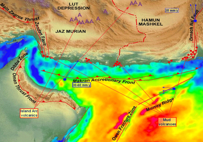
Fig. 6 The Makran
Accretionary Prism and the Zone of Tectonic Subduction in the
Northern Arabian Sea (Modified Dorostian graphic)
The Makran Accretionary
Prism (MAP)
The morphology of
the coastal region is further complicated by the extreme sediment
accretion from the erosion in the Himalayas (Closs et al., 1969,
White and Louden, 1983; Platt et al., 1985; Minshull et al.,
1992, Fruehn et al., 1997). The active tectonic convergence of
the Oman oceanic lithosphere with the Iranian micro-plate has
dragged thick tertiary marine sediments into a very extensive
accretionary prism complex at the southern edge of the Asian
continent (White and Louden, 1983; Platt et al., 1985). Studies
of the morphotectonics of the MAP using swathmapping and 3.5
kHz Parasound echo sounding (Huhn et al., 1998) have provided
a better assessment of the tectonic plate movements and interactions.
The MAP complex is more than 900 km long and it is highly fractured.
It has the same east-west orientation as the MSZ and is bounded
on both sides by large transform faults associated with tectonic
plate boundaries. The MAP is the largest of its kind in the world,
with up to 7 km of sediments deposited in the Gulf of Oman to
the west, and major rivers contributing vast amount of sediment
to the offshore region in the east.
 Fig. 7. Tectonic
compression along the Makran Accretionary Prism has formed an
extensive orocline, The Makran Coastal Range in southern Pakistan.
Fig. 7. Tectonic
compression along the Makran Accretionary Prism has formed an
extensive orocline, The Makran Coastal Range in southern Pakistan.
Along the Balochistan
section of the Makran coast of Pakistan there is less sedimentation.
Several small river deltas have been formed and the continental
shelf of the Arabian Sea in this region measures only 15-40 km
in width. However, in the eastern Sindh region, the Indus River
has formed one of the largest deltas in the world. Past meandering
of Indus have formed extensive deltas east of Karachi and have
altered significantly ancient shorelines. In this region of the
Northern Arabian Sea, extensive sedimentation has widened the
continental shelf to about 150 km.
The Makran Coastal
Range (MCR)
The same active tectonic
convergence of the Oman oceanic lithosphere beneath the Iranian
micro-plate has lifted the tertiary marine sediments into a very
extensive coastal mountain range at the southern edge of the
Asian continent (White and Louden, 1983; Platt et al., 1985).
The Makran Coastal Range (MCR) is a narrow belt of highly folded
and densely faulted mountain ridges which parallel the present
shoreline and extend for about 75 percent of the total coast
length for about 800 km (500 mi) in both the Balochistan and
Sindh Provinces. The steep mountains rise to an elevation of
up to 1,500 m (5,000 ft). The coast is rugged with uplifted terraces,
cliffs and headlands.
The Chegai Volcanic
Arc (CVA)
The same tectonic
mechanism has resulted in the formation of the Chagai volcanic
arc, which extends into Iran on the west and truncates against
the Chaman transform fault on the east. The Koh-e- Sultan volcano
and other volcanic cones in the Chagai area are side products
of this active subduction (Bakht, 2000; Schoppel, 1977). . Koh-e-Sultan
was a formidable volcano once, but it hadn't erupted in 800 years.
However, at the present time there is no evidence of very active
volcanism - as along other tectonic convergence zones - and the
Koh-e-Sultan volcano appears to be in a dormant stage. Even if
volcanoes on the Chegai arc become active again, they are too
far removed from the coast to pose any threat for tsunami generation.

Fig. 8 NASA Satellite
photo of a section of the Makran rugged and tectonic coastline
showing uplifted terraces, headlands, sandy beaches, mud flats,
rocky cliffs, bays and deltas. Numerous mud volcanoes are present
along the shores.
The Kutch, Bombay,
Cambay and Namacia Grabens
East of the Makran
Accretionary Prism and the zone of tectonic subduction, lateral
transition between subduction and collision of the India and
Arabia tectonic plates at about 42mm/yr has formed the Kutch,
Bombay, Cambay and Namacia Grabens, in northwestern India (Wadia,
1981). Although these grabens are not directly related to the
Makran seismotectonics, they are included in this report because
they are potential tsunami sources in the Northern Arabian Sea.
These grabens are bounded by thrust and subsidence faults that
are close to coastal regions, where significant earthquakes occurred
in the past and will occur again in the future. The Kutch graben
region has produced several large earthquakes - the latest in
2001 (Pararas-Carayannis, 2001).
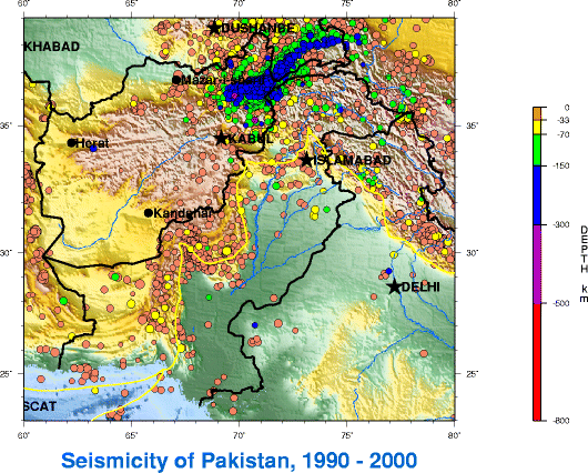 Fig. 9. Seismicity
of Pakistan, 1990-2000 (Pakistan Seismological Agency)
Fig. 9. Seismicity
of Pakistan, 1990-2000 (Pakistan Seismological Agency)
SEISMO-DYNAMICS OF
COMPRESSIONAL COLLISION AND SUBDUCTION AT EURASIA'S SOUTH TECTONIC
MARGIN ALONG THE MAKRAN COASTS OF PAKISTAN AND IRAN
The seismo-dynamics
of the Southcentral Eurasian plate's margin along the Makran
coast are complex because of compressional collision of major
and minor tectonic plates. The entire region is traversed by
thrust and transform faults, formed by great tectonic stresses.
Major and great earthquakes occur with frequency. The following
review of major faults can help identify potential tsunamigenic
sources in the region.
 Major Faults and Potential Tsunamigenic
Source Regions Major Faults and Potential Tsunamigenic
Source Regions
Most of Pakistan's
major faults are on land and most earthquakes occur in the north,
the northwestern and the western sections of the country, along
the boundary of the Indian tectonic plate with the Iranian and
Afghan micro-plates (Quittmeyer and Jacob, 1979; Jadoon, 1992).
Major inland thrust zones exist along the Kirthar, Sulaiman and
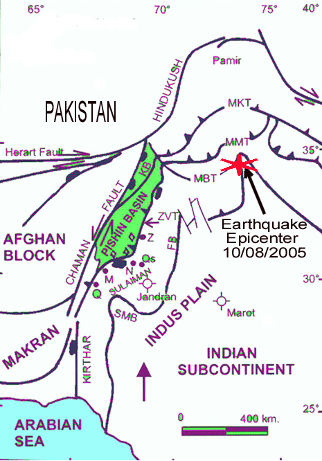
Salt mountain ranges. The devastating October 8, 2005 Earthquake
occurred in the Hazara-Kashmir syntaxial bend - the region of
maximum collision in the north (Pararas-Carayannis, 2005).
Fig. 10 Major faults
in Pakistan
Fewer earthquakes occur along faults near the Makran Continental
Margin. However, some of these earthquakes can be major or great
in magnitude and some have the potential of generating tsunamis
- either by the nature of their tectonic crustal movements or
by the triggering of underwater landslides.
Segmentation of the
Makran Subduction Zone
Deformation along
the entire length of the MSZ appears to be uniform - which indicates
that the rate of subduction does not change appreciably from
east to west. However there is a large change in seismicity,
degree of deformation, as well as significant variations in rupture
histories between the eastern and western MSZ (Minshull et al.,
1992; Dorostian & Gheitanchi). Each region exhibits a different
seismicity pattern. Also, recent geological studies indicate
that two Paleozoic continental blocks dominate the overriding
tectonic plate. The boundary between these two blocks is approximately
coincident with the transition and the differences in seismicity
between the eastern and western MSZ.
Also, recent surveys of the Makra accretionary wedge using swathmapping
and 3.5 kHz Parasound echo sounding (Huhn et al., 1998), indicate
that a sinistral, strike-slip fault crosses the wedge obliquely
and continues to the abyssal plain. The significance of these
findings is that this fault separates the MSZ, into two different
segments - the western which has very low seismicity, from the
eastern where the seismicity is significantly higher. Also, this
unique morphotectonic feature has led to the postulation that
the north-easternmost part of the Arabian plate, is actually
a separate micro plate that moves independently. Two recent shallow
earthquakes in this central region exhibited right-lateral strike-slip
motion, (Dorostian & Gheitanchi, Iran & Institute of
Geophysics, Tehran Univ.) which also supports that there are
two major segments to the MSZ - each behaving differently, but
still capable of generating large tsunamigenic earthquakes. Therefore,
the apparent variation in seismicity between the eastern and
western segments of the MSZ may be due to differences in slip
mechanisms of two different tectonic microplates.
Eastern Segment: The length of the eastern MSZ
segment is estimated at about 350-400 km. Most of the 14 known
earthquakes have occurred along this segment. Of these, only
the great (Mw 8.1) earthquake of 1945 was instrumentally recorded
(Byrne et al. 1992). Also, there appears to be a pattern in seismic
activity prior to major earthquakes on the eastern segment. Large
earthquakes are preceded by increased activity of smaller events.
For example, for ten years prior to the 1945 Makran earthquake,
there was a concentration of seismic activity in the vicinity
of its epicenter.
Western Segment: The western segment of the MSZ
has not generated any known tsunamigenic earthquakes. However,
recent seismic activity indicates that a large earthquake is
possible in the region west of the 1945 event. Such an earthquake
could generate a destructive tsunami.
Since the western segment is an extension of the eastern rupture
of an active subduction zone in a region where major earthquakes
have occurred recently in Iran, Afganistan and Pakistan, its
relative seismic quietness over a long period is somewhat puzzling
and posing several questions. Why has this region remained aseismic?
Is the western segment locked and building stress for a great
event in the future? Is it possible that the western segment
is significantly different from the eastern and experiences largely
aseismic slip at all times? Can an earthquake as great as the
1945 occur along the western segment? Is this segment of the
MSZ a potential source of destructive tsunamis in the North Arabian
Sea and the Indian Ocean? A review of the geophysical and geological
processes and the findings of recent surveys on both segments
of the MSZ can help answer some of these questions and help evaluate
the potential for tsunami generation along the western region.
Comparison of the
Eastern and Western Segments: The
seismodynamics of the western segment of the MSZ are complex.
The presence of late Holocene marine terraces along sections
of the coasts of both eastern and western Makran could be construed
as proof that both segments of the arc are able to produce large
plate boundary earthquakes. The absence of earthquakes along
the plate boundary on the western segment indicates that either
entirely aseismic subduction occurs or that the megathrust plate
boundary is currently locked.
Aseismic deformation has been inferred elsewhere along the north-south
convergence between the plates of Arabia to the south and Eurasia
to the north. For example, earthquake and geodetic data indicate
greater aseismic deformation in the Zagros region in Southern
Iran than that in the Alborz-Kopet-Dag regions of northern Iran,
where deformation results primarily from earthquake activity
(Masson et al., 2005). The implication from these findings is
that aseismic subduction and deformation must also occur south
of the Zagros fault along the western subduction boundary of
the MSZ, in the Gulf of Oman. This could account for the lack
or seismic activity on the western segment of the MSZ. Of course,
this does not mean complete absence of earthquakes along thrust
faults on the western segment of the MSZ and of the MAZ - only
that aseismic deformation occurs most of the time. Occasional
major earthquakes can be expected and these have the potential
to generate tsunamis that could be particularly destructive in
the Gulf of Oman.
EFFECTS OF SEDIMENTATION
ON SUBDUCTION PROCESSES AND THE GENERATION OF TSUNAMIGENIC EARTHQUAKES
A better understanding
of the complex processes of sediment transport and the effect
of sedimentation on shear stresses and interactions along tectonic
boundaries of subduction zones, can lead to improved evaluation
of seismic and tsunami risks. Also, continental slope instability
due to extensive sedimentation from major rivers in the region
adds to the tsunamigenic potential from underwater landslides.
Aside from tectonic stresses, sedimentation may be partly responsible
for the observed differences in seismicity between the eastern
and western segments of the MSZ. Therefore a comparison of the
sedimentary structure of the eastern and western MSZ helps shed
some light on how subduction processes may be affected and the
potential for the generation of tsunamigenic earthquakes.
Effects of Sedimentation
on Aseismic Subduction
As with other subduction
zones, the aseismic region on the entire MSZ lies within that
part of the accretionary wedge that consists of largely unconsolidated
sediments with seismic velocities less than 4.0 km/s. This region
in the overlying accretionary wedge remains aseismic during and
between great earthquakes. Thus, the extensive forearc and accretionary
wedge seem to have significant effects on the type of boundary
slips that can be expected along the MSZ - and thus on the frequency
and intensity of potential tsunamigenic earthquakes in the Northern
Arabian Sea region.

Fig. 11 Major rivers
in Southern Pakistan contribute enormous amounts of sediments
and turbidite deposits
Fine turbidite deposits
in the offshore region may affect the mechanics of subduction
processes near the deformation boundary of the tectonic plates.
As mentioned previously, the subducted oceanic crustal structure
of the MSZ has been partially studied with seismic velocity models
from four wide-angle seismic lines that image the wedge sediments
and with collection of seismic reflection data (Kopp et al. 2000).
The data indicates that fine turbidite sediments bypass the accretionary
ridges and are transported to greater depths offshore and may
be responsible for the sparse earthquake activity associated
with subduction in different segments of the subduction zone.
Such turbidite bypass occurs primarily in the western region.
Essentially, these findings suggest that fine sediments are available
to lubricate the western segment plate boundary sufficiently
to allow slow slippage most of the time. Such mechanism could
account for the suspected aseismic slip of the tectonic plates
along the western segment.
However, if the plate boundary is locked or partially locked,
this would suggest that great earthquakes with long repeat times
might be possible also along the western segment. Based on the
present studies and surveys, it appears that both seismic and
aseismic slips occur along subsegments of the western plate boundary
and that a portion of the western segment may be locked. Furthermore,
the he size of the earthquakes in the western segment - and thus
the potential for tsunami generation - may be limited by other
factors. Because of additional fracturing and segmentation of
the western segment, earthquakes would be expected to have shorter
ruptures and deeper focal depths.
Effects of Sedimentation
on Earthquake Rupture Velocity and Tsunami Generation.
If the above-stated
hypothesis of lubrication by sediments is correct, then the following
explanation can be provided for the seismicity differences between
the eastern and western segments of the MSZ and their potential
for producing tsunamigenic earthquakes. In the eastern segment
of MSZ, thrust earthquakes occur along the plate boundary where
the sediments appear to be more consolidated, dewatered or lithified
and thus, more likely to stick or lock before the stress is released
by an earthquake. The earthquakes appear to be shallower in focal
depth. Also, the consolidated sediments along the plate boundary
would have a tendency to slow the rupture velocity of an earthquake.
Additional, "en echelon", bookshelf type of sediment
failure along an earthquake's rupture zone - would account for
slower rupture velocity and for greater tsunamigenic efficiency.
Such appears to have been the case in the Andaman Sea segment
of the rupture of the December 26, 2004 earthquake along the
Great Sunda Trench. The rupture velocity was much less in the
Andaman Sea segment than in the Sumatra segment - which was not
as heavily sedimented.
Also, such slower rupture occurred along the Mid-America Trench
when the September 2, 1992 Nicaragua tsunamigenic earthquake
struck. It is believed that block motions of consolidated sediments
were associated with bookshelf faulting which contributed to
the slow, silent and deadly tsunami- earthquake. The block motions
were extremely shallow and occurred within subducted sediments
where there was a lot of shear - thus the rupture was slower
in speed (Pararas-Carayannis, 1992). The same slower rupture
occurred in the Andaman Sea segment of the Great Sunda Subduction
Zone in December 2004. In both of these cases, the degree of
sediment consolidation along the plate boundary appears to have
been a key factor in locking slippage on the megathrust region
of the tectonic boundary, then releasing greater energy when
the stress thresholds were exceeded.
The eastern segment of the MSZ appears to behave in a similar
way. There is more sedimentation closer to the Indus and other
major rivers in the east. The sediments are much thicker. The
earthquake rupture velocities would be expected to be slower
and the tsunamigenic efficiency would be expected to be greater
because of potential bookshelf type of fault failures along the
Makran coastal area.
Furthermore, the existence of thrust earthquakes along the MSZ
indicates that either the sediments along the plate boundary
in the eastern segment become sufficiently well consolidated
and dewatered at about 70 km from the deformation front, or that
older, lithified rocks are also present within the forearc so
that stick-slip sliding behavior along the subduction boundary
becomes possible when the stress exceeds a critical level. Thus,
a repeat of a great tsunamigenic earthquake like the 1945 event
is very possible. Earthquake ruptures may be as long as 300 km
long and moment magnitudes could be as much as 8.
In contrast to the eastern segment, the plate boundary along
the western segment of MSZ has not produced great earthquakes
and there have been no recordings of shallow events. Most of
the earthquakes along the western segment occur on the down going
plate at intermediate, rather than shallow depths. This would
suggest that dewatering and lithification of sediments occur
at greater depth along the decollment surface of the plate boundary
and, because of the greater focal depth, such earthquakes would
not be as efficient tsunami generators as those along the eastern
segment. Also, there appears to be much more fracturing along
the western segment, which would suggest that future earthquakes
may have shorter ruptures and lesser magnitudes.
In spite of these observations, a large quantity of unconsolidated
sediments does not necessarily mean a lower potential for great
thrust earthquakes along a subduction boundary. It is rather
the overall structural distribution of consolidated and unconsolidated
sediments along the boundary that become the key factors.
At the present time there is not sufficient data to evaluate
better the effect of sediments on subduction dynamics in this
region. The western segment of the MSZ could produce a great
earthquake but more likely it could rupture as a number of segments
in somewhat smaller-magnitude events. On the basis of the above
evaluation, it can be concluded that the western segment of the
MSZ is a potential source region of infrequent major earthquakes
and potentially destructive local tsunamis. However, because
of the shorter crustal ruptures, earthquakes on the western segment
would not be as great as the 1945 event on the eastern segment.
Maximum expected ruptures would be less than 100 km long and
earhquake magnitudes would be up to 7.
REGIONAL EVALUATION
OF THE POTENTIAL FOR TSUNAMI GENERATION IN THE NORTHERN ARABIAN
SEA
Based on the above
discussion of earthquake data, geology morphotectonics and subduction
processes, the following is a regional assessment of the tsunami
generation potential in the Northern Arabian Sea, and the possible
tsunami near and far- field effects elsewhere in the Indian Ocean.
In addition to the source seismodynamics, a factor that could
also contribute to the destructiveness of a tsunami generated
in the Northern Arabian Sea would be the relatively large astronomical
tide, which is about 3-3.5m (10-11 feet) along the Makran coastline.
A tsunami arriving during high tide at a coast in the northern
Arabian Sea could be expected to be significantly more destructive
because of this high tidal range.
Potential for Tsunami
Generation along the Makran Subduction Zone (MSZ)
Although the Makran
Subduction Zone in the Northern Arabian Sea is an active seismic
zone, large tsunamigenic earthquakes have been relatively rare.
It is quite possible that tsunamis in this region have not properly
reported or documented. A thorough analysis of historical records
may reveal that many tsunamis occurred in the past. Such tsunamis
could have affected Southern Pakistan, India, Iran, Oman, the
Maldives and other countries bordering the Indian Ocean.
Overall, the seismicity of the Makran region is relatively low
compared to the neighboring regions, which have been devastated
regularly by large earthquakes (Jacob and Quittmeyer, 1979).
Although infrequent, major and great earthquakes have occurred
along the MSZ throughout geologic history and in recent times.
Several tsunamis must have been generated in the past along this
active zone but have not been adequately documented. As already
mentioned a large magnitude earthquake generated the oldest known
tsunami in the region in 325 B.C. and not in 326 B.C. as reported
in the literature (Pararas-Carayannis, 2006a). It is believed
that the tsunami destroyed part of Alexander the Great's fleet
while on its journey back to Mesopotamia after the India campaign
(Lietzin 1974, Murty and Bapat, 1999, Pararas-Carayannis, 2006a).
Large tsunamigenic earthquakes can be expected mainly on the
eastern portion of the subduction zone. As previously described,
the great earthquake (Mw 8.1) of November 28, 1945 on the MSZ
generated a very destructive tsunami in the North Arabian Sea.
According to the literature, the earthquake was a thrust event
that ruptured approximately one-fifth of the entire length of
the MSZ, which would be approximately 200 - 250 km. (Byrne et
al. 1992). What was reported may be an underestimate. Although
no centroid solution could be obtained for this event, the revised
moment magnitude of Mw 8.1 would suggest a longer rupture - in
the order of 300-350 Km (Pararas-Carayannis, 2006b). Nine other
smaller earthquakes are known to have occurred in the eastern
Makran with similar thrust mechanisms. The 1945 event's magnitude
of 8.1 appears to be the upper limit of tsunamigenic earthquakes
this region can produce along the plate boundary. The limiting
factors appear to be an apparent segmentation of the MSZ and
the large volumes and spatial distribution of both consolidated
and unconsolidated sediments. The significance of the sediments
to the subduction dynamics was discussed previously. In brief,
tsunamis generated along the eastern segment of the MSZ can be
expected to be destructive in Pakistan and other countries bordering
the Northern Arabian Sea and the Indian Ocean.
Along the western segment, the dynamics of subduction are different.
Although aseismic subduction may be occurring, there are subsections
which may be locked and have the potential to generate earthquakes
with magnitudes up to 7 and local tsunamis along the Makran coast
of Iran and Pakistan as well as along the north coast of Oman.
Potential for Tsunami
Generation along the Makran Accretionary Prism (MAP) from Gas
Hydrate Collapses
The MAP region exhibits high internal deformation, layering and
compaction of sediments (Fruehn et al., 1997). As reported previously,
the 1945 Makran earthquake caused the eruption of a mud volcano
a few miles off the Makran Coast. It was reported that a large
volume of gas was emitted which caught fire and sent flames "hundreds
of meters" into the sky. The observed flames probably resulted
from emitted natural gas, which caught fire after the earthquake.
This event and geologic studies of the MAP stratigraphy (Harms
et al., 1984) indicate that the region has high petroleum deposits,
including gases such as methane, ethane and traces of other hydrocarbons.
The ocean floor of the continental margin along the MAP is thick
with sediments in an oil producing area of the world. The unique
geology, morphology of the sea floor and the thick sedimentary
layers on the MAP region indicate that thick methane gas hydrate
layers must exist in this region. Therefore, the explosion of
gas hydrate deposits has the potential to generate tsunamis or
to trigger submarine landslides that could generate tsunamis
in the region.
Potential for Tsunami
Generation along the Makran Coastal Range (MCR)
The Owen Fault Zone
is a transform fault in the Arabian Sea that is associated with
the active tectonic boundary of the India and Arabia plates.
It extends from the Gulf of Aden in a northeast direction towards
the Makran coast where it enters the coast in the Balochistan
region. Then it continues as a land fault known as the Chaman
Fault - an extensive system that extends in a north-northeast
direction along Pakistan's western frontier with Afghanistan.
The Chaman fault begins near Kalat, in the northern Makran Range,
passes near the city of Quetta and continues to Kabul, Afghanistan.
The Balochistan province in and around Quetta is the region of
highest seismicity. On May 30, 1935, a great earthquake (Mw 8.1)
along this fault destroyed the city of Quetta and killed about
30,000 people (Ramanathan and Mukherji, 1938). Up to the October
8, 2005 earthquake this had been the deadliest in Pakistan. Large
earthquakes along the Owen Fault Zone or the Chaman closer to
the Makran coastal range are infrequent, but have the potential
of generating major earthquakes and tsunamis.

Fig. 12 The Karachi
and Deltaic Indus Region
Potential for Tsunami
Generation along the Karachi and the Deltaic Indus Region
Around Karachi and
other parts of deltaic Indus, there are several thrust faults
which have the potential of generating major earthquakes and
local tsunamis. Unfortunately, most tsunamis in this region have
not been adequately documented.
A major thrust fault
which runs along the southern coast of the Makran coast and parts
of deltaic Indus is believed to be of the same character as the
West Coast fault along the coast of Maharashtra, India. The Allah
Bund is a major fault that traverses Shahbundar, Jah, Pakistan
Steel Mills, and continues to the eastern parts of Karachi -
ending near Cape Monz. This fault has produced many large earthquakes
in the past in the deltaic areas along the coast, causing considerable
destruction. For example, a major earthquake on this fault destroyed
Bhanbhor in the 13th century. Another major earthquake in 1896
was responsible for extensive damage in Shahbundar. There is
no record of whether any tsunamis were generated near the coastal
regions. However, because of the proximity of this fault to sections
of deltaic areas, it is possible that past earthquakes have generated
landslides and local tsunamis.
Another major fault near Karachi is an extension of the one that
begins near Rann of the Kutch region of India. Still another
one is the Pubb fault which ends into the Arabian Sea near the
Makran coast. Finally, a major fault in the lower Dadu district,
near Surajani, is also in the vicinity of Karachi.
In brief, destructive local tsunamis can be generated near Karachi
and the deltaic Indus area because of the proximity of thrust
faults to coastal areas, the nature of crustal movements of major
earthquakes, and the unstable, heavily-sedimented, coastal slopes
of this deltaic region.
 Potential
for Tsunami Generation along the Kutch, Bombay, Cambay and Namacia
Graben Regions of India Potential
for Tsunami Generation along the Kutch, Bombay, Cambay and Namacia
Graben Regions of India
Lateral transition
between subduction and collision of the India and Arabia tectonic
plates has formed the Kutch, Bombay, Cambay and Namacia Grabens,
in northwestern India (Wadia, 1981). In the Kutch region, remote
sensing and gravity investigations have determined a spatial
pattern of tectonic lineaments along which 7 big earthquakes
(M>6) occurred in the last 200 years (Srivastava and Ghosh,
Indian Scool of Mines). Although infrequent, several destructive
earthquakes in the coastal Sindh region occurred in 1524, 1668,
1819, 1901, 1956, and as recently as 25 January 2001 (Pararas-Carayannis,
2001).
 The larger earthquakes involved
extensive vertical crustal uplift over land areas paralleling
the orientation of the Kutch Graben. For example, the 1819 earthquake
in Rann of the Kutch, bordering the Sindh region, was associated
with thrust uplift of up to 30 feet along the Allah Bund fault
and slippage depression of up to 10 feet along coastal fault
plains. Although poorly documented as having generated a tsunami,
the 1819 event was reported as having resulted in major sea inundation,
destruction of coastal settlements, and permanent changes to
the coastline and the drainage of major rivers, such as Indus.
Probably the 1524 earthquake in the same region also resulted
in major inundation by the sea. The larger earthquakes involved
extensive vertical crustal uplift over land areas paralleling
the orientation of the Kutch Graben. For example, the 1819 earthquake
in Rann of the Kutch, bordering the Sindh region, was associated
with thrust uplift of up to 30 feet along the Allah Bund fault
and slippage depression of up to 10 feet along coastal fault
plains. Although poorly documented as having generated a tsunami,
the 1819 event was reported as having resulted in major sea inundation,
destruction of coastal settlements, and permanent changes to
the coastline and the drainage of major rivers, such as Indus.
Probably the 1524 earthquake in the same region also resulted
in major inundation by the sea.
Fig. 13 The Kutch,
Bombay, Cambay and Namacia Graben Regions of India
In conclusion, earthquakes associated with thrust and subsidence
faulting in the coastal region of the Kutch Graben and along
the major fault, which runs along the west coast of Maharashtra,
India, have the potential of generating local tsunamis. Also,
earthquake events on the Kutch Graben have the potential of triggering
undersea landslides and local tsunamis in the offshore region.
The tsunami hazard for this northwest region of India has been
underestimated and needs to be properly evaluated.
SUMMARY AND CONCLUSIONS
Active tectonic convergence
of the India plate with the Arabian and Iranian microplates has
created an extensive and complex tectonic plate margin in Southcentral
Asia along the Makran coasts of Iran and Pakistan. The east-west
oriented tectonic plate margin complex includes one of the largest
accretionary wedges on earth. It is more than 900 km long, bounded
to the east and west by large transform faults which define the
plate boundaries. The present margin includes the Makran Subduction
Zone (MSZ) and its associated topographic trench, the Makran
Accretionary Prism (MAP), the Makran Coastal Range (MCR) and
the Chegai Volcanic Arc. To the west of the MAP, continental
collision has formed the Zagros fold and thrust belt. To the
east, lateral transition between subduction and collision of
the India and Arabia tectonic plates has formed the Kutch, Bombay,
Cambay and Namacia Grabens, of northwestern India. Tsunamis generated
in these regions of the Northern Arabian Sea can have a significant
near and far field impacts.
The MSZ is a relatively active and can produce destructive tsunamigenic
earthquakes. Its seismic history indicates significant variations
in rupture histories primarily in two segments. Large earthquakes
occur mainly on the eastern segment. The earthquake of November
28, 1945 had a moment magnitude Mw 8.1 and a rupture estimated
at about 300-350 km long. It generated a destructive tsunami.
Waves of up to 13 m (40 feet struck Pakistan and waves as high
as 11.5 m struck the Kutch region of India. Waves of 2 m struck
as far south as Mumbai. Also Iran and Oman were struck. The magnitude
of 8.1 of the 1945 event is the upper limit of earthquakes this
region can produce along this plate boundary. The limiting factors
are the apparent segmentation of the MSZ and the large volumes
and spatial distribution of both consolidated and unconsolidated
sediments. The degree of sediment consolidation along the plate
boundary appears to be a key factor in locking slippage on the
megatrhrust region, then releasing greater energy when the stress
thresholds are exceeded.
The sediments are thicker and the continental shelf wider along
the eastern segment of the MSZ because of the proximity to the
Indus and other major rivers. The existence of thrust earthquakes
indicates that either the sediments along the plate boundary
in the eastern segment become sufficiently well consolidated
and dewatered at about 70 km from the deformation front, or that
older, lithified rocks are present within the forearc so that
stick-slip sliding behavior becomes possible when the stress
exceeds a critical level. Thus, great tsunamigenic earthquakes
with magnitudes up to Mw 8 and ruptures of 300-350 km can be
expected to occur in the future.
In contrast, the plate boundary along the western segment of
the MSZ has not produced great earthquakes and there have been
no recordings of shallow events. The present absence of earthquakes
indicates either entirely aseismic subduction or those subsegments
of the megathrust plate boundary are currently locked. It is
more likely that both seismic and aseismic slippage is occurring.
The extensive forearc and accretionary wedge seem to have a significant
effect on the type of boundary slips that can be expected along
or near the western segment - and thus on the frequency and intensity
of potential tsunamigenic earthquakes in this region. Surveys
of the area indicate that the mechanics of subduction processes
near the deformation boundary on the western segment may be affected
by the introduction of fine turbidite deposits which, perhaps,
lubricate the decollment surface of the subduction boundary.
Such deposition and lubrication could account for the aseismic
slip and the sparse earthquake activity along sections of the
western segment of the MSZ.
Also, most of the earthquakes on this segment occur on the downgoing
plate at intermediate, rather than shallow focal depths. This
would suggest that dewatering and lithification of the sediments
occur at greater depth along the decollment surface. Because
of the greater focal depth, such earthquakes would not be as
efficient tsunami generators as those along the eastern segment
that have shallower focal depths The size of earthquakes - and
thus their potential for tsunami generation - may be limited
by other factors. There appears to be much more fracturing along
the western segment of the MSZ. Earthquakes would be expected
to be smaller-magnitude events (less than 7) and to have shorter
ruptures (less than 100 km) along subsegments. In spite of these
observations, a large quantity of unconsolidated sediments does
not necessarily mean a lower potential for great thrust tsunamigenic
earthquakes along a subduction boundary. It is rather the overall
structural distribution of consolidated and unconsolidated sediments
along the boundary that become the key factors. At the present
time there is not sufficient data or surveys to fully evaluate
the effect of sediments on the subduction dynamics of this region.
On the basis of the above evaluation, it can be concluded that
the western segment of the MSZ is a potential source region of
infrequent major earthquakes and of potentially destructive local
tsunamis.
The MAP region is another potential source of local tsunamis.
Its unique geology, morphology of the sea floor, thick sedimentary
layers and its proximity to vast sources of oil and natural gas
deposits indicate the presence of thick methane gas hydrate layers.
Explosion of gas hydrate deposits has the potential to trigger
submarine landslides that could generate local tsunamis.
Another potential source for tsunamis in the North Arabian Sea
is near Karachi and the deltaic Indus. Local tsunamis would be
generated because of the proximity of thrust faults to coastal
areas, the nature of crustal movements of major earthquakes,
and the unstable, heavily-sedimented, coastal slopes of this
deltaic region.
Finally, the Kutch Graben region of India has produced several
large earthquakes in the past and there is a record of extensive
"sea flooding" associated with the 1819 earthquake.
Thus, earthquakes associated with thrust and subsidence faulting
in the coastal region of the Kutch Graben or along a major fault
- which runs along the west coast of Maharashtra - have the potential
of causing tsunamis directly or by triggering undersea landslides.
Similarly further south, thrust and subsidence faults on the
Bombay, Cambay and Namacia Grabens, have the potential to generate
local tsunamis, particularly from landslides triggered by major
earthquakes.
REFERENCES
Ambrasseys, N. and
Bilham, R., 2003, "Earthquakes
and Associated Deformation in North Baluchistan 1892-2001", Bulletin of the Seismological
Society of America, Vol .93, No. 4, p. 1573 - 1605.
Bakht S. M. 2000.
An Overview of Geothermal
Resources of Pakistan.
Proceedings World Geothermal Congress 2000, Kyushu - Tohoku,
Japan, May 28 - June 10, 2000
Berninghausen, W.H.,
1966. "Tsunamis
and Seismic Seiches reported from regions adjacent to the Indian
Ocean", BSSA,
Vol 56, No.1, 1966.
Byrne Daniel E., Sykes
Lynn R. Davis Dan M., 1992. Great
thrust earthquakes and aseismic slip along the plate boundary
of the Makran subduction zone.
JOURNAL OF GEOPHYSICAL RESEARCH, VOL. 97, NO. B1, PAGES 449-478,
1992
Closs, H., Bungenstock,
H., Hinz, K., 1969. Ergebnisse
seismischer Untersuchungen im nrdlichen Arabischen Meer: ein
Beitrag zur internationalen Indischen Ozean Expedition. METEOR Forschungsergebnisse,
Reihe C, 2, 28 pp. Flueh, E. R., Kukowski, N., Reichert, C. (Editors).
FS Sonne Cruise Report SO-123 - MAMUT, Maskat - Maskat 07.09.
- 03.10.1997, GEOMAR Rep. 62, 292 pp.
Dorostian A., Gheitanchi
M. R., Seismicity
of Makran. Report
of College of Science, & Institute of Geophysics, Islamic
Azad Univ. North Tehran Branch, Iran (undated).
Regard V. Bellier
O., Thomas J.-C., Abbassi M.R., Mercier J. L., Shabanian E.,
Feghhi Kh., Soleymani Sh., Bonnet S., Bourlès D. L., Braucher
R., and J. Martinod, 2003. Tectonics
of a Lateral Transition Between Subduction and Collision:The
Zagros-Makran Transfer Deformation Zone (SE IRAN), European Geophysical Society
2003. Geophysical Research Abstracts, Vol. 5, 01210, 2003
Fruehn, J., White,
R. S. and Minshull, T. A., 1997. Internal deformation and compaction of the Makran
accretionary wedge, Terra
Nova, 9: 101-104.
GEOMAR, Germany, the
University of Cambridge and the National Institute of Oceanography,
Pakistan, - Cruise (SONNE-123), 1997, 2000
Huhn K. , Kukowski
N. , Schillhorn T. and E. Flueh, 1998. Morphotectonics of the Makran accretionary wedge
imply new aspects for the plate tectonic situation in the northeast
Indian Ocean. http://www.geomar.de/add_info/former_info/abstracts98/agu98abstracts.html
Harms, J. C., Cappel,
H. N. and Francis, D. C., 1984. The Makran coast of Pakistan: Its stratigraphy
and hydrocarbon potential.
In: Haq, B. U. and Milliman, J. D. (Editors), Marine Geology
and Oceanography of Arabian Sea and Coastal Pakistan: 3-27.
Hutchinson, I., Louden,
K. E., White, R. S., 1981. Heat
flow and age of the Gulf of Oman, Earth Planet. Sci. Lett., 56: 252-262.
Jacob, K. H. and Quittmeyer,
R. L., 1979. The
Makran region of Pakistan and Iran: Trench-arc system with active
plate subduction.
In: Farah, A. and de Jong, K. A. (Editors), Geodynamics of Pakistan:
305-317.
Jadoon, I.A.K., 1992,
"Ocean/continental
transitional crust underneath the Sulaiman Thrust Lobe and an
evoluationary tectonic model for the Indian/Afghan Collision
Zone", Pakistan
Journal of Hydrocarbon Research, v.4, no.2, p.33-45.
Kopp C., Fruehn J.,
Flueh,E. R., Reichert, C., Kukowski N., Bialas J. and D. Klaeschen.
2000. Structure of
the Makran subduction zone from wide-angle and reflection seismic
data. Proceedings,
8th International Symposium on Deep Seismic Profiling of the
Continents and Their Margins, Edited by R. Carbonell, J. Gallart
and M. Torne, Tectonophysics, vol 329 Pages 171-191
Kopp C., Fruehn, J.
Flueh E. and C. Reichert. 1998. Seismic Images of the Makran Subduction Zone
Mathur, S.M. "Physical Geology of India"
Minshull, T. A., White,
R. S., Barton, P. J. and Collier, J. S., 1992. Deformation at plate boundaries around the Gulf
of Oman, Marine Geology,
104: 265-277.
Mokhtari, M. and Farahbod,
A.M. 2005. Tsunami
Occurrence in the Makran Region.
Tsunami Seminar, Tehran, 26 February 2005
Murty. T. and A. Bapat,
1999 "Tsunamis
on the coastlines of India", International Tsunami Symposium, May 1999 (Abstract).
Pacheco and L. Sykes,
1992. "Seismic
Moments of Great Shallow Earthquakes 1900-1990 with Magnitude
> 7", Seismological
Society of America, 1992.
Pararas-Carayannis,
G. 2006a. Alexander
the Great - Impact of the 325 B.C, Tsunami in the North Arabian
Sea Upon his Fleet.
http://drgeorgepc.com/Tsunami325BCIndiaAlexander.html
Pararas-Carayannis,
G. 2006b. The Earthquake
and Tsunami of 28 November 1945 in Southern Pakistan . http://drgeorgepc.com/Tsunami1945Pakistan.html
Pararas-Carayannis,
G., 2005. "The
Earthquake of 8 October 2005 in Northern Pakistan" http://www.drgeorgepc.com/Earthquake2005Pakistan.html
Pararas-Carayannis,
G., 2001, "The
Earthquake of 25 January 2001 in India" http://www.geocities.com/CapeCanaveral/Station/8361/Quake2001India.html
Pararas-Carayaniis,
G. 1992. The Earthquake
and Tsunami of 2 September 1992 in Nicaragua http://drgeorgepc.com/Tsunami1992Nicaragua.html
Platt, J. P., Leggett,
J. K., Young, J., Raza, H. and Alam, S., 1985. Large-scale sediment underplating in the Makran
accretionary prism, Southwest Pakistan, Geology, 13: 507-511.
Quittmeyer, R.C.,
and Jacob, K.H., 1979. "Historical
and Modern Seismicity of Pakistan, Afghanistan, N.W. India and
S.E. Iran,"
Bulletin of the Seismological Society of America, 69/3, pp. 773-823,
1979.
Qureshi R. M. 2006.
Vulnerability of
Pakistan Coast to Tsunami. Possible Applications/Role of Nuclear
Techniques RCARO
Workshop (20 - 24 February, 2006) Daejon, Korea
Masson F., Chery J.,
Hatzfeld D., Martinod J. Vernant P., Tavakoli F., and M. Ghfory-Ashtiani,
2005. Seismic versus
aseismic deformation in Iran inferred from earthquakes and geodetic
data. Geophys. J.
Int. (2005) 160, 217-226
Regard V., Bellier
O., Thomas J.-C., Abbassi M.R., Mercier J. L., Shabanian E.,
Feghhi Kh. , Soleymani Sh. , Bonnet S., Bourlès D. L.,
Braucher R. and J. Martinod, 2003. Tectonics of a Lateral Transition between Subduction
and Collision: The Zagros-Makran Transfer Deformation Zone (SE
Iran), European Geophysical
Society 2003, Geophysical Research Abstracts, Vol. 5, 01210,
2003
Ramanathan, K., and
Mukherji, S., 1938, "A
seismological study of the Baluchistan, Quetta, earthquake of
May 31, 1935",
Records of the Geological Survey of India, Vol. 73, p. 483 -
513.
Schoeppel, R.J., 1977.
Prospects of Geothermal
power in Saindak area, Baluchistan province, Pakistan. Final report for Oil and Gas
Development Co. 15p.
Srivastava V. K. and
Ranjana Ghosh. Mapping
of tectonic lineaments and analysis of earthquake occurrences
in Kutch region of Indian subcontinent using GIS and Remote Sensing
techniques. Report
of the Dept. of Applied Geophysics, Indian School of Mines
Times of India Newspaper
archives (Mumbai), India, November 1945
Wadia, D.N., 1981,
"Geology of
India", Tata-McGraw-Hill,
New Delhi.
White, R. S., Louden,
K. E., 1983. The
Makran Continental Margin: Structure of a Thickly Sedimented
Convergent Plate Boundary.
In: J. S. Watkinsand C. L. Drake (Editors), Studies in Continental
Margin Geology. Mem. Am. Ass. Petrol. Geol. 34: 499-518.
Return to
 
  Links to other
Pages
Links to other
Pages

 Now available
from Amazon, Barnes and Noble and other major bookstores. A signed
by the author copy can be also ordered by contacting directly
by email Aston
Forbes Press.
Now available
from Amazon, Barnes and Noble and other major bookstores. A signed
by the author copy can be also ordered by contacting directly
by email Aston
Forbes Press.
 Other
Miscellaneous Non-technical Writings
Other
Miscellaneous Non-technical Writings
(©) Copyright
1963-2007 George Pararas-Carayannis / all rights reserved / Information
on this site is for viewing and personal information only - protected
by copyright. Any unauthorized use or reproduction of material
from this site without written permission is prohibited.
|