THE
EARTHQUAKE OF OCTOBER 15, 2006 IN HAWAII
George
Pararas-Carayannis

 Introduction Introduction
In
the morning of October 15, 2006, two strong earthquakes occurred
on the underwater segment of the major rift zone of the Hualalai
volcano on the Northwest side of the Island of Hawaii. The earthquakes
affected mostly the North Kona and the Kohala areas of the island
but extensive damage occurred also in the islands of Maui and
Oahu. There were many injuries but no deaths were reported. No
tsunami of significance was generated.
 Earthquake
Origin Time, Epicenter, Magnitude, Focal Depth and Aftershocks
Earthquake
Origin Time, Epicenter, Magnitude, Focal Depth and Aftershocks
Two earthquakes occurred
in Kiholo Bay on the northwest side of Hawaii Island, early on
Sunday morning, October 15, 2006.
First Earthquake
Origin date and time: Sunday,
October 15, 2006 at 17:07: 48 (UTC) (7:07: 48 AM local time).
Epicenter: 19.878°N.
155.935°W about 6 miles NNW of Pauanahulu off the northwest
coast of Hawaii and about 20 km northeast of the Kona airport.
Magnitude: The original magnitude was given
as 6.5 but later revised to 6.7.
Focal depth: Estimated at 29 km (18.0 miles)
(according to the U.S. Geological Survey's Hawaiian Volcano Observatory).
 Distances (NEIC data): Distances (NEIC data):
11 km (7 miles) NNW
(348°) from Kalaoa, HI
20 km (13 miles) N (351°) from Kailua, HI
21 km (13 miles) SW (234°) from Puako, HI
99 km (62 miles) W (278°) from Hilo, HI
250 km (155 miles) SE (131°) from Honolulu, HI
The quake was felt
as a steady, rumbling shudder that shook houses, cracked buildings
and swayed high-rises. It was the largest recorded in the island
of Hawaii since the November 16, 1983, earthquake, which had
M6.7 and occurred under the east flank of Mauna Loa.
Second Earthquake
- The
second earthquake occurred seven minutes later. Its magnitude
was 6.0. Its epicenter was about 44 km north of the Kona airport.
Its focal depth was shallower at 20 km.
Earthquake Intensities
- The
earthquakes were felt most strongly in the North Kona and Kohala
areas. The shaking was strong enough to cause power generators
to trip offline in Hawaii, Maui, and Oahu counties.
Distribution of aftershocks
in the first 24 hours after the main earthquake (Hawaii Volcano
Observatory data)
Aftershocks
About 80 aftershocks
with magnitudes greater than 1.7 were recorded in the first 24
hours. The largest with a magnitude of 4.2 and occurred at 10:35:21
AM HST on October 15. It was located at sea at 20.09 N, 155.97
W. Most of the subsequent aftershocks had focal depths of less
20 km and were concentrated under the Hualalai volcano.
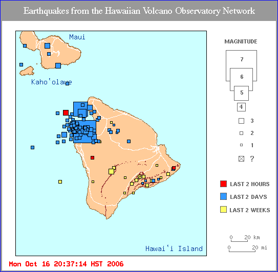
The Aftershock
of 23 November 2006 - A
strong (magnitude 5.0) aftershock occurred at 19:20:10 (UTC)
on November 23, 2006 along the Hulalai volcano's Northwest rift
zone. The epicenter of the aftershock was at sea (19.890°N,
155.979) in the same general area as the main quake of October
15, 2006°W. Its focal depth was also deep - 37.7 km (23.4
miles)
 Major aftershock
of the Hualalai earthquake on November 23, 2006 (U.S. Geological
Survey, Hawaii Volcano Observatory map)
Major aftershock
of the Hualalai earthquake on November 23, 2006 (U.S. Geological
Survey, Hawaii Volcano Observatory map)
Damages
Most of the damage
occurred on the west side of the island of Hawaii but there was
also damage on Maui and Oahu. There were no reported fatalities.
The earthquake disrupted air traffic on all major islands and
knocked out power on parts of the Big Island, Maui and all of
Oahu.
On the island of Hawaii,
there was major structural damage at Kona Hospital, the Royal
Kona Resort and the Honokaa Long-term Care Facility. There was
also some damage to the ceiling at Kohala Hospital. There were
reports of boulders crashed onto the highways. The state Department
of Transportation estimated the damage to state roads and bridges
at about $20 million. Total damage estimates are expected to
increase to over $200 million.
On the island of Oahu
there was major power outages that forced the disruption of flights
at the Honolulu International Airport. The City of Honolulu is the most populous and visited by tourists.
Several flights out of
Maui, and the island of Hawaii Island were disrupted or cancelled.
 Hawaii Volcano
Observatory Map of Intensities associated with the 15 October
2006 Earthquake
Tectonic
Setting - Geological Instability - Regional Seismic Activity
Hawaii Volcano
Observatory Map of Intensities associated with the 15 October
2006 Earthquake
Tectonic
Setting - Geological Instability - Regional Seismic Activity
The Hawaiian islands
are located in the middle of one of the largest tectonic plates
on Earth - the Pacific Plate. The islands were built by volcanoes
formed by a 'hot spot' which has been migrating in a southeast
direction for millions of years along a spreading center of the
Pacific tectonic plate. Most of the volcanoes that comprise the
Hawaiian islands have become extinct and eroded - some to sea
level. The island of Hawaii has been building up faster than
it has been eroding. The weight of the island has buckled the
earth's crust and isostatic adjustements often occur to establish
gravitational equilibrium.
The earthquakes of
October 15, 2006 were caused by isostatic response to crustal
loading on the island of Hawaii. The cluster of aftershocks below
the Hualalai volcano and their apparent clustering and distribution
along an almost east-west slip plane are in close proximity to
the Hualalai volcano's northwest rift zone that extends offshore
to the west but is truncated by the Mauna Loa volcano to the
east. A cluster of similar earthquake occurred below the Hualalai
volcano in September and October 1929.
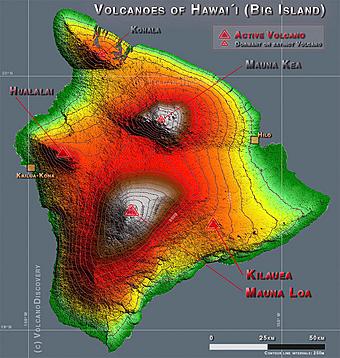 Hualalai Volcano Hualalai Volcano
Hualalai is one of
the five major shield volcanoes on the Island of Hawaii. Kohala,
Mauna Kea, Mauna Loa and Kilauea are the other four. Kohala's
last eruption was about 60,000 years ago and Mauna Kea 's last
eruption was about 3,500 years ago - thus these volcanoes are
considered to be dormant. Hualalai, Mauna Loa and Kilauea have
been active in the last 100 to 200 thousand years and may have
had simultaneous eruptions.
The five volcanoes
of the Island of Hawaii.
Mauna Loa erupted
in 1984. Kilauea is one of the most active volcanoes on Earth.
In the last forty years it has erupted more than 30 times. Hualalai's
last eruption was in 1801. Although this last eruption occurred
over 200 years ago, Hualalai is considered active.
The Summit
of the Hualalai Volcano (web photo)

The Hualalai volcano
has a well-developed Northwest rift zone, a moderately developed
South-Southeast rift zone, and a rather underdeveloped North
rift zone. The volcano completed its main Tholeiitic shield-building
stage about 120,000 years ago. The trachyte cone known as "Puu
Waawaa" , formed about 105,000 years ago on the north rift
zone and generated lava flows that traveled about 10 km (6 miles).
Post-shield volcanism began about 100,000 years ago and covered
the entire surface of the volcano. Hualalai is now in its post-shield
capping stage. Although inactive at the present time, it could
erupt again. Capping eruption events are usually more violent
but usually localized.
Hualalai's summit
has an elevation of 2,523 m (8,271 ft) above sea level. The most
recent eruptions occurred along the Northwest rift zone in 1800-1801.
Two major flows from these eruptions reached the sea. The 1800
"Kaupulehu" flow traveled in a northward direction
and destroyed a Hawaiian village in its path. The 1801 "Huehue"
flow traveled eastward and reached the sea, where the present
Kona's Keahole airport has been built. The 1800-1801 eruptions
of the Hualalai volcano may have been concurrent with an eruption
the Mauna Loa.

MAJOR HISTORICAL
EARTHQUAKES ON THE ISLAND OF HAWAII
Historical earthquakes
in the Hawaiian Islands have been well documented in two major
publications: the modern (1959-1997) catalog of the Hawaiian
Volcano Observatory, supplemented by the historic (1868-1959)
catalog.
November 16, 1983
- The most recent
event, prior to the October 15, 2006 earthquake occurred under
the east flank of Mauna Loa volcano. It had a similar magnitude
of M6.7.
November 29, 1975
- This earthquake
had a magnitude of M7.2 and occurred beneath Kilauea's South
Flank.
April 2, 1868 - This earthquake had an estimated
magnitude of M7.9 and occurred beneath the southeast flank of
Mauna Loa.
 Strong and
Major Historical Earthquakes on the Island of Hawaii (Note location
of the 5 October 1929 earthquake on the Hualalai volcano - much
closer to the summit and vents).
Strong and
Major Historical Earthquakes on the Island of Hawaii (Note location
of the 5 October 1929 earthquake on the Hualalai volcano - much
closer to the summit and vents).
Small Tsunami
Recorded
As shown below a tsunami
of small amplitude was recorded by the Pacific Tsunami Warning
Center's (PTWC) tide gauge at Kawaihae harbor on the island of
Hawaii. The travel time of the first wave to Kawaihae harbor
was at about 17:15 GMTor aproximately 7 minutes and 12 seconds
after the earthquake, which occurred at 17:07:48. The period
of the tsunami waves at the Kawaihae harbor gauge was about 12
minutes. Such long period is extremely unusual given the limited
dimensions of the earthquake source. The cause of this anomaly
is being investigated.
 The smal tsunami
as recorded by PTWC's Kawaihae Harbor tide gauge.
The smal tsunami
as recorded by PTWC's Kawaihae Harbor tide gauge.
Is the Earthquake
of October 15, 2006 a Prelude to a Future Eruption of the Hualalai
Volcano?
The Hualalai volcano
poses a real threat to the northwest region of the island of
Hawaii because of the extensive recent urban development. The
summit of the volcano is only a few km away from the city of
Kailua. Lava flows from a potential future eruption of Hualalai
represent the greater danger, rather than a pyroclastic eruption
at the summit. Although more than two hundred years have elapsed
since the last eruption, Hualalai will most definitely erupt
again.
The main earthquake
of October 15, 2006 and the distribution of aftershocks closely
align with the volcano's well-developed Northwest rift zone.
Whether this quake is a prelude to a future eruption is not yet
known, but it is possible and should be of concern. When such
eruption may occur is not known. It could occur in the near future
or years from now.
The 1929 swarms of
earthquakes - over a period of a month - did not result in any
major activity of the volcano. However these earthquakes may
have brought magma up and closer to the volcano's vents. The
geologic history of Hualalai indicates that the volcano erupted
about 200 times in the last 10,000 years. This would indicate
a recurrence interval of about 50 years for eruptions. However,
most of Hualalai's past eruptions have occurred in clusters,
often separated by several centuries of inactivity. Whether the
recent earthquake of October 15, 2006 will be followed by further
upward magma movement, remains to be seen. The Hawaii Volcano
Observatory is certainly keeping a close watchful eye on Hualalai's
behavior.
Can a Future
Earthquake near the Rift Zone of the Hualalai Volcano Generate
a Tsunami?
The earthquake of
October 15, 2006 had a focal depth of 29 Km which was rather
deep to generate a tsunami. Also the afteschock distribtution
indicates that most of the crustal movement occured on land along
and under the Northwest rift zone of the Hualali volcano. The
offshore crustal displacements were not large enough to generate
a tsunami of any significance. The magnitude of the earthquake
was 6.7 which is rather marginal for tsunami generation. However,
it should be emphasized that a shallow crustal earthquake of
6.7 magnitude (or greater), near the volcano's decollement region
(possibly at a depth of about 8- 10 km) - which may involve flank
failure - has the potential to generate a significant and potentially
dangerous tsunami that could affect, not only the island of Hawaii
but also the other Hawaiian islands.
 REFERENCES
AND ADDITIONAL DOCUMENTATION OF EARTHQUAKES AND TSUNAMIS IN THE
HAWAIIAN ISLANDS
REFERENCES
AND ADDITIONAL DOCUMENTATION OF EARTHQUAKES AND TSUNAMIS IN THE
HAWAIIAN ISLANDS
Klein F. W., Frankel A. D., Mueller
C. S.,. Wesson R. L. and P. G. Okubo, 2001. Seismic Hazard in Hawaii: High Rate of Large
Earthquakes and Probabilistic Ground-Motion Maps. Bulletin of the Seismological Society of America,
91, 3, pp. 479-498, June 2001
Klein F. W. and Wright T. L., 2000.
Catalog of Hawaiian
Earthquakes, 1823-1959,U.S. Geological
Survey Professional Paper 1623, U.S. Department of the Interior.
Pararas-Carayannis, G.,1976. The Earthquake and Tsunami of
29 November 1975 in the Hawaiian
Islands, ITIC Report, 1976. See also
http://drgeorgepc.com/Tsunami1975Hawaii.html
Pararas-Carayannis, G., and Calebaugh
P.J., 1977. Catalog
of Tsunamis in Hawaii, Revised and
Updated, World Data Center A for Solid Earth Geophysics, NOAA,
78 p., March 1977.
Pararas-Carayannis, G., 1986. Earthquakes - Basic Principles. International Tsunami Information
Center Report, Nov. 1986.
Pararas-Carayannis, G., 2002. Volcanically Generated Tsunamis, 2nd Symposium of the Tsunami
Society, Honolulu, Hawaii, May 25-29, 2002 See also
http://drgeorgepc.com/TsunamiVolcanicMechanisms.html
Pararas-Carayannis, G. 2002, "EVALUATION OF THE THREAT
OF MEGA TSUNAMI GENERATION FROM POSTULATED MASSIVE SLOPE FAILURES
OF ISLAND STRATOVOLCANOES ON LA PALMA, CANARY ISLANDS, AND ON
THE ISLAND OF HAWAII "Science
of Tsunami Hazards, Vol 20, No.5, pages 251-277, 2002. See also
http://drgeorgepc.com/TsunamiMegaEvaluation.html
Pararas-Carayannis, G., THE EARTHQUAKE AND TSUNAMI OF
29 NOVEMBER 1975 IN THE HAWAIIAN ISLANDS http://drgeorgepc.com/Tsunami1975Hawaii.html
Pararas-Carayannis G. 2004, TSUNAMIGENIC EFFICIENCY OF VOLCANICALLY,
SEISMICALLY AND GRAVITATIONALLY INDUCED ISLAND EDIFICE MASS FAILURES
AND OF AERIAL AND SUBMARINE LANDSLIDES.
32nd International Geological Congress, (T11.15 (115) Tsunami
hazard from slope instability), Florence, Italy, August 20-28,
2004
http://drgeorgepc.com/TsunamiEfficiency.html
Pararas-Carayannis G. 2005. INSTABILITY OF KILAUEA VOLCANO'S
SOUTHERN FLANK - EVALUATION OF MASS EDIFICE FAILURES, FLANK COLLAPSES
AND POTENTIAL TSUNAMI GENERATION
http://drgeorgepc.com/VolcanoHawaiiKilaueaInstab.html
Rundle J. B., 1988a. "A physical model for earthquakes:
1. fluctuations and interactions".
Journal of Geophysical Research, 93(B6):6237-6254, June 1988.
Rundle, D. Turcotte, L. and William
Klein, editors, 2000. GeoComplexity
and the Physics of Earthquakes, number
120 in Geophysical Monograph series, pages 211-218. AGU Books
Board, 2000.
Return to

  Links to other
Pages
Links to other
Pages

 Now available
from Amazon, Barnes and Noble and other major bookstores. A signed
by the author copy can be also ordered by contacting directly
by email Aston
Forbes Press.
Now available
from Amazon, Barnes and Noble and other major bookstores. A signed
by the author copy can be also ordered by contacting directly
by email Aston
Forbes Press.
 Other
Miscellaneous Non-technical Writings
Other
Miscellaneous Non-technical Writings
(©) Copyright
1963-2007 George Pararas-Carayannis / all rights reserved / Information
on this site is for viewing and personal information only - protected
by copyright. Any unauthorized use or reproduction of material
from this site without written permission is prohibited.
|