The
March 9, 1957 Aleutian Tsunami
George Pararas-Carayannis
(Excerpts
from the archives to the Catalog of Tsunami in the Hawaiian Islands.
World Data Center A- Tsunami U.S. Dept. of Commerce Environmental
Science Service Administration Coast and Geodetic Survey, May
1969)

Summary
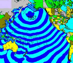
On March 9, 1957,
a great earthquake - the third largest earthquake the 20th century
- with a moment magnitude of 8.3 occurred south of the Andreanof
Islands in the Aleutian Islands of Alaska. It generated a destuctive Pacific-wide
tsunami.
 Earthquake Time, Origin and Epicenter
and Magnitude - The
earthquake occurred on March 9, 1957, at 14:22 GMT. Its epicenter
was at 51.5 North , 175.7 West., south of the Andreanof Islands.
The quake's focal depth was less than 33 km. Earthquake Time, Origin and Epicenter
and Magnitude - The
earthquake occurred on March 9, 1957, at 14:22 GMT. Its epicenter
was at 51.5 North , 175.7 West., south of the Andreanof Islands.
The quake's focal depth was less than 33 km.
Earthquake Aftershocks - A series of major aftershocks
followed the main earthquake. Their epicenters were spread over
a very large zone of about 1200 km.
 The
Tsunami of March 9, 1957
The
Tsunami of March 9, 1957
The earthquake
of March 9, 1957 generated
a Pacific-wide tsunami which caused considerable damage at coastal
areas in Alaska, British Columbia, Washington, Oregon and California.
It is estimated that the tsunami source area was about 850-900
km long.
Aleutian Islands - Near the generating area maximum
waves of up to 22.8 meters occurred at the Aleutian island of
Unimak, where sheep camps were washed away and docks and a concrete
mixer were destroyed. At Atka, another Aleutian island, tsunami
waves of up to 9.1 meters destroyed houses and washed away the
harbor facility and its oil supply storage tanks. At Chernofski,
waves drowned sheep at a sheep ranch. At the island of Adak,
waves of about 4 meters destroyed all the structures at the harbor
dock.
California - At Point Lobos (near Monterey),
in California the reported tsunami wave height was 0.6m and two
people were swept from rocks along the shoreline. At San Diego,
the height of the tsunami wave was 0.2m.
 The 1957 Tsunami in
the Hawaiian Islands The 1957 Tsunami in
the Hawaiian Islands
The
Hawaiian Islands suffered by far the greatest damage.
 Midway Island - There was unusual flooding Midway Island - There was unusual flooding
Tsunami flooding at
Midway Island.
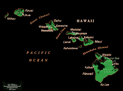
Kauai - Maximum runup and damage occured
at the northern part of the island of Kauai, near Haena point,
where the tsunami waves reached heights of 16 m, almost twice
the height of the 1946 tsunami. The waves destroyed bridges and
sections of Kauai's highways were flooded. Houses were washed
out and destroyed at Wainiha and Kalihiwai. A total of 75 homes
were destroyed or badly damaged on Kaua'i - twice the number
of those damaged by the 1946 tsunami.
 Oahu
- Maximum tsunami
wave heiht of 23 ft. was reported. Oahu
- Maximum tsunami
wave heiht of 23 ft. was reported.
Molokai - The tsunami waves with runup
heights of more than 14 ft in Kalaupapa smashing the water pipeline.
Maui - At Kahului harbor the tsunami
induced strong currents and extreme turbulence,
Hawaii - At Hilo, the maximum tsunami
run-up was 3.9 m. The tsunam flooded the wharf by about two feet
and damaged the warehouse and its contents . Numerous buildings
along the waterfront were damaged. Coconut Island was covered
by 1 m of water and the bridge connecting it to shore, as in
1952, was again destroyed. There was floding along the coastal
streets. Fortunately, the 1957 tsunami was nothing like the 1946
tsunami and no lives were lost.
Tide Gauge record
of the 1957 tsunami at Hilo, Hawaii
Elsewhere in the Hawaiian
Islands - The rest
of the Hawaiian islands islands received waves averaging 2 to
3 m.
Total damage in the
Hawaiian Islands was estimated at approximately $5 million (in
1957 dollars).
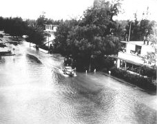
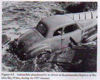
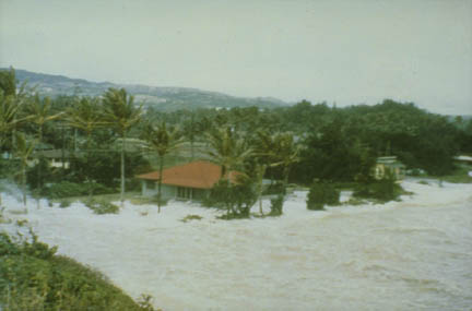 Photographs of tsunami inundating
Laie Point , and along Kamehameha Highway at Waiaha Bay on the
Island of Oahu (from ITIC and NGDC archives). Photographs of tsunami inundating
Laie Point , and along Kamehameha Highway at Waiaha Bay on the
Island of Oahu (from ITIC and NGDC archives).

References
Cox D.C. and G. Pararas-Carayannis
(1976). Catalog of tsunamis in Alaska revised 1976, World
Data Center A, NOAA, Boulder, CO, Report SE-1, 43 pp.
Dudley, W.C. and M.
Lee (1988). Tsunami!. Honolulu, Hawaii: University of
Hawaii Press.
Iida, K., D.C.
Cox, and G. Pararas-Carayannis (1967). Preliminary catalog of tsunamis occurring in
the Pacific Ocean, Hawaii Inst. of Geophys., HIG-67-10, University
of Hawaii, 131 pp.
Johnson, J.M. and
K. Satake (1993). Source parameters of the 1957 Aleutian earthquake
from tsunami waveforms, Geophys. Res. Lett., 20, 1487-1490.
Johnson, J.M.,
Y. Tanioka, L.J. Ruff, K. Satake, H. Kanamori, and L.R.Sykes
(1994). The 1957 great Aleutian earthquake, Pageoph, 142, 3-28.
Kanamori, H. (1977).
The energy release in great earthquakes, J. Geophys. Res.
82, 2981-2987.
Lander, J.F. (1996).
Tsunamis Affecting
Alaska 1737-1996, NGDC Key to Geophysical Record Documentation
No. 31, NOAA, NESDIS, NGDC, 195 pp.
Lander, J. F. and
P. A. Lockridge., (1989) United States Tsunamis. Publication
41-2. U.S. Department of Commerce. August .
Lander, J.F., P.A.
Lockridge, and M.J. Kozuch (1993). Tsunamis Affecting the
West Coast of the United States 1806-1992, NGDC Key to Geophysical
Record Documentation No. 29, NOAA, NESDIS, NGDC, 242 pp.
Salsman, G.G. (1959).
The tsunami of
March 9, 1957, as recroded at tide stations, C&GS Technical
Bulletin #6, U.S. Dept. of Commerce, C&GS, 18 pp.
RETURN TO

Links
to other Pages
 NEW BOOK - THE
BIG ONE- The Next Great California Earthquake
NEW BOOK - THE
BIG ONE- The Next Great California Earthquake
 now available from
Amazon, Barnes and Noble and other major bookstores. It can be
also ordered by contacting directly Aston
Forbes Press.
now available from
Amazon, Barnes and Noble and other major bookstores. It can be
also ordered by contacting directly Aston
Forbes Press.

OTHER MISCELLANEOUS NON-TECHNICAL WRITINGS


(©) Copyright
1963-2007 George Pararas-Carayannis / all rights reserved / Information
on this site is for viewing and personal information only - protected
by copyright. Any unauthorized use or reproduction of material
from this site without written permission is prohibited.
|