|

EARTHQUAKES
IN CALIFORNIA - THE BIG ONE
(The Next Great
California Earthquake)
George Pararas-Carayannis
Excerpts
from Introduction to the book
©
2000 George Pararas-Carayannis Library of Congess ISBN: 0-9709725-0-4
/ all rights reserved

Introduction
SOUTHERN CALIFORNIA
(Disaster Scenario )
A typical working day is about to begin in the South Central
section of California. It is 7:50 on a sunny January morning
200?. Traffic is already building up to its peak on Highway 101.
All north-south routes in the area are jammed. Interstates 5
from the San Joaquin Valley and 15 through the Cajon Pass are
loaded with commuters. The same is true for the freeways to the
urban areas of Ventura, Los Angeles, Torrance, Riverside, and
San Bernardino.
Yet, in exactly six minutes, this affluent, sophisticated, and
highly populated region will suffer a catastrophic change. It
is not the nature of this planet to be still. An endless continuity
of change and movement must be sustained. A process that began
many decades ago is nearing now its inevitable conclusion. A
250-mile segment of the San Andreas Fault, extending from Parkfield
in Central California southward to San Bernardino, has graduallybeen
forced into an unstable, strained position, held there by the
strength of its rocks. Here, in this zone of weakness, 20 kilometers
beneath the surface, this crustal block has reached the critical
limit of its strength. The supporting rocks will rupture and
the fractured blocks will slip across each other. This adjustment
along this boundary of active tectonic plates marks a point in
the movement towards a new equilibrium.

The pilot of a helicopter surveying the traffic checks his watch.
It is 7:55 a.m. He reports to a local radio station that nothing
unusual can be observed, no accidents, no stalled cars. Everything
is going smoothly. It looks like a quiet morning. He asks the
station to telephone his wife to tell her he'll be back by 10
o'clock to take her and the baby to the pediatrician.
At 7:56 a.m., a slight tremor is felt. Very gently at first.
But it grows increasingly strong until the ground shakes violently
for 20 to 25 seconds. In that infinitesimally minute fraction
of time, the area that has taken years to develop is devastated.
The pilot in the helicopter looks below in distress. He tries
to make radio contact again with his base. There is no response.
Only silence. For miles around, wherever he looks, there is a
horrific scene of carnage, chaos, and destruction. He stares
in disbelief at the overpasses lying strewn on what remains of
the highways. Demolished buildings form gigantic piles of rubble,
entombing their dead and screaming occupants. On the highway
below, an overturned tanker truck engulfs within its fiery cloak
other vehicles around it as well as their trapped motorists.
The shaking stops. A momentary respite only. After 10 seconds,
it resumes violently for another 30 to 40 seconds. Cars have
piled up in tangled masses of wreckage, others have veered off
the highways. Some are ablaze. Some have been buried by landslides.
Hundreds of dazed and injured survivors stumble about hysterical,
shocked, directionless.
It is now 7:59 a.m. In less than three minutes, thousands of
people have been killed and thousands more are injured. Many
more have been made homeless. Barely able to control his craft,
the pilot is disoriented. Nothing he has seen in Vietnam, on
television, or at the movies has prepared him for this. In terror
and panic, he tries to find his home. He has flown over it many
times before. The familiar landscape is almost unrecognizable.
He finds space to land amidst uprooted trees in the park near
his home. He runs toward the rubble that used to be his home.
He crawls and claws his way over the masonry. There is only one
thought in his mind, one prayer: please God, let them be alive,
please God....He yells the names of his wife and daughter. There
is no answer.

Mobilization
The violence of the shock is a warning to CivilDefense officials
on duty, in the stricken area, that a major and possibly catastrophic
earthquake has just occurred. At 8:01 am, the Office of Emergency
Services in Sacramento, receives an urgent message from the Los
Angeles County Civil Defense Warnings Center that a destructive
earthquake has struck Southern California and that a state of
emergency exists. The urgent message comes in on the California
Warning System (CALWAS), the state's emergency telephone system.
The announcement is heard simultaneously by all warning points
throughout the state. Based on the urgency of the announcement,
the Warning Controller on-duty at the headquarters of the Office
of Emergency Services (OES) activates the state's Emergency Operations
Center (EOC).
Following predetermined procedures, the staff of EOC alert the
other OES staff, the Governor's Office, the California National
Guard (CNG),the California Conservation Corps (CCC), the Emergency
Medical Services Authorities (EMSA), the California Highway Patrol
(CHP), and many other government and private organizations. The
emergency announcements continue to go out to all warning points
in the state via CALWAS, to all the warning points throughout
the country on the National Warning Network (NAWAS)-a communications
system operated by the Federal Emergency Management Agency (FEMA),
and on the North American Defense Communications System (NORAD).
One by one, County Civil Defense Centers in Orange, Riverside,
San Bernardino and Santa Barbara report to the Sacramento Office,
on the same emergency communications system, that a state of
emergency exists and the activation of their EOCs.
 Within a few minutes after the major shock ends,
these officials begin converging on their operating centers in
the affected counties. Fortunately, because of the time of the
day, some are already at work. Officials from other participating
federal and state agencies, trained to respond quickly to such
emergencies, attempt to reach their operating centers. The severity
of the earthquake is beginning to be realized. Within a few minutes after the major shock ends,
these officials begin converging on their operating centers in
the affected counties. Fortunately, because of the time of the
day, some are already at work. Officials from other participating
federal and state agencies, trained to respond quickly to such
emergencies, attempt to reach their operating centers. The severity
of the earthquake is beginning to be realized.
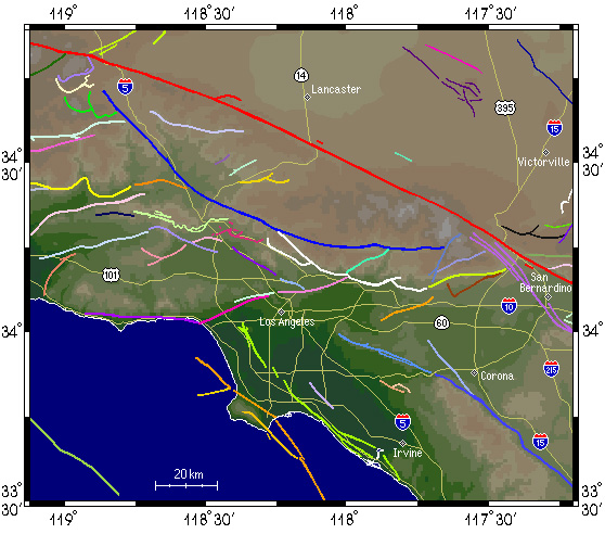
Faults in the vicinity
of Los Angeles
The California Institute of Technology provides the Sacramento
Office with the earthquake's magnitude and approximate epicenter.
The earthquake has magnitude of 8 plus and its epicenter is in
the mountains north of San Bernardino. Immediately, the Governor
is informed by telephone of the disaster. Cancelling all business
and functions the Governor phones the President at the White
House to inform him of the disaster, and asks him for federal
aid. The governor then makes arrangements to fly to the stricken
areas by helicopter, despite the continuing aftershocks, to help
direct the relief program.
EOC repeats the Cal Tech information on CALWAS, NAWAS, and NORAD.
At 8:10, EOC activates the state's Emergency Broadcast System
(EBS). EBS overrides functioning communications media, radio
and television, providing the public with preliminary information
on the earthquake, its epicenter, magnitude, and initial, unconfirmed
reports of the extent of the damage, as provided by local radio
operators. The state's EBS gives additional information and issues
instructions to survivors on how to maximize their safety and
minimize dangers of post-earthquake effects such as those caused
by aftershock fires, gas explosions, and tsunamis. Functioning
television and radio stations broadcast special announcements
and local newscasters relay information as it is reported.
The EOC in Sacramento initiates communications tests with all
civil defense centers in Los Angeles; Kern, Orange, Riverside,
San Bernardino, Santa Barbara, and Ventura Counties, in the region
that has been afflicted. Most are functioning, but some are only
on emergence radio communications and emergency power. Orange
County's EBS, which was down temporarily, resumes broadcast when
an emergency generator is reactivated. Most communication facilities
throughout these counties have failed. Radios are the only operable
communications medium. There are numerous and unconfirmed reports
from amateur radio operators that are relayed to the public by
local stations, but these reports are conflicting and create
additional confusion.
It is now 8:11. The National Earthquake Information Center (NEIC)
in Boulder, Colorado provides updated earthquake data from its
worldwide network. The magnitude of the earthquake is 8.3 and
the epicenter is in the vicinity of the Tehapachi Mountains.
The Pacific Tsunami Warning Center (PTWC), in Hawaii and the
Alaska Tsunami Warning Center (ATWC) via NAWAS confirm the magnitude
and epicenter of the earthquake.
Brief and incomplete reports from the police, fire departments,
and CB operators provide preliminary assessments of the damage
and assistance needed. County radio transmissions are monitored
and received at Regions I and VI of the OES. One by one the counties
report on the disaster.
Disaster Reports
 Kern County: A great deal of destruction and numerous deaths
and injuries are reported from all areas in the southeast section
of Kern County. The telephone service, electricity, gas, and
water have been disrupted in Bakersfield. Massive rockslides
are reported along Interstate 5 at Grapevine. Highway 99 and
I-5 have been heavily damaged from Corpus Road to the south.
Poisonous chemical spills are reported from Wheeler Ridge area.
Finally, from the southeast section of Kern County, severe damage
and a high number of casualties have been reported. Efforts to
make contact with the east of the county and with the mountain
communities of the Woods and Pine Valleys have failed. Kern County: A great deal of destruction and numerous deaths
and injuries are reported from all areas in the southeast section
of Kern County. The telephone service, electricity, gas, and
water have been disrupted in Bakersfield. Massive rockslides
are reported along Interstate 5 at Grapevine. Highway 99 and
I-5 have been heavily damaged from Corpus Road to the south.
Poisonous chemical spills are reported from Wheeler Ridge area.
Finally, from the southeast section of Kern County, severe damage
and a high number of casualties have been reported. Efforts to
make contact with the east of the county and with the mountain
communities of the Woods and Pine Valleys have failed.
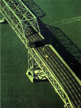
Damage to
Bay Bridge from the Earthquake of 1989
Los Angeles County: The Los Angeles County's EOC
on Eastern Avenue, utilizing helicopters from the sheriffs department
and the L.A. County Fire Department, has begun an aerial reconnaissance
of critical facilities and areas. The hardest hit areas are those
in the north, particularly Lancaster, Palmdale, Quartz Hills,
and Gorman. These have been totally devastated. High casualties
are reported. The Los Angeles /Long Beach areas have been seriously
damaged. Similarly, central Los Angeles has been seriously impacted
and all the freeways are blocked with heavy traffic or abandoned
vehicles. At Los Angeles International Airport, critical damage
to the control tower and to all the major runways have brought
all operations to a halt. All airports are reported to be closed
for evaluation of runways and structures supporting the air traffic
operations. Thousands of people are left stranded. Fires are
reported from the general area of the harbor where the refineries
are located. Hospitals in the Newhall area have been damaged
and medical facilities are inadequate to treat the vast numbers
of injured. The Los Angeles Aqueduct has been severely damaged
and a great deal of water can be seen escaping. Traffic is worse
on Interstate 405, and the I-55 last Main Street overpass has
collapsed with several cars buried underneath.
Orange County: In Orange County, a landslide
at Green River has Highway 91 blocked in Santa Anna Canyon. The
bridge to Balboa Island has been destroyed. Traffic has been
completely stopped on Interstate 405. There are reports of injuries
and property damage in the Santa Anna area. Many have been trapped
and are injured in the County Administration Building. The death
toll in the county is high and increasing. Medical facilities
at Irvine Medical Center are reported as being extensively damaged
and barely functioning. The San Onofre Nuclear Generating Plant
has declared an emergency as its cooling system has been partially
destroyed. Personnel are working frantically to shut the plant
down and to activate the secondary cooling system to reduce reactor
core temperatures that continue to rise. Chemical spills at Westminster
are also causing concern.
Riverside County: In Riverside County, the EOC
reports failure of all communications. Sketchy reports indicate
that parts of Riverside and Corona and other communities along
the Santa Ana River have been razed to the ground. However, Palm
Springs and Hemet have escaped with only light structural damage.
In the worst affected areas, the casualty list is high and growing.
Initial reports indicate that over 300 people have died, with
thousands more injured. In some areas, looting is taking place.
Fires are burning uncontrolled in many parts near the industrial
areas. The bridge over the river on Highway 61 has collapsed.
The overpass of Highways 60 and 91 have collapsed as well.
San Bernardino County: In San Bernardino County, heavy
damage has occurred at the Atchison, Topeka, Santa Fe, Union
Pacific, and Southern Pacific railroads due to numerous overpass
and bridge failures. A freight train has been derailed between
Cajon Pass and Whitewater. Norton Air Force Base and Ontario
Airport are nonoperational. High voltage lines have fallen on
Highway 191 at Colton. Traffic has been halted at all the intersections
of I-5 with I-15 and the I-10 interchange northwest of San Bernardino
City. Extensive damage is reported throughout the county except
in the mountain communities of Big Bear and Arrowhead where damage
is moderate. Several thousand homes have been damaged or destroyed
with unknown damage to business and industrial complexes. The
death toll is mounting with serious injuries of a thousand or
more. St. Bernadine's, Cino General, Doctors Hospital-Monclair,
Redlands Community Hospital, and the County Medical Center have
all been damaged and are unable to cope with the vast numbers
of injured.
Santa Barbara: From Santa Barbara, there are
reports of massive landslides at Gaviota Pass on Highway 101
at the San Marcos Pass, isolating the north county area from
the south. All attempts to make contact with Quyama Valley have
failed. The dam at Twitchell Reservoir has suffered structural
damage and water is leaking from it. Telephone, electricity,
and water services have been totally disrupted. No specific reports
of deaths or injuries have been received.
Ventura County: Ventura County has been devastated,
and a high casualty rate is indicated. All telephone, communications,
electricity, gas, and water lines have been disrupted. Liquefaction
of the ground has caused extensive destruction at Ventura, Oxnard,
Thousand Oaks, San Pedro, Long Beach, Huntington Beach, and along
the entire length of the Santa Ana River. Isolated pockets of
liquefaction have also occurred at Inglewood, Pacific Palisades,
Beverly Hills, and San Fernando. Bridges have collapsed along
the Santa Clara River at Highways 101, 118, and 33. Massive landslides
have closed Routes 123,33 north of Ojai, and 150. Industrial
fires are burning at Ventura and Newbury Parks. Many schoolchildren
have already been trapped at one school in Ventura and many others
are trapped in school buses. Some children are reported as roaming
aimlessly in the streets. Hundreds of fatalities and injuries
are reported. Urgent radio transmissions indicate the need for
helicopter transport of casualties.

Only a Partial Scenario
of the Disaster
This is only a partial
scenario of what could happen if an earthquake of magnitude 8
or greater on the Richter scale struck southern California during
the morning rush hour with its epicenter in the mountains northeast
of Los Angeles. The scenario is based partially on an earthquake
readiness exercise conducted by the State's Emergency Services
Office in 1981 and on a reconstruction of the 1857 Fort Tejon
earthquake.
What Could
Really Happen
If a large earthquake
strikes during rush hour southern California around the Los Angeles
metropolitan area, similar to the 1857 earthquake, it would kill
at least 3,000 to 15,000 people and hospitalize 12,000 to 50,000.
Landslides would block highways and all lifeline support systems
will be heavily damaged. Multiple other earthquake related disasters
would increase the death toll and the destruction.
If a similar earthquake occurred now in the Bay area during the
peak of the rush hour, as many as 11,000 to 12,000 people could
die and at least 45,000 to 50,000 might be hospitalized. Officials
in California have been forewarned by scientists about the strong
probability of a large earthquake occurring before the end of
the millennium. Scenarios of destruction and emergency plans
of action are in preparation in anticipation of such a catastrophe.
Effects of Earthquake
Disasters Can Be Minimized with Proper Planning and Preparation
Most Californian residents
live with the knowledge that earthquakes, at least minor ones,
are a part of their lives. Their homes and places of work are
mostly of unknown earthquake resistance. As yet, insufficient
thought has been given to the imminent prospect of an earthquake
of devastating proportions. The responses of many are unrealistic
or fatalistic. The former do not believe a serious earthquake
will happen in their lifetime, while the latter feel that even
if it does, nothing can be done about it.
Neither avoidance nor resignation will lower the casualty list
or save lives. Awareness and preparedness will. Among the many
misconceptions on the subject, one of the commonest is that only
the most destructive earthquakes kill directly. In fact, most
deaths are caused by structures falling and collapsing, such
as buildings, dams, and bridges. Gas lines rupturing cause fires.
Other hazards may include landslides, or local tsunamis that
would only affect the coastal areas.
Earthquake-related fatalities, injuries, and property destruction
can be avoided or minimized by correct planning, construction,
engineering, and land utilization. Education programs that teach
earthquake awareness and safety measures should be taught throughout
the state in schools, colleges, at home, and at the place of
work.
Structures can be built that are earthquake resistant. Many buildings
and homes can be reinforced at a small cost to the individual,
company, or state to withstand the effects of an earthquake.
Lowering water level in potentially vulnerable dams would also
help to limit the destruction. Nuclear power plants and other
hazardous enterprises should not be permitted to function in
areas that are earthquake-prone. Regardless of the expense, Californians
should view any earthquake preparedness and planning as their
most valuable asset and investment. Preparations made in the
next few years will largely decide whether Californians die in
or survive the Big One.
About Accounting-Calculating the Costs of Natural Disasters:
Masters Degree in Accounting Online
Accounting Graduate Student Requirements
Doctorate in Accounting Schools
Skills in Accounting Alternatives
THE BIG ONE - The Next Great California
Earthquake -TABLE OF CONTENTS
BUY THIS BOOK
 now available from
Amazon, Barnes and Noble and other major bookstores. It can be
also ordered by contacting directly Aston
Forbes Press.
now available from
Amazon, Barnes and Noble and other major bookstores. It can be
also ordered by contacting directly Aston
Forbes Press.
 Return to

  Links to other
Pages
Links to other
Pages
Now available
from Amazon, Barnes and Noble and other major bookstores. A signed
by the author copy can be also ordered by contacting directly
by email Aston
Forbes Press.
 Other
Miscellaneous Non-technical Writings
Other
Miscellaneous Non-technical Writings
(©) Copyright
1963-2007 George Pararas-Carayannis / all rights reserved / Information
on this site is for viewing and personal information only - protected
by copyright. Any unauthorized use or reproduction of material
from this site without written permission is prohibited.
|