The Effects
of the March 28, 1964 Alaska Tsunami in British Columbia, Canada
George
Pararas-Carayannis

Tsunami Education |Educational Degrees | Online MBA | MBA Education | MBA Courses | College Courses
------------------------------------------------------------------------------
  Introduction Introduction
The Great Alaskan
Earthquake of March 28, 1964 generated a tsunami which was also
destructive in British Columbia, Canada, and in the U.S. States
of Washington, California and Hawaii. The tsunami waves were
particularly destructive at Vancouver Island. Serious damage
occurred at Alberni and Port Alberni.
 Tsunami Run up Heights and Tide Gauge
Measurements Tsunami Run up Heights and Tide Gauge
Measurements
As recorded at tide
gauges, the tsunami height was 1.4 meters at Prince Rupert and
1.2 meters at Tofino. Actual tsunami runup was higher.
Tsunami Travel Times
The tsunami generating
area of the 1964 earthquake was very extensive.
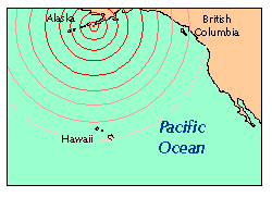 The
first wave to arrive at shores and tide stations in British Columbia
had its origin at the deeper part of the source region in the
Gulf of Alaska, near Kodiak and Trinity Islands. The
first wave to arrive at shores and tide stations in British Columbia
had its origin at the deeper part of the source region in the
Gulf of Alaska, near Kodiak and Trinity Islands.
 The
tsunami travel times were : Prince Rupert 3.3 hours; Tofino 3.8
hrs. The first wave was not necessarily the highest. Subsequent,
more significant waves - from the shallower part of the tsunami
source generating area - reached the West Coast of Canada and
Vancouver Island at a later time. The
tsunami travel times were : Prince Rupert 3.3 hours; Tofino 3.8
hrs. The first wave was not necessarily the highest. Subsequent,
more significant waves - from the shallower part of the tsunami
source generating area - reached the West Coast of Canada and
Vancouver Island at a later time.
 The tsunami travel time to Port
Alberni was 4.1 hrs. The tsunami travel time to Port
Alberni was 4.1 hrs.
The twin cities of
Alberni and Port Alberni are situated at the head of a 35 mile
long inlet on the west coast of Vancouver Island. This accounts
for the longer tsunami travel time. However, the tsunami travel
time to Alberni and Port Alberni, as reported by the newspapers
and the Civil Defense, appears to be longer. There was a two
hour difference. This is because first wave arrival was reported
in local, daylight savings time, and not in GMT. The
time discrepancy is evident from the seismogram of the 1964 Alaska
earthquake by the the Dominion Astrophysical Observatory in Victoria,
which recorded the quake at 7:36, Victoria time, a difference
of two hours - which serves to explain the discrepancies in reporting.
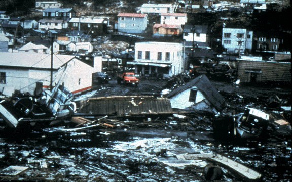
Tsunami
Damage at Port Alberni
 Tsunami
Periods Tsunami
Periods
The shallowness of
the continental shelf in the Gulf of Alaska contributed to the
long period of the waves, the dipole movement of the crustal
displacements, and many other factors of a complex source mechanism,
the significant waves may have indeed reached Port Alberni as
late as 5.5 hours after the earthquake. Tsunami periods as measured
from tide gauge records were as follows: Prince Rupert 92 minutes;
Tofino 20 minutes.

Tsunami
Effects
 The shape and configuration of the inlet were
the reason for the extensive flooding that occurred at Alberni
and Port Alberni. The first wave to reach the head of the inlet
caused major flooding but was not particularly damaging. It served
as a warning for people to evacuate. It was the second wave -
almost an hour later - that came with much greater force and
caused the greater damage by carrying homes and cars inland.
A total of 375 dwellings were damaged, with 55 being totally
lost. The shape and configuration of the inlet were
the reason for the extensive flooding that occurred at Alberni
and Port Alberni. The first wave to reach the head of the inlet
caused major flooding but was not particularly damaging. It served
as a warning for people to evacuate. It was the second wave -
almost an hour later - that came with much greater force and
caused the greater damage by carrying homes and cars inland.
A total of 375 dwellings were damaged, with 55 being totally
lost.
 Other areas of Vancouver island
sustained damage. At the village of Hot Springs Cove, 16 of its
18 homes were destroyed. At the community of Zeballos, 30 dwellings
were moved off their foundations and their contents were damaged.
At the small logging community of Amai, 10 homes were damaged. Other areas of Vancouver island
sustained damage. At the village of Hot Springs Cove, 16 of its
18 homes were destroyed. At the community of Zeballos, 30 dwellings
were moved off their foundations and their contents were damaged.
At the small logging community of Amai, 10 homes were damaged.
Loss of Lives and Damages
There was
no loss of lives on Vancouver Island or anywhere else in Canada.
Damage was estimated at $ 10 million (1964 dollars).


Photos of tsunami effects
at Port Alberni - courtesy of British Columbia Provincial Emergency
Program.
REFERENCES
BRITISH COLUMBIA CIVIL
DEFENCE, 1964. Special
Report on Alberni Tidal Wave Disaster, Provencial emergency Program. 38pp.
BROWN, D.L., 1964. Tsunami
Activity Accompanying the Alaskan Earthquake of 27 March 1964, U.S. Army Engr. Dist., Alaska,
ms., 20 pp.
IIDA, K., D.C. Cox,
and Pararas--Carayannis, George, 1967.
Preliminary Catalog
of Tsunamis Occurring in the Pacific Ocean. Data Report No. 5. Honolulu: Hawaii Inst.Geophys.Aug.
1967.
IIDA, K., D.C. Cox,
and G. Pararas-Carayannis, 1967b.
Bibliography to the
Preliminary Catalog of Tsunamis Occurring in the Pacific Ocean, Hawaii Inst. Geophys. Data Rpt.
6, HIG-67-25, Univ. of Hawaii, 27 pp.
SPAETH, M.G. and S.C.
Berkman, 1965, 1967. The Tsunami of March 38, 1964
as Recorded at Tide Stations,
U.S. Coast and Geod. Survey, 59 pp. (1965). Ibid. ESSA Coast
and Geod. Survey Tech. Bull. 33, 85 pp. (1967)
WHITE, W.R.H., 1966. The
Alaska Earthquake...its Effects in Canada, Canadian Geogr. Journ., v. 72, no. 6, pp. 210-219.

See also:
Additional photos of Tsunami Damage at Alberni
and Port Alberni
The
March 27, 1964, Great Alaska Earthquake
Source
Mechanism of the March 27, 1964, Great Alaska Earthquake and
Tsunami
The
March 27, 1964 Tsunami in the Gulf of Alaska
The
March 27, 1964 Tsunami Waves in Prince William Sound, Alaska
The
Effects of the March 27, 1964 Alaska Tsunami in the Hawaiian
Islands
Return to
 Links
to other Pages
Links
to other Pages
 NEW BOOK - THE
BIG ONE- The Next Great California Earthquake
NEW BOOK - THE
BIG ONE- The Next Great California Earthquake

 now available from
Amazon, Barnes and Noble and other major bookstores. It can be
also ordered by
contacting directly
Aston
Forbes Press.
OTHER MISCELLANEOUS NON-TECHNICAL WRITINGS
now available from
Amazon, Barnes and Noble and other major bookstores. It can be
also ordered by
contacting directly
Aston
Forbes Press.
OTHER MISCELLANEOUS NON-TECHNICAL WRITINGS


(©) Copyright
1963-2005 George Pararas-Carayannis / all rights reserved / Information
on this site is for viewing and personal information only - protected
by copyright. Any unauthorized use or reproduction of material
from this site without written permission is prohibited.
|

