|
The March 28,
1964 Tsunami Waves in Prince William Sound, Alaska
George
Pararas-Carayannis

Introduction
On March 28, 1964, at 03:28 GMT, the
largest earthquake of the 20th Century (surface-wave magnitude
8.4) in the northern hemisphere, occurred in the Prince William
Sound area of Alaska. The epicenter was at 61.1° N, 147.5°
W, and the quake's focal depth was 23 km.
Area Affected
by the Earthquake
The quake affected an area almost
1600 km long and more than 300 km wide - extending from Valdez
to the Trinity Islands, southwest of Kodiak Island in the Gulf
of Alaska. Many areas were uplifted by as much as 15 m (50 feet),
while other areas subsided significantly. Overall, the vertical
crustal displacements averaged 1.8 m (6 ft.) over an area of
about 300,000 square kilometers (115,000 square miles), and extended
far into the Gulf of Alaska's continental shelf. In addition
to triggering a destructive Pacific-wide tsunami, the quake and
subsequent landslides generated many local destructive tsunamis
within Prince William Sound.

Death Toll
and Damages
The combination of the earthquake
and tsunami waves practically destroyed five of Alaska's seven
largest communities. A total of 106 people lost their lives.
Damage was estimated at $84 million (1964 dollars). Alaska's
fishing industry and most of its seaport facilities were either
completely destroyed or severely crippled.
Earthquake
damage in Anchorage.
 Overall, the earthquake, the local tsunamis in
Prince William Sound, and the tsunami generated in the Gulf of
Alaska, were responsible for taking the lives of 122 people and
causing more than $106 million in damage (1964 dollars) - making
this disaster the costliest ever to strike Alaska, the Western
United States, and Canada. Overall, the earthquake, the local tsunamis in
Prince William Sound, and the tsunami generated in the Gulf of
Alaska, were responsible for taking the lives of 122 people and
causing more than $106 million in damage (1964 dollars) - making
this disaster the costliest ever to strike Alaska, the Western
United States, and Canada.
Tsunami
destruction of the railroad yard and seaport facilities at Seward.
Local Destructive
Tsunamis in Prince William Sound
Within the Prince William
Sound area, the Great Alaska earthquake of March 28, 1964 generated
separate tsunami waves by causing crustal uplift or subsidence
and triggering numerous large landslides above and below the
sea surface, as well as mud flows and slumping of alluvial deposits,
in bays and fjords. There was no time for warning. Within minutes,
huge tsunami waves generated by the earthquake and the landslides
destroyed local towns and fishing villages, killing 82 people.
The maximum wave height recorded within the Prince William Sound
was 67 meters at Valdez Inlet.
The shallow continental
shelf and the islands bordering the southern side of Prince William
Sound, as well as the pattern of crustal displacements, confined
the tsunami waves generated in this area, to the Sound itself
- very little energy escaped this closed region. Most of the
tsunami energy was expended in the narrow, deep fjords of the
Sound, creating catastrophic waves and setting up resonating
oscillations and surges that lasted for hours. In certain places
maximum inundation occurred five or six hours later, at high
tide.
 Two Major Tsunamis
Were Observed in Prince William Sound Two Major Tsunamis
Were Observed in Prince William Sound
Two major tsunamis were
distinguished in Prince William Sound : one had its origin near
the west coast of Montague Island, in the southern end of the
Sound; the other originated in the Port of Valdez region.
 Tsunami at the Southern End of the Sound (Chenega
Village, Perry and Naked Islands) Tsunami at the Southern End of the Sound (Chenega
Village, Perry and Naked Islands)
Maximum positive crustal
displacement (uplift) in Prince William Sound occurred along
the northwest coast of Montague Island and in the area offshore.
These earth movements caused a gradient in hydrostatic level
and numerous large submarine slides in the area off Montague
Island and at the north end of Latouche Island. Bathymetric surveys
by the USC&GS (1964) support that the combination of submarine
slides and the tilting of the ocean floor due to uplift, created
the solitary wave observed at these locations. It is believed
that this wave raced through Knight Island Passage within 10
minutes and on toward Chenega Island, inundating the village
of Chenega to an elevation of 27.5 m and completely destroying
it. This same solitary wave continued north through Knight Island
Passage and inundated Perry and Naked Islands, but to lesser
heights.
Tsunami at the Northern End of the Sound (Near
Valdez). A second distinct tsunami was generated at the northern
end of Prince William Sound near the Port of Valdez.
The proposition that
a second tsunami generation mechanism contributed to destructive
waves in the Northern end of Prince William Sound, is supported
by what was observed in the Valdez area. For example, at Valdez,
maximum inundation occurred five or six hours after the earthquake,
at high tide. The third wave came in at 2300, March 27, and the
fourth one at 0145, March 28 (Brown, 1964). This last wave took
the form of a tidal bore and inundated the downtown section of
Valdez, ruining almost all the merchandise in the stores. These
waves could not have come from the generating area outside Prince
William Sound because, if this were so, it would have taken them
only 34 minutes to reach Valdez . It is more likely, then, that
resonance effects in the Bay of Valdez were set up by the earthquake
which, at high tide, culminated in the destructive tsunami waves
in the immediate area of Port Valdez.
Effects of
theTsunami Waves in Prince William Sound
 Whittier: At Whittier, the waves reached a height of 31.7
m above low tide and were particularly destructive, killing thirteen
(13) of the 70 inhabitants and causing great damage to the small
boat harbor. The waves destroyed the railroad ramp handling towers
at the army pier, the Alaska Railroad depot, the Union Oil Company
tanks, the wharf and buildings, two saw mills and numerous frame
dwellings. Property damage at Whittier was estimated at $10 million
(1964 dollars). Whittier: At Whittier, the waves reached a height of 31.7
m above low tide and were particularly destructive, killing thirteen
(13) of the 70 inhabitants and causing great damage to the small
boat harbor. The waves destroyed the railroad ramp handling towers
at the army pier, the Alaska Railroad depot, the Union Oil Company
tanks, the wharf and buildings, two saw mills and numerous frame
dwellings. Property damage at Whittier was estimated at $10 million
(1964 dollars).
(Photo: Surging
tsunami wave left a 2 x 12 in. (5.2 x 31 cm) plank in a truck
tire at Whittier, Photo Credit: U.S. Geological Survey)
 Photo: Seward from
the air showing tsunami damage to oil
storage
tanks which caught fire and burned. Photo: Seward from
the air showing tsunami damage to oil
storage
tanks which caught fire and burned.
Seward:
At Seward, a community of about 2,300 people about 75 km from
the epicenter, a section of the waterfront slid into Resurrection
Bay. An overturned ship, destroyed a Texaco chemical truck. It
spread flaming petroleum over the waterfront, igniting the rolling
stock, the electrical generation plant, and some residences.
 Waves spread in all directions
destroying the Alaska railroad docks, washing out railroad and
highway bridges, and piling railroad rolling stock into giant
rows of wreckage. Eleven (11) deaths occurred in the Seward area.
Both the railroad yard and seaport facilities at Seward, Alaska,
received the heaviest damage. Resurrection Bay received about
$14.6 million (1964 dollars) in damage. Waves spread in all directions
destroying the Alaska railroad docks, washing out railroad and
highway bridges, and piling railroad rolling stock into giant
rows of wreckage. Eleven (11) deaths occurred in the Seward area.
Both the railroad yard and seaport facilities at Seward, Alaska,
received the heaviest damage. Resurrection Bay received about
$14.6 million (1964 dollars) in damage.

Photo: Destruction
at Resurrection Bay, Seward.
The tsunami
carried a large boat into the duck crushing it and
tearing apart. The boat oveturned and destroyed a Texaco chemical truck.
Valdez:
The town of Valdez is situated on the edge of a delta characterized
by unstable, water-saturated alluvial, sedimentary material,
such as gravels and sands. The earthquake's shaking immediately
caused failure and liquefaction of the material along Valdez'
waterfront. A giant portion of the unconsolidated sediments,
with dimensions approximately 1,220 meters long and 183 meters
wide, slid into the sea. The landslide carried the dock area
of Port of Valdez and a large portion of the waterfront. Within
two to three minutes after the landslide, a destructive local
tsunami wave, 9- 12 meters high, slammed into the remaining waterfront.
The wave demolished what was left of the waterfront facilities,
causing the loss of Valdez' fishing fleet, and inundating about
two blocks ot the town. Additionally, the
waves caused the tanks at the Union Oil Company to rupture, starting
a fire that spread across the entire waterfront, and thus destroying
the few structures that were still standing. Thirty (30) people lost their lives in Valdez.
Property damage was estimated at $15 million (1964 dollars).

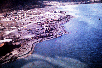
(Photo : Aerial
view of Valdez, Alaska, showing extent of inundation along thd
coastline. U.S. Department of the Interior photo - ITIC Arhives)
At the Valdez Inlet.
this large Valdez waterfront landslide or possibly in combination
with other landslides, generated a destructive tsunami that had
a maximum run-up of 67.0 m at the inlet.
Also, a second wave
of about 40 meters in height (125 feet) was reported coming out
of the Valdez Narrows and spreading across the Sound (Plafker and Mayo,
1965). It is believed
that this observed second wave was caused by the slumping of
the glacial deltas in Port Valdez - shaken loose by the force
of the earthquake.
Five or six hours after
the earthquake, at high tide, unusually high waves occurred again
at Valdez. A third wave came in at 2300, March 27 (local date
and time), and the fourth one at 0145, March 28 (Brown, 1964). This last wave took the form
of a tidal bore and inundated the downtown section of Valdez,
ruining almost all the merchandise in the stores. Maximum runup
at Valdez was 9.1 m. Apparently, these waves were
the result of resonance building up within the Bay of Valdez.
REFERENCES - Prince
William Tsunami Waves
BERG, E., D.C. Cox,
A. Furumoto, K. Kajiura, H. Kawasumi, and E. Shima, Field
Survey of the Tsunami of 28 March 1964 in Alaska, Hawaii Inst. Geophys. Rpt.
BROWN, D.L., 1964. Tsunami
Activity Accompanying the Alaskan Earthquake of 27 March 1964, U.S. Army Engr. Dist., Alaska,
ms., 20 pp.
COULTER, H. W. and
R. R. Migliaccio, 1966. Effects of the March 27, 1964
Earthquake at Valdez, Alaska,
U.S. Geol. Survey Prof. Paper 542-C, 36 pp.
COX, D.C. and Pararas-Carayannis,
George. A Catalog of Tsunamis in Alaska. World Data Center A- Tsunami
Report, No. 2, 1969.
IIDA, K., D.C. Cox,
and Pararas--Carayannis, George, 1967.
Preliminary Catalog
of Tsunamis Occurring in the Pacific Ocean. Data Report No. 5. Honolulu: Hawaii Inst.Geophys.Aug.
1967.
KACHADOORIAN, R.,
1965. Effects of the Earthquake of March 27, 1964 at
Whittler, Alaska,
U.S. Geol Survey Prof. Paper 542-B, 21 pp.
LEMKE, R.W., 1966. Effects
of the Earthquake of March 27, 1964 at Seward, Alaska, U.S. Geol. Survey Prof. Paper
542-E, 43 pp.
PARARAS-CARAYANNIS,
G., 1965. Source Mechanism Study of the Alaska Earthquake
and Tsunami of 27 March 1964: Part I. Water Waves, Univ. of Hawaii, Hawaii Inst.
Geophys. Tech. Rpt., HIG 65-17, pp. 1-28
PARARAS-CARAYANNIS,
G., 1967. A Study of the Source Mechanism of the Alaska
Earthquake and Tsunami of March 27, 1964, Water Waves. in Contributions of the H.I.G.
University of Hawaii for the Year 1967. Honolulu: s.n., 1967,
pp. 237.cont. No. IR4
PARARAS-CARAYANNIS,
G., 1967. Source Mechanism Study of the Alaska Earthquake
and Tsunami of 27 March 1964, The Water Waves. Pacific Science. Vol. XXI, No. 3, July 1967.
PARARAS-CARAYANNIS,
G. 1972. "Source
Mechanism of the Water Waves Produced." Pacific Science, Vol. 21, No. 3, "A Study of the Source Mechanism
of the Alaska Earthquake and Tsunami of March 27, 1964." Volume on Seismology and
Geodesy on the Great Alaska Earthquake of 1964, National Academy
of Sciences, Washington D.C., pp 249-258, 1972.
PLAEKER, G. and R.
Kachadoorian, 1966. Geologic Effects of the March
1964 Earthquake and Associated Seismic Sea Wave on Kodiak and
Nearby Islands, Alaska,
U.S. Geol. Survey Prof. Paper 543-D, 46 pp.
PLAFKER, G. and L.R.
Mayo, 1965. Tectonic Deformation, Subaqueous Slides and Destructive
Waves Associated with Alaskan March 27, 1964 Earthquake: An Interim Geologic Evaluation,
U.S. Geol. Survey, Menlo Park, Calif., 21 pp
VAN DORN, W.G., 1964. Source
Motion of the Tsunami of March 28, 1964 in Alaska, Proc. 9th Council on Coastal
Engr., Trans. Am. Soc. Divil Engr..
WOOD, F., ed., 1966. The
Prince William Sound, Alaska, Earthquake of 1964 and Aftershocks, v. 1, Operational Phases, U.S.
Coast and Geodetic Survey, No. 10-3, 263 pp.

See also:
The
March 27, 1964, Great Alaska Earthquake
Source
Mechanism of the March 27, 1964, Great Alaska Earthquake and
Tsunami
The
March 27, 1964 Tsunami in the Gulf of Alaska
The
March 27, 1964 Tsunami Waves in Prince William Sound, Alaska
The
Effects of the March 27, 1964 Alaska Tsunami in Canada
The
Effects of the March 27, 1964 Alaska Tsunami in the Hawaiian
Islands
Return to
 Links
to other Pages
Links
to other Pages
 NEW BOOK - THE
BIG ONE- The Next Great California Earthquake
NEW BOOK - THE
BIG ONE- The Next Great California Earthquake

 now available from
Amazon, Barnes and Noble and other major bookstores. It can be
also ordered by
contacting directly
Aston
Forbes Press.
OTHER MISCELLANEOUS NON-TECHNICAL WRITINGS
now available from
Amazon, Barnes and Noble and other major bookstores. It can be
also ordered by
contacting directly
Aston
Forbes Press.
OTHER MISCELLANEOUS NON-TECHNICAL WRITINGS

 (©) Copyright
1963-2004 George Pararas-Carayannis / all rights reserved / Information
on this site is for viewing and personal information only - protected
by copyright. Any unauthorized use or reproduction of material
from this site without written permission is prohibited.
(©) Copyright
1963-2004 George Pararas-Carayannis / all rights reserved / Information
on this site is for viewing and personal information only - protected
by copyright. Any unauthorized use or reproduction of material
from this site without written permission is prohibited.
|

