|
THE EARTHQUAKE
AND TSUNAMI OF 29 NOVEMBER 1975 IN THE HAWAIIAN ISLANDS
George
Pararas-Carayannis
(Excerpts
from a post-Tsunami Survey conducted on 30 November - 3 December,
1975, and from subsequent reports)

 Introduction Introduction
 On Wednesday, 29 November 1975,
the largest local earthquake to strike the Hawaiian Islands since
1868 - subsequently named the Kalapana Earthquake of 1975 - generated
the most destructive local tsunami of the 20th Century. The earthquake
was particularly damaging in Hilo. The tsunami was particularly
destructive on the southern, eastern and western coasts of the
Island of Hawaii. There was extensive damage at Keahou Landing,
Punalu'u, Honuapo, Kaalualu Bay and at Keahou. The tsunami's
far field effects were negligible. There was minor damage to
boats and harbor facilities on Catalina Island in California. On Wednesday, 29 November 1975,
the largest local earthquake to strike the Hawaiian Islands since
1868 - subsequently named the Kalapana Earthquake of 1975 - generated
the most destructive local tsunami of the 20th Century. The earthquake
was particularly damaging in Hilo. The tsunami was particularly
destructive on the southern, eastern and western coasts of the
Island of Hawaii. There was extensive damage at Keahou Landing,
Punalu'u, Honuapo, Kaalualu Bay and at Keahou. The tsunami's
far field effects were negligible. There was minor damage to
boats and harbor facilities on Catalina Island in California.
The Kalapana
Earthquakes of 1975
Two earthquakes occurred
on 29 November 1975. The first was a foreshock at 13:35 GMT (3:35
a. m local time) with 5.7 magnitude and epicenter near Lae'apuki
on Kilauea volcano's southern flank. The second and larger earthquake
occurred a little over an hour later, at 14:48 GMT (4:48 a.m.
local time). Its Richter magnitude was 7.2 and its epicenter
was at 19.3 N, 155.0 W - near Kamoamoa - just a few miles east
(immediately off the southeast coast) but closer to the shore
than the earlier foreshock. Its focal depth was only 8 km below
the surface, near the magmatic chambers of Kilauea volcano's
Puna Rift Zone.
Damages
and Death Toll
Although the major
Kalapana earthquake had a rather large surface-wave magnitude
of 7.2, there was relatively minor damage to about a dozen homes
within 10 miles of the epicenter. However, at Hilo, about 45
miles from the epicenter, the damage was heavy to the Hilo Hospital
and several other substantial buildings.
The death toll was
remarkably low but that was because the earthquake (and the tsunami)
occurred in a region of the Island of Hawaii with low population
density at the time. Only two people lost their lives and twenty-eight
(28) were injured. The deaths, injuries, and about a third of
the property damage, were caused by the tsunami.
Total property damage
losses in the Hawaiian Islands from both the earthquake and tsunami
were estimated at about $4.1 million (1975 dollars). Of the property
losses, about $2.1 million was to private property and about
$2 million to public property.

Crustal
Displacements
The major earthquake
of 29 November 1975 occurred east of the area that had been affected
by the earthquake of 3 April 1868. The crustal movements involved
uplift, subsidence and slope failure along the Hilina Slump of
the Kilauea volcano, on the southern coast of the Island of Hawaii.
A large crustal block slid horizontally towards the ocean and
partly subsided, while the offshore area uplifted.
Maximum horizontal
displacement of approximately 7.9 meters (26 feet) and vertical
subsidence of approximately 3.5 meters (11.5 feet) occurred near
Keahou Landing. The displacements decreased to the east and west.
In fact, subsidence decreased rapidly to the west. At Punalu'u,
the shoreline actually uplifted by about 10 centimeters (4 inches)
(Pararas-Carayannis 1975).
Subsequent surveys
determined subsidence of about 3 meters (9.8 feet) at Halape
Park to the east. The large coconut grove area adjacent to the
Beach Park subsided by as much as 3.0 and 3.5 meters (10-11.5
feet). Further to the east, the subsidence decreased to 1.1 meters
(3.6 feet) at Kamoamoa, 0.8 meters (2.6 feet) at Kaimu, 0.4 meters
(1.3 feet) at Pohoiki, and 0.25 meters (0.8 feet) at Kapoho.
The coastline was
not the only altered area. According to the Volcano Observatory
of the U.S. Geological Survey, even the summit of Kilauea subsided
by about 1.2 meters (3.9 feet) and moved towards the ocean by
about the same amount. A small, short-lived eruption took place
inside Kilauea's caldera, apparently triggered by the earthquake.
A better understanding
of the pattern of displacements in the offshore region was deduced
from inspection of the local tide gauge records of the tsunami.
The records show an upward initial tsunami wave motion (see tide
gauge records below). This indicates that the offshore portion
of the displaced crustal block actually uplifted, as the onshore
section subsided and moved outward. Also, this pattern of crustal
movement indicates that the flank failure of Kilauea was not
entirely due to gravitational effects of instability, but may
have been partially caused by compressional lateral magma migration
from shallow magmatic chambers of the volcano, or by lateral
magmastatic forces along an arcuate failure surface, or along
a secondary zone of crustal weakness on the upper slope of the
Hilina Slump. In fact, recent paleomagnetic studies (Riley et
al., 1999) show that differential rates of movement and rotation
occur between sections of the Hilina Slump. This would support
that Kilauea's flank failures can be triggered by several mechanisms.
 Aerial
view of permanent subsidence ranging from 3.0 to 3.5 meters at
the Halape Beach Park coconut grove on Hawaii Island. (Photo:
National Park Service)
Aerial
view of permanent subsidence ranging from 3.0 to 3.5 meters at
the Halape Beach Park coconut grove on Hawaii Island. (Photo:
National Park Service)
 Historical
Earthquakes on the southern Island of Hawaii have been caused
by a variety of flank failures triggered by volcanic, tectonic,
isostatic, gravitational and earth tide mechanisms (modified
web graphic).
THE
TSUNAMI OF 29 NOVEMBER 1975
Historical
Earthquakes on the southern Island of Hawaii have been caused
by a variety of flank failures triggered by volcanic, tectonic,
isostatic, gravitational and earth tide mechanisms (modified
web graphic).
THE
TSUNAMI OF 29 NOVEMBER 1975
The tsunami of 29
November 1975 was the first major tsunami of local origin to
strike the Hawaiian Islands since 1868. The waves were particularly
destructive along the southern coast of the Island Hawaii, but
less destructive along the eastern and western parts of the island.
The tsunami killed two and injured 19 more people at Halape beach,
on the southern coast of the Island. Tide gauges in the Hawaiian
Islands and on the West Coast, Alaska, Japan, and Pacific islands
recorded the tsunami. (Cox and Morgan, 1977, p. 57-72; Pararas-Carayannis
and Calebaugh, 1977, Soloviev et al., 1986, Loomis, 1975).
 Tsunami Warning Tsunami Warning
The travel time of
the first of the tsunami waves along the southern coast of the
Island of Hawaii ranged from less than a minute to as long as
15 to 25 minutes. A local Tsunami Warning was issued by Hawaii
's Civil Defense Agency. However, because of the short interval
between the earthquake and the arrival of the tsunami, the warning
was issued after the first wave had already struck the southern
part of the Island of Hawaii. The first of the waves struck Punalu'u
only 84 seconds after the earthquake.
Near Field
Tsunami Effects
A comprehensive post-tsunami
survey of the immediate tsunami generating area and of the eastern
and western coast of Hawaii was undertaken by the author and
Lt. Dennis Sigrist which documented the tsunami's near field
effects (Pararas-Carayannis, 1975). Reports appeared in the ITIC
Tsunami Newsletter (Vol. VIII, No. 4, December, 1975) and in
the ITIC Director's ITSU bi-annual report. The following is a
summary report of the effects of the tsunami in the Hawaiian
Islands.
Halape The Halape
area was part of the crustal block of the tsunami generating
area that subsided. As the photos show, the ground where there
was a large coconut grove area adjacent to the Beach Park at
Halape subsided by as much as 3.0 and 3.5 meters (10-11.5 feet).
The grove itself was left submerged in 1.2 m of water.
There were thirty-two
campers at Halape when the earthquakes occurred and later when
the second earthquake generated a major tsunami. There are several
eyewitness accounts in the literature concerning the events at
the park that night, so they will not repeated here. According
to the campers, the first tsunami wave observed at Halape was
only 1.5 meters (almost 5 feet). However, the second wave was
7.9 meters (about 26 feet). Two people were killed and nineteen
more were injured. Four horses were drowned. The highest was
the second wave, which reached 14.6 m above the post submergence
level of the sea. Subsequent waves were much smaller
Another photograph
of the coconut grove at Halape Beach Park (Photo credit: P.W.
Lipman taken on December 3, 1975)
 Keahou Landing - A maximum tsunami runup of 14.3 meters (almost
47 feet) was measured at the Keauhou Landing, where the waves
completely destroyed the pier and overturned large fuel tanks. Keahou Landing - A maximum tsunami runup of 14.3 meters (almost
47 feet) was measured at the Keauhou Landing, where the waves
completely destroyed the pier and overturned large fuel tanks.
Punalu'u - The first wave was relatively
small and arrived only 84 seconds after the earthquake. The largest
wave arrived about 10 minutes later and was particularly destructive.
Maximum tsunami run-up was 7.6 meters (about 25 feet) and penetrated
about 137 m (450 ft) inland. The second wave destroyed seven
houses, a large restaurant, a gift shop, and two cars. Four concrete,
steel-reinforced beams in front of the beach pavilion were either
toppled or bent severely due to the waves Coconut trees were
severed by the destructive force of the waves. Total damage amounted
to about $1 million (1975 dollars).
Tsunami destruction
at Punalu'u (Photo: G. Pararas-Carayannis taken 29 Nov 1975)
Honuapo - The tsunami damaged a fishing
pier, the beach park facilities and a warehouse.
Kaalualu Bay - The waves damaged vehicles campsites
and destroyed canoes. At Napoopoo a shed was moved off its foundations.
Keahou There was damage to dock facilities
and boats. One boat was carried by the waves and deposited in
the parking lot. Another boat sank, and other boats and the dock
facilities were damaged.
Hilo - A timely tsunami watch by Hawaii's
Civil Defense Agency resulted in evacuation of low-lying areas.
The water begun to recede at 5:10 A.M. - draining the harbor.
The Coast Guard Cutter U.S.S. Cape Small settled into the harbor
bottom and listed. The waves sunk four boats and damaged three
others. A car was swept off the pier into the bay. The maximum
observed tsunami wave height at the mouth of Wailoa River was
about 12 feet.
Lahaina - Maui - There were reports of sailboats
hitting bottom at the harbor
Hana Maui - No report of damage. A fisherman
reported unusual recession of the water at 5:30 A.M.
The Tsunami
of 29 November 1975 as Recorded by Tide Stations in the Hawaiian
Islands
A relatively small
tsunami was recorded by tide gauges in the harbors of Hilo, Kahului,
Honolulu and Nawiliwili (Pararas-Carayannis, 1975). Copies of
the tide gauge recordings were provided in the ITIC Tsunami Newsletter
(Vol. VIII, No. 4, December, 1975).
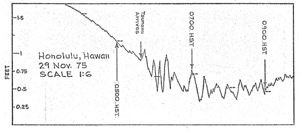
The following maximum
heights were recorded: Hilo, Hawaii 5.7 feet; Kahului, Maui 3.0
feet; Honolulu, Oahu: 0.1 feet; Nawiliwili, Kauai 0.9 feet. The
actual tsunami runup on open water coast locations was considerably
higher than what was recorded by tide gauges which were located
in more sheltered areas. For example maximum observed tsunami
wave height at the mouth of Wailoa River was 12 feet while the
maximum recorded by the Hilo gauge was 5.7 feet.
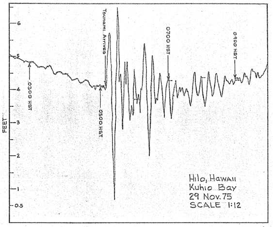 The
Tsunami of 29 November 1975, as Recorded by the Hilo Tide Gauge
on the Island of Hawaii
The
Tsunami of 29 November 1975, as Recorded by the Hilo Tide Gauge
on the Island of Hawaii
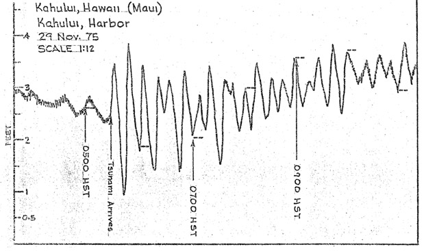 The
Tsunami of 29 November 1975, as Recorded by the Kahului Tide
Gauge on the Island of Maui.
The
Tsunami of 29 November 1975, as Recorded by the Kahului Tide
Gauge on the Island of Maui.
 The
Tsunami of 29 November 1975, as Recorded by the Honolulu Tide
Gauge on the Island of Oahu
The
Tsunami of 29 November 1975, as Recorded by the Honolulu Tide
Gauge on the Island of Oahu
 The
Tsunami of 29 November 1975, as Recorded by the Nawiliwili Tide
Gauge in the Island of Kauai.
The
Tsunami of 29 November 1975, as Recorded by the Nawiliwili Tide
Gauge in the Island of Kauai.
Far Field
Tsunami Effects
In addition to the
tide stations in the Hawaiian Islands, many other tide stations
on the U.S. West Coast, Alaska and Japan recorded a minor tsunami.
Also, minor tsunami waves were recorded in American Samoa and
in Western Samoa and several other Pacific islands. (Cox and
Morgan, 1977, p. 57-72; Pararas-Carayannis and Calebaugh, 1977;
Pararas-Carayannis and Dong, 1980; Soloviev et al., 1986, Loomis,
1975).
Alaska - The Yakutat tide gauge recorded
a wave of 2 inches in amplitude. The Sitka gauge recorded a wave
of 4 inches in amplitude.
American Samoa - The Pago Pago tide gauge recorded
a wave with amplitude of 0.11 m.
Western Samoa - The Apia station recorded a 0.17
m oscillation.
California - In California, there was minor
damage to harbor facilities on Catalina Island. Tsunami waves
of up to nine feet at the Isthmus Harbor destroyed a small floating
dock and broke loose another floating dock. According to newspaper
accounts, the water receded and several boats were stranded on
the bottom of the harbor but refloated by subsequent waves (San
Pedro Pilot, December 1, 1975). A small surge occurred at Marina
del Rey near Santa Monica (Santa Monica Evening Outlook, December
1, 1975; Spaeth, 1977; Soloviev et al., 1992).
 Tsunami Generating
Area Tsunami Generating
Area
As with the 1868 event,
Hilo was greatly affected by the shock waves of the 1975 earthquake
but not as much by the tsunamis generated by these events. This
is suggestive of the directionality of slumping and of the limited
dimensions of distinct slope failure events along the southern
flanks of the Kilauea and Mauna Loa volcanoes.
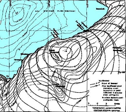
Hawaii's southern
coast showing coastal faults parallel to the east rift zone of
the Kilauea volcano, and the Generation Area of the 1975 Tsunami
in relation to the Hilina Slump where flank failures have occurred
in the past (Base map modified after Morgan et al. 2001).
Slope failures and
subsidence along Kilauea southern flank have been frequent in
the past and have generated local destructive tsunamis. However,
flank failures associated with the more recent earthquakes, appear
to have occurred in phases, over a period of time, and not necessarily
as single, large-scale events involving great volumes of crustal
material. However, large prehistoric flank failures appear to
have occurred, particularly along the western flank of the Mauna
Loa volcano. Such failures must have generated large local tsunamis
in the past.
As described previously,
a large crustal block of the flank of the Kilauea volcano slid
horizontally towards the ocean and subsided, while the offshore
region uplifted (Pararas-Carayannis 1975). Although there was
considerable subsidence along the coast, the entire offshore
region of tsunami generation is estimated to have risen by an
average of about 1.2 meters (3.9 feet). Since the initial wave
motion of the tsunami at all recording tide gauge stations in
the Hawaiian Islands was upwards, it strongly supports that the
offshore area uplifted.
The offshore crustal
displacements correspond to the tsunami generating area, which
is estimated to be about 70 km long and 30 km wide with the long
axis of the displaced crustal block being parallel to the coast.
Although these represent estimates, the volume of displaced water,
as well as the total energy that went into tsunami generation
can be calculated. The total volume of displaced material that
contributed to tsunami generation was roughly estimated to be
2.52 cubic km (Pararas-Carayannis 1976 a, b).
 Generating Mechanism
of the 1975 Tsunami in Hawaii Generating Mechanism
of the 1975 Tsunami in Hawaii
A sudden flank collapse
process generated the 1975 tsunami, which was closely associated
with Kilauea's ongoing volcanic activity and the instability
of the volcano's southern flank. Such instability along fractures
controlled by regional faults along the Puna Rift Zone results
in both aseismic and seismic slippage. The offshore geomorphological
features on the Hilina Slump - and the tide gauge recordings
of the tsunami - indicate that the 1975 flank failure and earthquake
were triggered by compressional forces of moving lava within
Kilauea's magmatic chambers below and within ascending lava dikes
- having a hydraulic piston effect on a weakened flank crustal
block. Gravitational settling followed the crustal movement.
This appears to be the mechanism by which most flank failure
events occur on Kilauea and the Mauna Loa volcanoes.
In conclusion, therefore,
the tsunami was generated by the combination of the net sudden
subsidence and uplift of the ocean floor, as well as from the
lateral crustal compression of a crustal block in a seaward direction.
The compression and the lateral crustal movement on the Hilina
Slump probably formed a horst in the offshore region. This horst
would demarcate the outer edge of the tsunami generation area
and the origin of the faster first tsunami wave. This would explain
the initial upward wave motion recorded by the tide gauges around
the islands. The faster traveling wave originated along the deeper
offshore perimeter of the tsunami generating area. The tsunami
travel times also support this conclusion.
Such flank failure
processes are characteristic of the mechanisms of earthquakes
that occur with frequency along the southern coast of the Island
of Hawaii. Tsunamigenic earthquakes occur when aseismic slippage
stops due to locking along the coastal faults and critical stresses
build up along potential decollment surfaces. The magmastatic
pressures or moving lava in the volcano's chambers or along flank
dikes, or even gravitational forces or tidal forces (including
earth tides) can trigger the release of the stored stress. Larger
earthquakes occur with the more significant flank failures. Most
of the time, Kilauea's southern flank along the Hilina Slump
region, slips aseismically without tsunami generation. However,
larger failures occur although separated by decades in time.
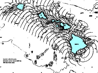
 Tsunami Travel Times
and Runup Tsunami Travel Times
and Runup
Subsequently to this
author's initial 1975 field survey, there were numerous other
reports pertaining to the time of arrival of the first tsunami
wave at different locations around the Hawaiian Islands, the
heights of subsequent waves, and the maximum observed runup.
Cox and Morgan (1977) summarized these reports and prepared the
tsunami refraction diagrams shown here. Also, for the purpose
of hazard zonation, Cox (1979) estimated the runup heights of
the 1975 tsunami for places where there had been no actual physical
measurements or observations. For the immediate tsunami generating
area where there had been substantial subsidence, the given runup
height estimates were based on the pre-subsidence mean sea level
datum. Although Cox somewhat underestimated the dimensions of
the tsunami generating area, the tsunami travel times are fairly
accurate for the initial wave which originated in deeper water
off the Kalapana coast. As pointed earlier, the actual tsunami
runup on open water coast locations around the Hawaiian Islands
were considerably higher than what was recorded by tide gauges
in sheltered harbors.
Past and
Future Tsunamis Vulnerability of the Hawaiian Islands to
Local Tsunamis
Failure of the southern
flank of Kilauea (and Mauna Loa) is an ongoing process that has
been responsible for numerous earthquakes and local tsunamis
throughout Hawaii's geological history.
The numerous faults
(palis) along the Puna Rift Zone with their tilting walls indicate
a seaward progression of edifice failure. Also, the numerous
"horsts" and "grabens" in the offshore region
of the Hilina Slump as well as toes of debris avalanches
on the ocean floor - indicate that past flank failures and associated
earthquakes resulted from gravitational and volcanically-induced
compressional forces.
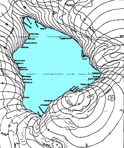
Composite Satellite
Photo of the Island of Hawaii (8 photos)
The offshore geomorphological
features are characteristic of large crustal block movements
from past earthquakes and parallel those of the 1975 Kalapana
event. The failures appear to have occurred as discreet events
along the submarine portion of the Hilina Slump over a long period
of time. Such discreet failures have generated destructive tsunamis
in the past. The destructive local tsunamis of 1823(?) and 1868
were generated by such flank failures of Kilauea and Mauna Loa
volcanoes. In 1989, the southern region of Hawaii experienced
smaller, damaging earthquakes, but no tsunami was generated.
 In view of the instability of
the southern flanks of Kilauea (and of Mauna Loa), the area is
vulnerable to local tsunamis. In older times this was not as
critical since the population density was low. However, since
1975 the population density on the southern coast of the Island
of Hawaii has increased dramatically. Thus, a repeat of an earthquake
and tsunami as in 1975, can be expected to result in many more
casualties and extensive property losses. In view of the instability of
the southern flanks of Kilauea (and of Mauna Loa), the area is
vulnerable to local tsunamis. In older times this was not as
critical since the population density was low. However, since
1975 the population density on the southern coast of the Island
of Hawaii has increased dramatically. Thus, a repeat of an earthquake
and tsunami as in 1975, can be expected to result in many more
casualties and extensive property losses.
Tsunami preparedness
for the Hawaiian Islands and particularly the Island of
Hawaii must take into consideration the increased level
of risk associated with the recent development of the coastal
areas. Appropriate measures must be taken to factor the added
risk to any community development and the construction of supporting
infrastructure.
REFERENCES
AND ADDITIONAL READING
Cox and
Morgan, 1977
Loomis, 1975
McMurtry
G. M., Herrero-Bervera E., Cremera M. D., Smith J. R., Resig
J., Sherman C. and Torresan M. E., 1999. Stratigraphic constraints on the timing
and emplacement of the Alika 2 giant Hawaiian submarine landslide.
Journal
of Volcanology and Geothermal Research, Vol. 94 (1-4) (1999)
pp. 35-58.
Moore, J.G.,
and Chadwick, W.W. Jr., 1995. Offshore geology of Mauna Loa and adjacent areas,
Hawaii.
In Geophysical Monograph 92, Mauna Loa Revealed: structure, composition,
history, and hazards, ed. by J.M. Rhodes and J.P. Lockwood, American
Geophysical Union, Washington, D.C., p. 21-44.
Moore, J.G.,
and Clague, D.A., 1992. Volcano growth and evolution of the island of
Hawaii.
Geologic Society of America Bulletin, 104, 1471-1484.
Moore, J.G.,
Clague, D.A., Holcomb, R.T., Lipman, P.W., Normark, W.R., and
Torresan, M.E., 1989. Prodigious submarine landslides on the Hawaiian
Ridge.
Journal of Geophysical Research, Series B 12, Volume 94, p. 17,465-17,484.
94, 17,465-17, 484.
Moore, J.G.,
Normark, W.R. & Holcomb, R.T., 1994. Giant Hawaiian Landslides. Annual Reviews of
Earth and Planetary Science, 22, 119-144.
Morgan,
J.K., Moore, G.F., and Clague, D.A., 2001. Papa`u Seamount: the submarine expression
of the active Hilina Slump, south flank of Kilauea Volcano, Hawaii. Journal of Geophysical
Research, submitted.
Pararas-Carayannis,
G. 1968. Catalog
of Tsunamis in the Hawaiian Islands. Data Report Hawaii Inst.Geophys.
Jan. 1968
Pararas-Carayannis,
G., 1969. Catalog
of Tsunami in the Hawaiian Islands. World Data Center A- Tsunami U.S.
Dept. of Commerce Environmental Science Service Administration
Coast and Geodetic Survey, May 1969.
Pararas-Carayannis
G., 1975.
Tsunami Newsletter,
Vol. VIII, No. 4, December, 1975.
Pararas-Carayannis,
G., 1976a. The
Earthquake and Tsunami of 29 November 1975 in the Hawaiian Islands. ITIC Report, 1976.
Pararas-Carayannis,
G., 1976b. In International Tsunami Information Center - A Progress Report For
1974-1976.
Fifth Session of the International Coordination Group for the
Tsunami Warning System in the Pacific, Lima, Peru, 23-27 Feb.
1976
Pararas-Carayannis,
G. and Calebaugh P.J., 1977. Catalog of Tsunamis in Hawaii, Revised and Updated, World Data Center
A for Solid Earth Geophysics, NOAA, 78 p., March 1977.
Pararas-Carayannis,
G. and Dong B. 1980. A
Study of Historical Tsunami in American Samoa for U.S. Corps.
of Engineers, Waterways Experiment Station Type 16 Flood Studies. Honolulu: Research
Corporation University of Hawaii, October 29, 1979, Waterways
Experiment Station Report 1980.
Pararas-Carayannis,
G, 1988. Risk
Assessment of the Tsunami Hazard. In Natural and Man-Made Hazards, 1988,
D. Reidal, Netherlands, pp.171-181.
Pararas-Carayannis,
George, 2002. Evaluation
of the Threat of Mega Tsunami Generation from Postulated Massive
Slope Failures of Island Stratovolcanoes on La Palma, Canary
Islands, and on the Island of Hawaii, Science of Tsunami Hazards. Vol 20
(5). pages 251-277, 2002 ALSO AT URL http://www.drgeorgepc.com/TsunamiMegaEvaluation.html
Pararas-Carayannis,
G., 2005. INSTABILITY
OF KILAUEA VOLCANO'S SOUTHERN FLANK - EVALUATION OF MASS EDIFICE
FAILURES, FLANK COLLAPSES AND POTENTIAL TSUNAMI GENERATION
Pararas-carayannis, G., 2004. VOLCANIC
TSUNAMI GENERATING SOURCE MECHANISMS IN THE EASTERN CARIBBEAN
REGION
Pararas-Carayannis, G., 2004. Factors
Contributing to Explosivity, Structural Flank Instabilities,
Mass Edifice Failures and Debris Avanlanches of Volcanoes - Potential
for Tsunami Generation
Reynolds,
J. R., Clague, D.A., Hatcher, G. and Maher, N., 1998. Evolutionary Sequence
of Submarine Volcanic Rift zones in Hawaii. EOS, Transactions American Geophysical
Union, 79, F825.
San Pedro Pilot, December 1, 1975 / Santa Monica Evening Outlook,
December 1, 1975
Shigihara,
V., and Imamura, F., 2002. Numerical Simulation Landslide Tsunami 2nd Tsunami Symposium,
Honolulu, Hawaii, USA, May 28-30, 2002
Smith, J.
R. Malahoff A., and Shor A. N., 1999. Submarine geology of the Hilina slump
and morpho-structural evolution of Kilauea volcano, Hawaii. Journal of
Volcanology and Geothermal Research, V. 94, No 1-4, 1, pp. 59-88
December U.S. Geological Survey, Hawaii Volcano Observatory,
Survey
Soloviev
et al., 1992.
Soloviev et al., 1986
Spaeth, 1977
Tilling,
R.I., Koyanagi, R.Y., Lipman, P.W., Lockwood, J.P., Moore, J.G.,
and Swanson, D.A., 1976. Earthquake and related catastrophic events, Island
of Hawaii,
November 29, 1975: a preliminary report: U.S. Geological Survey
Circular 740, 33 p.
SEE ALSO
INSTABILITY OF KILAUEA VOLCANO'S SOUTHERN FLANK
- EVALUATION OF MASS EDIFICE FAILURES, FLANK COLLAPSES AND POTENTIAL
TSUNAMI GENERATION
EVALUATION OF THE THREAT OF MEGA TSUNAMI GENERATION
FROM POSTULATED MASSIVE SLOPE FAILURES OF ISLAND STRATOVOLCANOES
ON LA PALMA, CANARY ISLANDS, AND ON THE ISLAND OF HAWAII
VOLCANIC TSUNAMI GENERATING SOURCE MECHANISMS
IN THE EASTERN CARIBBEAN REGION
Factors Contributing to Explosivity, Structural
Flank Instabilities, Mass Edifice Failures and Debris Avanlanches
of Volcanoes - Potential for Tsunami Generation
Return to

  Links to other
Pages
Links to other
Pages

 Now available
from Amazon, Barnes and Noble and other major bookstores. A signed
by the author copy can be also ordered by contacting directly
by email Aston
Forbes Press.
Now available
from Amazon, Barnes and Noble and other major bookstores. A signed
by the author copy can be also ordered by contacting directly
by email Aston
Forbes Press.
 Other
Miscellaneous Non-technical Writings
Other
Miscellaneous Non-technical Writings
(©) Copyright
1963-2007 George Pararas-Carayannis / all rights reserved / Information
on this site is for viewing and personal information only - protected
by copyright. Any unauthorized use or reproduction of material
from this site without written permission is prohibited.
|