|
TSUNAMI WARNING
SYSTEM IN THE PACIFIC OCEAN
George
Pararas-Carayannis
(Excerpts from
articleS published in Earthquakes and Volcanoes, and in Sea Frontiers.
NOTE: Since this article was written a number of changes have
taken place. More countries have joined the International Tsunami
Warning System and more seismic and tidal stations have been
added to the network. Look for Updates)
 Awarded a Times Pick by the Los Angeles
Times on 8/5/98 Selected
by the National Science Teachers Association (NSTA) Awarded a Times Pick by the Los Angeles
Times on 8/5/98 Selected
by the National Science Teachers Association (NSTA)

 Historical Background Historical Background
Of all natural disasters,
tsunamis are among the most terrifying and complex phenomena,
responsible for great loss of lives and vast destruction of property.
Enormous destruction of coastal communities has taken place throughout
the world by such great waves since the beginning of recorded
history.
The impact of tsunamis
on human societies can be traced back in written history to 1480
BC, when the Minoan civilization in the Eastern Mediterranean
was wiped out by great tsunami waves generated by the volcanic
explosion of the island of Santorin. In the Pacific Ocean where
the majority of these waves have been generated, the historical
record, although brief, shows tremendous destruction. In Japan
which has one of the most populated coastal regions in the world
and a long history of earthquake activity, tsunamis have destroyed
entire coastal communities. There is also history of tsunami
destruction in Alaska, in Hawaiian Islands, and in South America.
The Need for a Warning
System 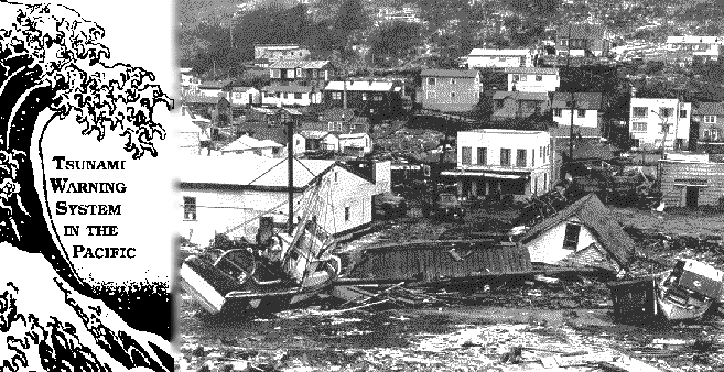
While most of the
destructive tsunamis have occurred in the Pacific Ocean, devastating
tsunamis have also occurred in the Atlantic, the Indian Ocean,
and in the Mediterranean Sea. In the last 30-40 years there has
been tremendous growth and development of the coastal areas in
most of the developing or developed Pacific nations. This is
the result of population growth and of technological and economic
developments that have made the use of the coastal zone more
necessary than before. Many of the countries of the Pacific,
for example, have populations with natural maritime orientation.
For many of these countries foreign trade is a necessity so they
maintain major port facilities. Others have extensive ship building
facilities, electric plants, refineries, and other important
coastal structures. A number of countries throughout the Pacific
have now begun important aqua culture industries and canneries.
This combination of social and economic factors makes a number
of developed and developing countries of the Pacific vulnerable
to the threat of tsunamis.
To protect life and
property in the Pacific an International Pacific Tsunami Warning
System has been organized using an extensive network of seismic
and tidal stations, as well as communications, to ensure that
the warning information is prompt and accurate. This Pacific
Tsunami Warning System is an offspring of a basic U.S. warning
system that was initially designed to protect the Hawaiian Islands.
The following is a review of the history and evolution of this
System.

The U.S. and Other Tsunami
Warning Systems
Earlier U.S. System:
After the Aleutian tsunami of April 1, 1946 caused major damage
and many casualties in the Hawaiian Islands, it was obvious that
a means of providing warnings to the population of Hawaii was
necessary. This early U.S. Tsunami Warning System was confronted
with a number of problems that had to be solved. The Warning
System had to detect and rapidly locate earthquakes in the Pacific
region, and if one occurred in an area where tsunami generation
was possible, to determine quickly whether indeed a tsunami had
been generated. Also it was necessary to develop a method for
accurate arrival times of the tsunami at various places. Initially
a tsunami travel time chart for Honolulu was prepared. Later,
travel time charts were also prepared for other stations in the
System. For the prototype system a detector was actuated by unusual
wave motion of the tsunami to ring an alarm.
 
Damage to the Scotch
Cap lighthouse from the Aleutian tsunami of April, 1946, Umimak
Island, Alaska; before and after. (Coast Guard Photos)
Early Methods of Earthquake
Measurements and Tsunami Warning: In 1946 photographic methods were still used
to record earthquakes because they were simple, practical and
precise. Visual recording equipment was needed to be used in
conjunction with existing seismographs. In 1947 and 1948 these
new instruments were built and installed at three seismic observatories.
Later these installations were modified by adding a new electronic
amplifier. It included an alarm circuit so that whenever a major
earthquake was recorded, an audible and/or visible alarm was
tripped, thus insuring prompt observation of every major earthquake.
Also a tentative communication plan was prepared utilizing existing
communication of the U.S. Armed Forces and of the Civil Aeronautics
Administration. The original Tsunami Warning System consisted
of three seismological observatories of the Coast and Geodetic
Survey at Sitka, College, Tucson, and Honolulu, and tide stations
at Attu, Adak, Dutch Harbor, Sitka, Palmyra Island, Midway Island,
Johnston Atoll, Hilo, and Honolulu. Honolulu Observatory was
made the headquarters of this initial Tsunami Warning System.
Its function was to supply tsunami watch and warning information
to the civil authorities and various military headquarters in
the Hawaiian Islands for dissemination to military bases throughout
the Pacific and to the islands in the United States Trust Territories
of the Pacific. Later, in 1953 warning information was also given
to the civil defense agencies of California, Oregon, and Washington.
Other countries in
the Pacific, such as Japan and USSR had also established rudimentary
national warning systems, with the responsibility of warning
primarily their own civil defense authorities and protecting
their own national interests. These systems had limited data
collection capabilities, limited communications within their
own national jurisdictions, and limited warning dissemination
capability.
International Cooperation
 The great destruction caused
by the May 1960 Chilean tsunami prompted a large number of countries
and territories to join the Pacific TWS, at least by contributing
data and information. The great Alaskan earthquake of 1964 generated
a devastating tsunami that affected a good part of the Pacific.
This tsunami focused additional attention to the need for an
International Tsunami Warning System. The great destruction caused
by the May 1960 Chilean tsunami prompted a large number of countries
and territories to join the Pacific TWS, at least by contributing
data and information. The great Alaskan earthquake of 1964 generated
a devastating tsunami that affected a good part of the Pacific.
This tsunami focused additional attention to the need for an
International Tsunami Warning System.
Tsunami of May 24,
1960, caused enormous damage at Hilo, Hawaii. (Photograph by
Honolulu Advertiser).
In 1965, the United
Nations Educational, Scientific, and Cultural Organization's
(UNESCO) Intergovernmental Oceanographic Commission (IOC) accepted
an offer made by the United States to expand its existing Tsunami
Warning Center in Honolulu to become the headquarters of an International
Pacific Tsunami Warning System and at the same time accepted
the offer of other IOC member countries to integrate their existing
facilities and communications into this System. A meeting was
held in Honolulu, Hawaii in 1965 establishing the International
Tsunami Information Center (ITIC) and an International Coordination
Group for the Tsunami Warning System (ICG/ITSU).
ITIC was given the
general mandate of mitigating the effects of tsunamis throughout
the Pacific by supporting member states of ICG/ITSU in developing
and improving preparedness for tsunamis; by monitoring and seeking
to improve the Tsunami Warning System for the Pacific; by gathering
and disseminating knowledge on tsunamis, by fostering tsunami
research; and by bringing to non-member states a knowledge of
the Tsunami Warning System and ITIC, and information on how to
become participants through IOC/ITSU.
The International
Coordination Group, established as a subsidiary body of IOC,
meets every two yeas in a member state to coordinate and review
the activities of the International Tsunami Warning System (ITWS).
The Pacific Tsunami
Warning System
The existing U.S.
Warning System was integrated with the Systems of Japan, USSR,
Chile, and of other regional centers, and became a truly International
Tsunami Warning System. The following twenty-eight nations are
now participating members of ITSU in the Pacific : Australia,
Canada, Chile, China, Colombia, Cook Islands, Costa Rica, Democratic
People's Republic of Korea, Ecuador, Fiji, France, Guatemala,
Indonesia, Japan, Mexico, New Zealand, Nicaragua, Peru, Philippines,
Republic of Korea, Singapore, Thailand, Federation of Russia,
United States of AmericaUSA,and Western Samoa.
Several nonmember
states and territories maintain stations for the ITWS. The System
makes use of 69 seismic stations, 65 tide stations, and 101 dissemination
points scattered throughout the Pacific Basin under the varying
control of the member states of ITSU. The Pacific Tsunami Warning
Center at Ewa Beach near Honolulu is operated by the U.S. National
Weather Service, Pacific Region (see adjacent NOAA diagram).
Also, a program of
preparedness has been developed alerting coastal populations,
industries, and Civil Defense agencies to respond to tsunami
warnings. The International Tsunami Information Center (ITIC)
has the responsibility of coordinating public educational programs
for each participating country. ITIC works closely with government
agencies, private institutions, and Civil Defense authorities,
developing sound coastal management policies which include zoning
and planning for coastal areas, as well as standard operating
procedures in case of an actual event.
The objectives of
the Pacific Tsunami Warning System are to detect and locate major
earthquakes in the Pacific region as soon as possible, to determine
whether they have generated tsunamis, and to provide timely and
effective information and warnings to. the population of the
Pacific in order to minimize the hazards to life and property.
 How
the System Works How
the System Works
Functioning of the
system begins with the detection of an earthquake which has a
magnitude and location that make it potentially tsunamigenic.
The earthquake has to be of sufficient magnitude to trigger the
alarm attached to the seismograph at the station where it is
being recorded. The alarm thresholds are set so that ground vibrations
of the amplitude and duration associated with an earthquake of
approximate magnitude 6.5 or greater on the Richter scale anywhere
in the Pacific region will cause them to sound. This magnitude
is below the threshold for issuing watch and warning messages.
Personnel at the station immediately interpret their seismograms
and send their readings to the Pacific Tsunami Warning Center.
Upon receipt of a report from one of the participating seismic
observatories or as a consequence of the triggering of their
own seismic alarm, PTWC personnel send messages requesting data
from the observatories in the system.
Destruction from the
1964 tsunami at Seward, Alaska.
When sufficient data
have been received so that the earthquake can be located and
the magnitude computed, a decision is made as to further action.
If the earthquake is strong enough to cause a tsunami and is
located in an area where this is possible, participating tide
stations near the epicenter are requested to monitor their tide
gauges. Watch bulletins are issued to the dissemination agencies
for all earthquakes of magnitude 7 or greater occurring in the
Aleutian Islands and all earthquakes of magnitude 7.5 or greater
occurring elsewhere in the Pacific. A watch may also be disseminated
by the PTWC upon the issuance of warnings by regional warning
centers. Since the regional systems use different criteria for
their disseminations, a watch may at times be issued for earthquakes
with magnitude less than 7.5.
When reports from
tide stations show that a tsunami poses a threat to the population
in part or all of the Pacific, a warning is transmitted to the
dissemination agencies for relay to the public. These agencies
then implement plans to evacuate people from endangered areas.
If the tide station reports indicate that either a negligible
tsunami or no tsunami has been generated, PTWC issues a cancellation.
Capabilities and Limitations
of the System
A tsunami originates
in or near the epicentral area of the earthquake that creates
it. It propagates outward in all directions at a speed that depends
on ocean depths. In the deep ocean, the speed may exceed 600
kms per hour; thus, the need for rapid data handling and communication
becomes obvious. Because of the time spent in collecting seismic
and tidal data, the warnings issued by PTWC cannot protect areas
against local tsunamis in the first hour after generation; for
this purpose, regional warning systems have been established
in some areas.
The regional systems
generally have data from a number of seismic and tide stations
telemetered to a central headquarters. Nearby earthquakes are
located, usually in 15 minutes or less, and a warning based on
seismological evidence is released to the population of the area.
Since the warning is issued on the basis of seismic data alone,
watches or even warnings will occasionally be issued when tsunamis
have not been generated. Since they are issued only to a restricted
area and confirmation of the existence or nonexistence of a tsunami
is rapidly obtained, dislocations of populations are minimized.
To limit the number of agencies to be contacted, warnings are
generally issued to only one agency in each country, territory,
or administrative area.
Dissemination agencies
have the continuing responsibility for educating the public concerning
the dangers of tsunamis and for developing safety measures that
must be taken to avoid loss of life and to reduce property damage.
The agencies are encouraged to develop emergency plans for all
threatened localities, clearly delineating areas of possible
inundation. Evacuation routes should be designated, safe areas
marked, and the amount of advance warning to insure evacuation
from danger areas determined.
Present and Planned
Improvements
A general operational
concept is presently being developed for the International Tsunami
Warning System using updated technology and instrumentation.
The objective is to reduce the time needed to evaluate the tsunami
hazard, make decisions, and disseminate the warnings, on a Pacific-wide
or a regional basis. The new system is using a large network
of shore-based seismic and tsunami sensors transmitting real-time
data to the International Tsunami Warning Center (ITWC) in Honolulu,
making use of synchronous meteorological satellites for communication
relay.
Additional refinements
to the operating system will include offshore tsunami bottom
sensors using crystal pressure-transducers, acoustic or wire
links with existing buoy systems, data microprocessors, and data
links via geostationary satellites between shore installations
and the ITWC. Both the offshore and the coastal tsunami sensors
will be continuously-recording, event-activated, or activated
on demand. The prototypes for coastal installation are complete,
tested, and working. Additional work is needed in the adaptation
of microcomputers, power supplies, acoustic links with buoys,
and the housing of the offshore tsunami sensors. A unique data-processing
interphase system has been developed for the ITWC in Honolulu
using a multi task computer system to handle increased data loads
available through the synchronous satellites and other data networks.
The new technology is resulting in a more efficient International
Tsunami Warning System.
Finally, the International
Tsunami Warning System is one of the most successful international
programs ever undertaken involving a multitude of nations with
the direct responsibility of mitigating the effects of tsunamis,
the saving of lives, and the preservation of property. It is
an effective operational program with a direct humanitarian objective-the
protection of human lives in the Pacific Ocean coastal areas.
The system has been made possible by the generous contributions
and participation of the Community of Nations of the Pacific,
by IOC's involvement, and by the active and effective coordination
of ITIC and of the International Coordination Group.
REFERENCES
Pararas-Carayannis,
G. 1977. "The
International Tsunami Warning System", Sea Frontiers, Vol. 23, No. 1, 1977,
pp.20-7.
Pararas-Carayannis,
G. 1986, The Pacific
Tsunami Warning System,
Earthquakes and Volcanoes, Vol. 18, No. 3, , p. 122-130,
1986.
RETURN TO
  Links to other
Pages
Links to other
Pages
  Now available from Amazon, Barnes
and Noble and other major bookstores. A signed by the author
copy can be also ordered by contacting directly by email Aston Forbes
Press.
Now available from Amazon, Barnes
and Noble and other major bookstores. A signed by the author
copy can be also ordered by contacting directly by email Aston Forbes
Press.
 Other
Miscellaneous Non-technical Writings
Other
Miscellaneous Non-technical Writings
(©) Copyright
1963-2007 George Pararas-Carayannis / all rights reserved / Information
on this site is for viewing and personal information only - protected
by copyright. Any unauthorized use or reproduction of material
from this site without written permission is prohibited.
|