|
|
Earthquake
of January 17, 1994 in California - The
Northridge Earthquake
George Pararas Carayannis
Introduction
On Monday January 17, 1994, a moderate earthquake struck the densely populated San Fernando Valley, about 32 km northwest of downtown Los Angeles. Extremely strong ground motions - among the strongest ever recorded - were responsible for most of the damage. The quake's intense shaking caused extensive ground liquefaction and triggered many fires. The Northridge earthquake - as it was named - was one of the worst natural disasters in U.S. history. It was the third destructive earthquake to strike California in the last 23 years, following the 1989 Loma Prieta earthquake (magnitude 7.1) and the 1971 San Fernando (Sylmar) earthquake (magnitude 6.6).
Date and Time of Origin: 4:30 A.M., Pacific Standard Time (1230 UTC), on Monday January 17, 1994.
Epicenter: The epicenter was at 34 13.00N and 118 32.00 W, near Northridge at the northern edge of the valley approximately 100 km to the west and south of the San Andreas fault.
Magnitude: Moment magnitude (Mw) 6.7
Focal Depth: 17.5 km.
Fault Plane: The quake occurred along a deeply buried blind thrust fault that is believed to be an eastern extension of the Oak Ridge fault system.
Aftershocks: Thousands of aftershocks occurred in the following days, weeks and months. Some of these had magnitudes of 4.0 to 5.0.
Felt Reports and Intensities: The Modified Mercalli Intensities ranged from VIII to XI. Accelerations in the range of 1.0 g were recorded over a large area. Landslides and ground failures occurred as far away as 90 kilometers from the epicenter. The earthquake was felt over an area of more than 200,000 square kilometers and as far away as 400 kilometers from the epicenter.
 Death
Toll and Damages
Death
Toll and Damages
Although the quake had a moment magnitude (Mw) of only 6.7, it was very damaging because it struck a well developed area within the San Fernando Valley with a population of nearly 3 million. The number of fatalities were about the same as in 1971. A total of 57 people lost their lives and more than 1,500 people were seriously injured. Fortunately, because the earthquake occurred in the early morning and on a holiday, its effects were not as bad as they could have been. Most of the buildings that collapsed were empty at the time. Furthermore, after the 1971 earthquake, many businesses had retrofitted and strengthened some of the older buildings, thus significantly reducing potential losses.
Although the quake did not kill many people, the extent of damage to buildings and structures created economic chaos for the area. Extremely strong ground motions - among the strongest ever recorded - were responsible for most of the damage. Some of the larger aftershocks with magnitudes ranging from 4.0 to 5.0 caused additional damage.
Most of the severe destruction occurred within 16 km of the epicentral area, however significant damage to structures was reported as far away as 77 km. Thousands of landslides occurred over an area of about 10,000 square kilometers, primarily in sparsely populated areas north of the valley. The landslides destroyed homes, roads, and utility lines, and obstructed streams. They also triggered dense clouds of dust, which caused an outbreak of valley fever. Although building damage was widespread throughout the Valley, Santa Monica and Sherman Oaks were two of the hardest hit communities. In Santa Monica, located directly south of the epicentral area, there was extensive damage. About 12,500 structures were moderately to severely damaged and thousands of people were left temporarily homeless. Also, utilities were significantly affected. For several days after the earthquake, more than 48,500 homes had little or no water, while 9,000 homes and businesses were without electricity and 20,000 more were without gas.
 Damage
to Highways - Major freeway damage occurred up to
32 km from the epicentral region.
Freeways collapsed at seven sites, while 170 bridges sustained
varying degrees of damage. Collapses and other severe damage
forced closing portions of 11 major roads to downtown Los
Angeles. The Santa Monica Freeway (Interstate 10) was badly
damaged. As with the 1971 earthquake, the interchange between
San Fernando and Newhall (Interstate 5 and State Route 14),
sustained heavy damage. The collapse of this interchange
was one of the most expensive freeway failures.
Damage
to Highways - Major freeway damage occurred up to
32 km from the epicentral region.
Freeways collapsed at seven sites, while 170 bridges sustained
varying degrees of damage. Collapses and other severe damage
forced closing portions of 11 major roads to downtown Los
Angeles. The Santa Monica Freeway (Interstate 10) was badly
damaged. As with the 1971 earthquake, the interchange between
San Fernando and Newhall (Interstate 5 and State Route 14),
sustained heavy damage. The collapse of this interchange
was one of the most expensive freeway failures.
Financial Losses - In terms of financial losses and property damage, this earthquake was one of the worst natural disasters in U.S. history. Damage and economic losses were estimated to be about $20 billion.
Past Earthquakes in the Region
San Fernando valley has been struck frequently in the past by moderate to large earthquakes. The February 9, 1971 earthquake (magnitude 6.6) about 32 km to the northeast, had been the last major destructive event. However, the 1994 Northridge earthquake caused far greater damage than the 1971 event which had released most of its energy in the San Gabriel mountains.
The Faults of San Fernando Valley
The 1994 Northridge earthquake occurred beneath the northern fringes of San Fernando Valley, on a deep buried blind thrust fault that is believed to be an eastern extension of the Oak Ridge fault system. The area's biggest and best-known geologic fault, is the San Andreas fault, about 100 km to the east and north of the Valley.
There
are several other faults in San Fernando Valley. The San
Fernando fault transverses the valley and has two major segments.
The Sylmar segment which crosses the heavily populated Sylmar
- San Fernando area, and the Tujunga portion which consists
of only one or two parallel breaks and extends along the
foothills of the San Gabriel Mountains, the Tujunga Valley
to the east of San Fernando.
The Northridge Hills Fault is considered to be the most potentially dangerous fault in the area. It extends through the populated region of the valley from the vicinity of Chatsworth to Northridge where it changes into an eastward direction to the east central valley from where it disappears beneath deep alluvium deposits. Since 1971, this fault has become the focus of extensive studies because of its location across a major metropolitan region of California. As already mentioned, it is believed that the Northridge earthquake occurred on a similar thrust fault which may be a blind eastern extension of the Oak Ridge fault system.
Focal Mechanism
According to USGS studies, the upward thrust movement of the Northridge earthquake on the blind thrust fault, deformed an area of about 4,000 square kilometers into the shape of an asymmetric dome. The fault's rupture begun at a depth of about 17.5 kilometers and moved upward in a northwestward direction for about 8 seconds, at a speed of about 3 kilometers per second. The rupture stopped about 5 kilometers beneath the surface. There was no clear surface rupture. Fortunately, most of the quake's energy propagated to the north of San Fernando Valley, an area sparsely populated.
Extreme Accelerations
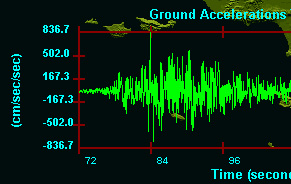 The
1994 Northridge event resulted in
very strong ground motions characteristic
of thrust-type of earthquakes such
as those which occurred in San Fernando
in 1971 and in Coalinga in 1983. However,
the vertical and horizontal accelerations
of the 1994 quake were among the
strongest ever recorded. Local conditions
and topography in the valley amplified
the seismic energy. Accelerations
in the range of 1.0 g occurred over
a much larger area. On a small hill, just south
of the epicenter in Tarzana, the highest acceleration
of 1.78 g was recorded. The strong motions caused
extensive ground liquefaction and landslides
which damaged many structures in San Fernando
Valley. The extremely strong ground motions of
the Northridge earthquake are indicative of the
significant threat that even moderate magnitude,
thrust-fault events present, particularly in
valleys.
The
1994 Northridge event resulted in
very strong ground motions characteristic
of thrust-type of earthquakes such
as those which occurred in San Fernando
in 1971 and in Coalinga in 1983. However,
the vertical and horizontal accelerations
of the 1994 quake were among the
strongest ever recorded. Local conditions
and topography in the valley amplified
the seismic energy. Accelerations
in the range of 1.0 g occurred over
a much larger area. On a small hill, just south
of the epicenter in Tarzana, the highest acceleration
of 1.78 g was recorded. The strong motions caused
extensive ground liquefaction and landslides
which damaged many structures in San Fernando
Valley. The extremely strong ground motions of
the Northridge earthquake are indicative of the
significant threat that even moderate magnitude,
thrust-fault events present, particularly in
valleys.
Ground motions of an earthquake are greater in valleys - which are usually areas with the highest population density. Geologically, valleys represent basins where thick layers of sediments accumulate as a result of active erosion of mountainous regions. In valleys, the thick layers of sediments tend to amplify the seismic surface waves, thus resulting in greater horizontal and vertical accelerations and ground movements. For example, the 1994 Northridge earthquake was particularly destructive at Sherman Oaks and Santa Monica, areas of San Fernando valley characterized by soft sedimentary layers. The energy of the earthquake generated greater ground motions at these two locations.
 In a valley, an earthquake's seismic waves
do not rapidly dissipate
but tend to bounce off the
sides and floor of the basin,
often
overlapping and interfering with one another. At the perimeter
of a valley basin, ground motions may not be exceptionally
high because of "edge effects". In certain areas, the seismic
surface waves may cancel each other, thus resulting in reduced
ground movements. However in other areas of a valley, like ocean
waves, the surface seismic waves may also superimpose on each
other and thus increase the intensity and extent of ground movements
In a valley, an earthquake's seismic waves
do not rapidly dissipate
but tend to bounce off the
sides and floor of the basin,
often
overlapping and interfering with one another. At the perimeter
of a valley basin, ground motions may not be exceptionally
high because of "edge effects". In certain areas, the seismic
surface waves may cancel each other, thus resulting in reduced
ground movements. However in other areas of a valley, like ocean
waves, the surface seismic waves may also superimpose on each
other and thus increase the intensity and extent of ground movements
Epicenter and Horizontal Accelerations of the 1994 Northridge earthquake (after USGS).
Understanding and predicting the surface behavior
of seismic waves in valleys
is rather difficult. Frequently,
there are
many variables that are not fully understood or are very
difficult to estimate. For
example, changes in the location,
duration
and
magnitude of an earthquake will also change the interference
patterns of the seismic waves, making it often impossible
to know, on a block-by-block
basis, where the most susceptible
areas of the valley will be or where the ground movements
will
be the
strongest. In designing buildings or other structures, engineers
and architects do not always have a clear picture of the
seismic forces in action
during an earthquake and
may not take them
adequately into consideration. This is why an adequate Uniform
Building
Code is needed.
Lessons Learned
What is significant about the 1994 Northridge earthquake is that it was of moderate size, yet it caused great destruction in San Fernando valley, a region believed to be well-prepared after the 1971 event. Most of the structures that were affected had been built during the past three decades and were considered to be reasonably earthquake resistant. However, the unusually strong ground motions of this earthquake caused serious damage to buildings within about 16 km of the epicentral area.
 The
strong ground motions associated with the vertical and horizontal
accelerations of this quake surprised many scientists, engineers
and government officials. Some buildings were completely
destroyed while others, only a short distance away, were
unaffected. The different types of failures provided very
important information in the evaluation of seismic hazards.
The
strong ground motions associated with the vertical and horizontal
accelerations of this quake surprised many scientists, engineers
and government officials. Some buildings were completely
destroyed while others, only a short distance away, were
unaffected. The different types of failures provided very
important information in the evaluation of seismic hazards.
Extensive ground failures in the valley occurred primarily in
filled land areas, underlain by ground water and fine-grained
sediments at depths of less than 10 meters. For example, a major
belt of ground failures occurred in the Granada Hills-Mission
Hills, an area with soft soils.
Vertical Accelerations of the 1994 Northridge earthquake (Modified after the USGS).
In general, ground failure was the principal cause of damage
to single-family homes. Structures within ground-failure zones
suffered almost three times more damage than structures outside
the zones. Also damage to foundations was about six times greater
in the ground-failure zones. The well-engineered buildings
withstood the strong ground motions without structural
damage. However,
numerous other buildings and structures throughout the region
failed. Their failures were indicative of significant design
or construction deficiencies and defects.
Generally most of the steel-framed buildings designed for
seismic resistance, performed well. However, more
than 100 buildings
had failures due to the fracturing of their steel frames.
Many buildings with reinforced concrete columns sustained
also considerable
damage. Fills and dams in the Van Norman Complex, retrofitted
after failures in the 1971 San Fernando earthquake, performed
well. Overall, most of the highway structures performed well
but, as with the 1971 earthquake, the Santa Monica Freeway
(Interstate 10) and the interchange (Interstate 5 and State
Route 14) were
considerably damaged.
The severe damage which occurred in Sherman Oaks and Santa
Monica was confined primarily along isolated pockets with
a variety
of local geological and topographic conditions that were
thoroughly investigated since they are indicative of potential
problems
in future earthquakes.
The Northridge quake revealed the need for engineers and
architects to design buildings and structures that would
not collapse
during an earthquake, but would also continue to be functioning
and
be usable afterwards - thus minimizing the economic disruption
of the affected area. There were several lessons learned
from the 1994 Northridge earthquake, the most important
being that better emergency preparedness and response procedures
need
to be implemented and that California's Uniform Building Code needed revisions
to provide for higher levels of earthquake resistance. Also, the Northridge quake
emphasized the need for stricter criteria and guidelines in identifying
the
seismic risk within a region.
References and Additional Reading
Andrus,
F.M., 1952, "Earthquake design requirements of the Uniform
Building Code." In Proceedings of the Symposium on Earthquake
Blast Effects on Structures. Berkeley, 1952. pp. 314-316.
Heaton, T.N., 1982, The 1971 San Fernando earthquake: A double
event?: Seismological Society of America Bulletin, v. 72, no.
6, p. 2037-2062.
Hill, M. L. 1954. “Tectonics of Faulting in Southern California.” California
Division of Mines and Geology Bulletin, No. 170: 5-14.
Langston, C.A., 1978, The February 9, 1971 San Fernando earthquake:
A study of source finiteness in teleseismic body waves: Seismological
Society of America, v. 68, no. 1, p. 1-29.
Plafker, George, and Galloway, J.P. eds., 1989, Lessons learned
from the Loma Prieta, California, earthquake of October 17,
1989: U.S. Geological Survey Circular 1045, 48 p.
Richter, C.F., 1973, Historical seismicity of San Fernando
earthquake area, in Benfer, H.A., Coffman, J.L., and Bernick,
J.R., eds.,
San Fernando, California, earthquake of February 9, 1971:
Washington, U.S. Department of Commerce, National oceanic
and Atmospheric
Administration, Environmental Research Laboratories, v. 3,
p. 5-11
U.S. Geological Survey, 1971, The San Fernando, California,
earthquake of February 9, 1971: Professional Paper 733,
254 p.
Yerkes, R. F. 1973, “Effects of San Fernando Earthquake
as Related to Geology.” In San Fernando Earthquake
of February 9, 1971, Vol. 3. Edited by N. A. Benfer,
J. L. Coffman, and J.
R. Bernick. Washington, D.C.: National Oceanic and Atmospheric
Administration, U.S. Department of Commerce.
Ziony, J., and Tinsley, J., 1982, "Mapping the Earthquake
Hazards of the Los Angeles Region", Earthquake Information
Bulletin, Vol. 15, No. 4, Jul.-Aug., 1982, p. 135-141.
Ziony, J.I., ed., 1985, Evaluating earthquake hazards
in the Los Angeles region-an earth-science perspective:
U.S.
Geological
Survey Professional Paper 1360, 505 p.
Ward, P. L., and Page, R. A., 1989, The Loma Prieta
Earthquake of October 17, 1989; what happened, what
is expected,
and what can be done. (United States Government Printing
Office,
1989.)
Tsunami ... Earthquakes .. Seismotectonics .. Hurricanes ... Volcanic Eruptions..Tornadoes..Natural Disasters. Disaster Archaeology. Climate Change . Ocean Governance
Announcements .. Completed Events .. Special Bulletins: Recent Disasters .. Books & Book Reviews .. Tsunami Society
Dr. George Pararas-Carayannis:. Bio Summary .. Publications .. Recent Publications .. Recent Books .. Miscellaneous Writings .. Consulting Services

Web Design by Dr. Carolyn Carayannis © Copyright 2008 / all rights reserved. © Copyright 1963-2007 George Pararas-Carayannis / all rights reserved / Information on this site is for viewing and personal information only - protected by copyright. Any unauthorized use or reproduction of material from this site without written permission is prohibited. Material included at the website links above is for informative and educational purposes and for disaster preparedness only. Any predictions of large earthquakes, destructive tsunamis, or any other natural disasters presented in these pages are based primarily on statistical determinations of the historical recurrence frequencies of such events. Such historical/statistical approaches are used only for long-term predictions. There is no intent by the author to predict or forecast any type of natural disaster or to frighten people.
