Great
Earthquake and Tsunami of 28 March 2005 in Sumatra, Indonesia
George
Pararas-Carayannis
Copyright © 2005. All Rights
Reserved

 Introduction Introduction
A great earthquake
with a Moment Magnitude 8.7 struck off the coast of Western Sumatra
just south of the region where the great earthquake of 26 December
2004 (Moment Magnitude 9) triggered a devastating tsunami which
left about 300,000 people dead or missing in nearly a dozen nations
in Africa and Southeast Asia. A small tsunami was generated by
this latest earthquake.
Origin Time - The earthquake occurred on Monday,
28 March 2005, at 16:09:36 UTC
Magnitude - The magnitude of the earthquake
was variously reported by monitoring agencies as 8.7 and 8.5.
The U.S. Geological Survey reported the former after initially
putting the magnitude at 8.2; the Pacific Tsunami Warning Center
the latter. The moment magnitude was later adjusted upward, to
8.7.
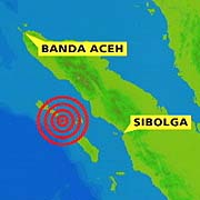
Epicenter of the 28
March 2005 Earthquake in relation to the epicenter of the 26
December 2004 and the region affected by the 1861 earthquake
(Modified USGS graphic)
Epicenter - 2.3 NORTH 97.1 EAST LOCATION-
NORTHERN SUMATERA (Sumatra) INDONESIA.
Earthquake Location
- The epicenter
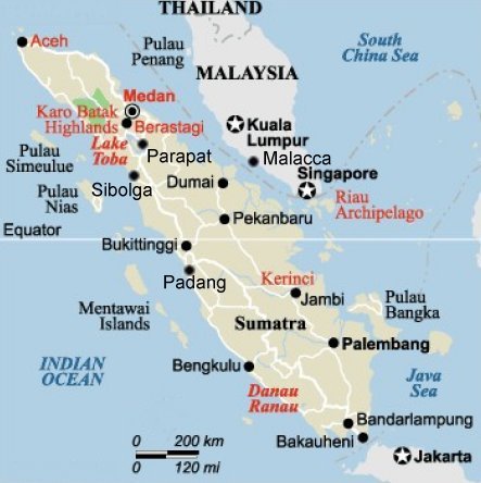
was near the coast of northern Sumatra, about 125 miles west
northwest of Sibolga, slightly southeast of the the 26 December
2004 earthquake's epicenter (nearly 160-kilometers), and along
the same Sunda Trench fault line. However, this time, the epicenter
was about 250 kilometers south-southeast of Banda Aceh.
Earthquake Focal Depth
- The earthquake
was shallow. Its focal depth was 32 kilometers -- which was about
as deep as the 26 December 2004 event.
Felt Reports - There were strong earthquake
motions in the immediate area that reportedly lasted for about
three minutes. Tremors were felt in Indonesia and as far north
as Bangkok, Thailand, Malaysia and Singapore. According to residents
in Singapore, the earthquake tremors were felt more severely
than those of the 26 December 2004 earthquake.
 Aftershocks -
In the hours following the major earthquake a series of aftershocks
struck the region - one with magnitude 6.7. The following day,
Tuesday, at least 13 aftershocks between magnitudes 5.0 and 6.1
hit the region. The aftershocks are expected to continue for
several days, weeks and months. Also, aftershocks from the 26
December 2004 earthquake continue to occur in the Andaman Sea
and elsehwhere, but these can be distinguished by their latitude,
which in further north (more than 3.0 North). Aftershocks -
In the hours following the major earthquake a series of aftershocks
struck the region - one with magnitude 6.7. The following day,
Tuesday, at least 13 aftershocks between magnitudes 5.0 and 6.1
hit the region. The aftershocks are expected to continue for
several days, weeks and months. Also, aftershocks from the 26
December 2004 earthquake continue to occur in the Andaman Sea
and elsehwhere, but these can be distinguished by their latitude,
which in further north (more than 3.0 North).

THE
28 MARCH 2005 EARTHQUAKE AND AFTERSHOCKS IN THE ANDAMAN AND NICOBAR
ISLANDS AND IN THE NORTHERN SUMATRA (SUMATERA) REGION
(listing
includes aftershocks believed to be associated with the 26 December
2004 earthquake - marked in blue)
Selected list of automatic
GEOFON earthquake locations (as of 2005/03/30) from the GEOFON
Extended Virtual Network - "GEVN" compiled by many
real-time stations from partner networks in Europe and around
the globe (IRIS GSN, USA).(GEOFON home page geofon_dc@gfz-potsdam.de)
Origin Time Epicenter
Mag. Flinn-Engdahl Region Name Type
2005/03/30
08:27:49 4.0 N 97.9 E mb=4.6 NORTHERN SUMATERA, INDONESIA L
2005/03/30 02:06:17 1.9 N 98.0 E mb=5.0 NORTHERN SUMATERA, INDONESIA
L
2005/03/30 01:58:32 2.6 N 98.3 E mb=4.8 NORTHERN SUMATERA, INDONESIA
L
2005/03/30
01:13:23 3.6 N 96.5 E mb=5.5 NORTHERN SUMATERA, INDONESIA B
2005/03/29 20:41:38 3.1 N 97.5 E mb=5.1 NORTHERN SUMATERA, INDONESIA
L
2005/03/29 18:29:47 0.7 N 97.6 E mb=5.2 NORTHERN SUMATERA, INDONESIA
L
2005/03/29
18:06:54 5.5 N 96.9 E mb=5.1 NORTHERN SUMATERA, INDONESIA L
2005/03/29 17:20:45 2.5 N 97.2 E mb=5.0 NORTHERN SUMATERA, INDONESIA
L
2005/03/29
16:21:48 6.7 N 97.1 E mb=5.0 NICOBAR ISLANDS, INDIA L
2005/03/29 14:16:05 2.4 N 96.2 E mb=5.3 NORTHERN SUMATERA, INDONESIA
L
2005/03/29
12:55:58 5.9 N 95.1 E mb=5.1 NORTHERN SUMATERA, INDONESIA L
2005/03/29 10:56:53 2.4 N 96.4 E mb=5.2 NORTHERN SUMATERA, INDONESIA
L
2005/03/29 06:16:15 1.5 N 98.7 E mb=5.2 NORTHERN SUMATERA, INDONESIA
L
2005/03/29 05:16:31 2.9 N 96.0 E mb=6.0 OFF W COAST OF NORTHERN
SUMATERA B
2005/03/29 04:19:00 1.4 N 97.7 E mb=5.3 NORTHERN SUMATERA, INDONESIA
L
2005/03/29 02:22:51 2.8 N 96.3 E mb=5.2 NORTHERN SUMATERA, INDONESIA
L
2005/03/29 00:56:00 1.8 N 97.7 E mb=5.1 NORTHERN SUMATERA, INDONESIA
L
2005/03/28
23:37:33 4.2 N 96.8 E mb=5.6 NORTHERN SUMATERA, INDONESIA B
2005/03/28 23:13:01 0.5 N 96.5 E mb=5.9 OFF W COAST OF NORTHERN
SUMATERA B
2005/03/28 22:41:21 1.9 N 96.6 E mb=5.1 OFF W COAST OF NORTHERN
SUMATERA L
2005/03/28 21:34:11 1.9 N 97.2 E mb=5.2 NORTHERN SUMATERA, INDONESIA
L
2005/03/28 20:35:18 2.4 N 97.2 E mb=5.2 NORTHERN SUMATERA, INDONESIA
L
2005/03/28 20:23:27 2.0 N 97.1 E mb=5.2 NORTHERN SUMATERA, INDONESIA
L
2005/03/28
20:19:09 5.0 N 92.1 E mb=5.2 OFF W COAST OF NORTHERN SUMATERA
L
2005/03/28 20:06:32 1.0 N 95.2 E mb=5.2 OFF W COAST OF NORTHERN
SUMATERA L
2005/03/28 19:26:52 3.6 N 97.7 E mb=5.4 NORTHERN SUMATERA, INDONESIA
L
2005/03/28 19:02:19 1.6 N 98.0 E mb=6.0 NORTHERN SUMATERA, INDONESIA
B
2005/03/28
18:48:58 4.3 N 96.0 E mb=5.8 NORTHERN SUMATERA, INDONESIA B
2005/03/28 18:30:49 2.2 N 97.1 E mb=6.4 NORTHERN SUMATERA, INDONESIA
B
2005/03/28 17:59:49 1.7 N 97.3 E mb=5.9 NORTHERN SUMATERA, INDONESIA
B
2005/03/28 17:39:56 0.1 N 95.6 E mb=5.5 OFF W COAST OF NORTHERN
SUMATERA L
2005/03/28 17:29:21 3.5 N 95.5 E mb=5.8 OFF W COAST OF NORTHERN
SUMATERA L
2005/03/28 17:11:44 0.2 S 95.9 E mb=5.9 SOUTHWEST OF SUMATERA,
INDONESIA B
2005/03/28 17:03:30 0.5 N 95.6 E mb=6.2 OFF W COAST OF NORTHERN
SUMATERA B
2005/03/28
16:44:33 3.0 N 95.9 E mb=6.2 OFF W COAST OF NORTHERN SUMATERA
B
2005/03/28 16:38:43 1.5 N 97.3 E mb=6.4 NORTHERN SUMATERA, INDONESIA
B
2005/03/28 16:34:48 2.7 N 96.9 E mb=6.5 NORTHERN SUMATERA, INDONESIA
B
2005/03/28 16:09:33 2.2 N 97.0 E mb=6.5 NORTHERN SUMATERA, INDONESIA
X
2005/03/27
06:09:22 4.0 N 94.7 E mb=5.1 OFF W COAST OF NORTHERN SUMATERA
L
2005/03/25 21:58:03 3.2 N 95.8 E mb=4.8 OFF W COAST OF NORTHERN
SUMATERA L
2005/03/25 03:27:18 8.0 N 94.1 E mb=4.8 NICOBAR ISLANDS, INDIA
 Crustal Displacements and Rupture Crustal Displacements and Rupture
The distribution of
the larger aftershocks indicates that the two tectonic plates
(the Australian plate and the Burma subplate) slipped for about
160-200 km along their boundary. The aftershocks extend from
0.1 N to approximately 2.5 -3.0 degrees N). Therefore, the length
of the overall rupture is estimated to be about 160 -200 km.
- southeast of the rupture zone of the M9.0 earthquake
of 26 December 2004.
The slippage occurred
along a section of the great fault that parallels the Sunda Trench.
The rupture started near the epicenter off the western coast
of North Sumatra in the vicinity of Nias Island and progressed
in a southeast direction along a preexisting major fault - the
same segment that ruptured during the 1861 earthquake - and generated
a locally destructive tsunami.
Map of Sumatra showing
Simeulue Island to the west near the epicenter of the 26 December
2004 earthquake where uplift and elongation of the island were
observed and reported. Note proximity to Lake Toba, the submerged
caldera of the volcano which, about 75,000 years ago, was the
site of the greatest volcanic explosion on earth in the last
two million years. The explosion of Toba sent 2,800 cubic kilometers
of material into the earth's atmosphere and caused major climatic
changes
It has been estimated
that this megathrust faulting along the Australian and Burma
boundary has resulted in a major shift (with dimensions to be
reported at a later time when the data is further analyzed).
Partial vertical upward movement of the sea floor has occurred
and a small tsunami was generated by the upthrusting motion.
Field surveys on Simeulue and Nias islands, off Summatra - when
completed - will provide better estimates of net crustal movements.
Earthquake Damage
and Death Toll -
Hundreds of people died as a result of this earthquake. Both
Nias and Simeulue Islands were heavily damaged. Nias Island appeared
to be the hardest hit, with lighter damage on nearby Simeulue
and Banyak Islands. Extensive damage was caused by the quake
in the city of Gunung Sitoli, on the island of Nias, where more
than 200 buildings were destroyed and landslides closed the road
to the main airport on Nias. The official death toll was initially
given as 330 with 230 of those killed on Nias Island and 100
on Simeulue Island. The death toll has been revised and at least
600 have been confirmed as dead on Nias Island alone. It is expected
that the death toll may eventually rise to 2,000 or even more.
More than 140,000 people were left homeless in the area. A similar
earthquake in the same area in 1861 killed several thousand people.
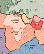 Tectonic Setting Tectonic Setting
The region where the
great earthquake occurred on 28 March 2005, marks the seismic
boundary formed by the movement of the Australian plate as it
collides with the Burma subplate, which is part of the Eurasian
plate. As previously reported the Indo-Australian tectonic plate
may not be as coherent as previously believed. According to recent
studies reported in the Earth and Planetary Science Letters (vol
133), it apears that the two plates have separated many million
years ago and that the Australian plate is rotating in a counterclockwise
direction, putting stress in the southern segment of the India
plate, as well as on the western section of the Burma plate.
For millions of years
the India tectonic plate has drifted and moved in a north/northeast
direction, colliding with the Eurasian tectonic plate and forming
the Himalayan mountains. As a result of such migration and collision
with both the Eurasian and the Australian tectonic plates, the
Indian plate's eastern boundary, as well as that of the Australian
plate, is a diffuse zone of seismicity and deformation, characterized
by extensive faulting and numerous large earthquakes.
The epicenters of
both the 26 December 2004 and of the 28 March 2005 great earthquakes
were near the triple point tectonic junction where major earthquakes
and tsunamis have occurred in the past.
Previous major earthquakes
have occurred further north, in the Andaman Sea and further South
along the Sumatra, Java and Sunda segments of one of the earth's
greatest fault zones, the subduction zone known as the Sunda
Trench. This great trench extends for about 3,400 miles (5,500
kms) from Myanmar (Burma) south past Sumatra and Java and east
toward Australia and the Lesser Sunda Islands, ending up near
Timor. Slippage and plate subduction make this region highly
seismic. The volcanoes of Krakatau, Tambora and Toba, well known
for their violent eruptions, are byproducts of such tectonic
interactions.
In addition to the
Sunda Trench, the Sumatra fault is responsible for seismic activity
on the Island of Sumatra. This is a strike-slip type of fault
which extends along the entire length of the island.
The Burma plate encompasses
the northwest portion of the island of Sumatra as well as the
Andaman and the Nicobar Islands, which separate the Andaman Sea
from the Indian Ocean. Further to the east, a divergent boundary
separates the Burma plate from the Sunda plate.
More specifically,
in the region off the west coast of northern Sumatra, the India
plate is moving in a northeastward direction at about 5 to 5.5
cm per year relative to the Burma plate. It is assumed that the
Australian plate is also moving toward the northeast direction
and at the same rate (about 5 cm/year) against the Sunda plate
to take the slack of the Indian plate's movement. However, it
may be also rotating - at an unknown rate - in a counterclockwise
direction.
The earthquake of
March 28, 2005 was probably triggered by dynamic stress loading
caused by the 26 December 2004 (M9.0) earthquake. The March 28
earthquake occurred - as a result of thrust faulting - on the
boundary of the Australian and Sunda plates. It was caused by
the release of stresses when the Australian plate subducted (and
perhaps rotated) beneath the overriding Sunda plate. This interaction
results in convergence at the Sunda Trench and involves oblique
movement, which is part thrust-faulting along the plate boundary
and involves both slip perpendicular to the trench axis, but
also strike-slip faulting on the great Sumatra fault on the island
- with the orientation of that slip also paralleling the great
Sunda Trench.
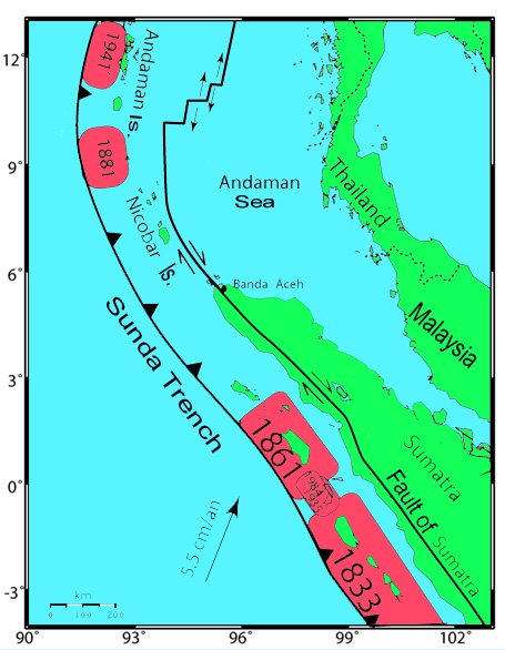
Seismicity of the Region
Earthquakes originate
at two principal tectonic sources in Indonesia. The major tectonic
feature in the region is the Sunda Arc that extends approximately
5,600 km between the Andaman Islands in the northwest and the
Banda Arc in the east. The Sunda Arc consists of three primary
segments; the Sumatra segment, the Sunda Strait Segment and the
Java Segment. These locations represent the area of greatest
seismic exposure, with maximum earthquake magnitudes of up to
7.75 or even more on the Richter scale
The region where the
28 March 2005 earthquake occurred is a very active seismic area.
Sumatra is in the center of one of the world's most seismically
active regions. Earthquakes with magnitude greater than 8 struck
Sumatra in 1797, 1833, and 1861. Earthquakes with magnitude greater
than 7 struck offshore islands in 1881, 1935, 2000, and 2002.
 British
Geological Survey graphic of the seismicity of Southern Asia
(note high concentration of earthquakes in the Andaman Sea and
Northern Sumatra)
British
Geological Survey graphic of the seismicity of Southern Asia
(note high concentration of earthquakes in the Andaman Sea and
Northern Sumatra)

USGS
Map of Past Earthquakes in the Region
Past Earthquakes in
the Region
The most recent magnitude
8+ earthquake in the immediate region of this earthquake occurred
in 1861. The 1861 earthquake generated a regionally destructive
tsunami. Another earthquake of similar magnitude occurred further
south in 1833.
1797: > 300 fatalities at Padang,
M 8.4 EQ
1833: Numerous victims at W Sumatra,
M 8.7 EQ
1843: Many fatalities at the coast
of Nias Island
1861: 1000s fatalities at W coast
of Sumatra, M 8.5 EQ
1881: India's eastern coast, M 7.9
EQ
1883: 36,000 fatalities on islands
of Java & Sumatra, Krakatau explosion
1941: M ~7.7 Adaman Islands EQ ( tsunami
poorly documented
Future Earthquakes,
Volcanic Activity and Tsunamis in the Region
Great earthquakes
do not occur with great frequency on earth. Great earthquakes
occur on the average every ten years. In the 20th century there
have been about a dozen earthquakes with magnitude greater than
8 that can be characterized as great.
For two great earthquakes
to occur so close to each other in time and space - as the 26
December 2004 and the 28 March 2005 events - is very unusual.
However, the northern segment of the great Sunda Trench is a
seismically unusual region of the world, characterized by very
active interaction between the Indian and Australian tectonic
plates and the Burma and Sunda subplates of the Eurasian tectonic
block.
Both of the recent
earthquakes had their epicenters near the triple junction point
where the Indian, Australian and Burma tectonic plates meet.
Triple junction points of tectonic plates, particularly in areas
of active subduction, are some of the most seismic areas of the
world - capable of causing great earthquakes and tsunamis. The
1960 Great Chilean Earthquake and Tsunami originated near such
a triple point tectonic junction.
Usually, when a great
earthquake occurs, most of the stress is relieved and another
great earthquake may not occur for many years in the same region.
However, this is not always the case, as dynamic stress loading
can accelerate the occurrence of another earthquake along an
adjacent seismic zone. Sometimes the opposite occurs and the
release of energy on one segment, may also release stress on
an adjacent seismic fault. In this case it appears that the process
was accelerated rather than delayed.
When the 26 December
2004 earthquake occurred, the Indian plate subducted the Burma
plate and moved in a northeast direction. This movement caused
dynamic transfer and loading of stress to both the Australian
and Burma plates, immediately to the south, on the other side
of the triple junction point. As a result of this load transfer,
the Australian plate moved in relation to the Burma plate and
probably rotated somewhat in a counterclockwise direction, causing
the great earthquake of 28 March 2005. The block that moved was
relatively small in comparison. Whether this movement will now
stress load another segment of the great Sunda fault to the South
and cause another earthquake soon, is not known. However, another
great earthquake similar to that of 1833 (magnitude 8.7) along
the south coast of the western Sumatra, will eventually occur.
That particular earthquake generated a great tsunami. The waves
may have been as much as 10 t0 15 meters on the western coast
of Sumatra. Luckily, most of the energy from that tsunami was
directed towards the unpopulated regions of the southwest Indian
Ocean. When such an event will occur again, is not known. The
only thing known with certainty is that it will occur in this
region. Thus, a Coulomb stress transfer analysis, based on rupture
parameters and the geometric distribution of aftershocks for
both the 26 December 200 and the 28 March 2005 events, would
help establish the space-time evolution of stresses and help
determine both static and dynamic modifications that could possibly
trigger future events along known faults in the region.
In summary, major
earthquakes can be expected to occur further southeast along
the central coast of Sumatra in the next few months. Any such
major earthquake with magnitude greater than 7 could generate
a tsunami in the region. Also, Talang volcano on Sumatra could
experience a major eruption.
The
Tsunami of 28 March 2005 in the Indian Ocean
 Tsunami Warnings Issued Tsunami Warnings Issued
A small tsunami was
generated by the earthquake. The Pacific Tsunami Warning Center
in Honolulu issued a Bulletin advising authorities to evacuate
coastlines within 600 miles of the quake's epicentre. Authorities
reacted more effectively this time in dealing with this earthquake.
Thailand issued a tsunami warning for its west coast. Malaysia
urged residents along parts of its west coast to evacuate. Sri
Lanka also issued a warning and evacuated the eastern town of
Trincomalee. India issued a preliminary warning for the Andaman
and Nicobar islands. But no tsunamis were reported along Indonesia's
island coasts, and India, Thailand and Malaysia canceled the
tsunami warnings.
Small Tsunami Recorded
- A small tsunami
was recorded at tide stations. The Cocos Islands tide gauge near
in the eastern Indian Ocean recorded a wave of 25 centimeters
compared with the 33-centimeter wave recorded after the 26 December
2004 earthquake. A lostnt ed listed in the future.
Explanation for The
Small Tsunami
- Briefly, some of the reasons for the small tsunami from this
great earthquake are the following:
The tectonic mechanism
was different than that of the 26 December event. There was not
as much vertical displacement of crustal material and there may
have been some rotation of the Australian plate with less subduction
and thrusting than the 26 December 2004 event. The rupture along
the fault was shorter. The dimensions of the crustal block were
smaller - about 160-200 km. The earthquake had more of a strike-slip
component which was responsible mostly for horizontal movements
of crustal material. The energy of this earthquake was one half
to one fourth of the energy released by the 26 December 2004
earthquake. The orientation of faulting was such that maximum
tsunami energy propagated toward unpopulated regions of the Southwest
Indian Ocean.
Further
Explanation for the Small Tsunami
Neotectonic processes
along the convergence zone of the Indian and Australian tectonic
plates with the Burma block along the island of Sumatra are controlled
by three major fault systems, the most prominent being that of
the subduction thrust which outcrops in the Sunda Trench. Three
major domains of convergence exist along the Sunda Trench and
the Mentawai trust fault which appear to control the source dimensions
and extent of earthquake ruptures in this very active seismic
region of Indonesia - and thus tsunami generation.
The dynamics of tsunami
generation along western Sumatra are controlled by the shallow
crustal effects resulting from processes of convergence, subduction,
thrusting and extent of displacements of large magnitude, shallow
focus, earthquakes. However, continuing subduction is evident
by a Wadati-Benioff Zone (WBZ) that extends to depths of more
than 200 km and by volcanic activity in the Barisan mountains,
which lie in relatively close proximity to the Sumatran coast.
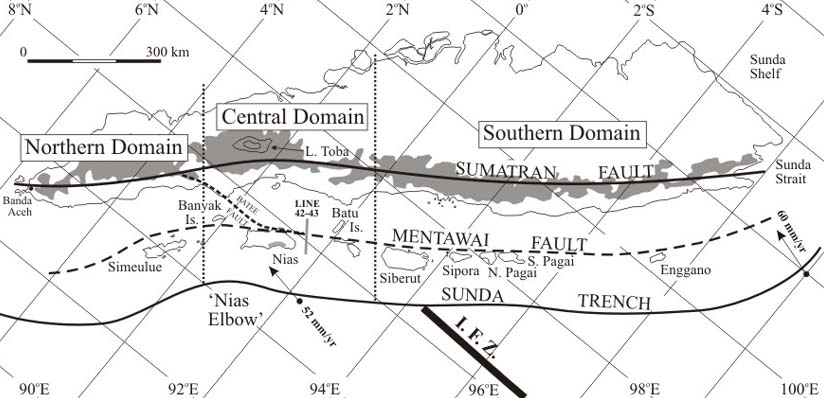 Neotectonics
and major fault systems of the island of Sumatra (Re:John Milsom
Neotectonics
and major fault systems of the island of Sumatra (Re:John Milsom
University College London, UK)
The geometry of convergence,
angle of subduction and existence of thick sedimentary layers,
play an imprortant role on seismic source parameters, seismic
rupture velocity, and on the dynamics of tsunami generation.
The destructive tsunami
of 26 December 2004, occurred along a rupture in the Northern
Domain of convergence but also extended considerably further
north into the thick sedimentary regions of the Nicobar Fan and
of the Andaman Sea - sediments ultimately accumulating because
of Himalayan mountain erosion. Thus, the thickness of the sediments
in the Nicobar Fan and the Andaman Sea may have played an important
role in the destructiveness of this tsunami. Since the earthquake's
rupture appears to have extended into the thick, compacted, sedimentary
layers, a sequential bookshelf type of failure must have occurred.
The slower earthquake rupture velocity in the northern half,
along the Nicobar and Andaman Islands, strongly suggests such
a bookshelf type of failure mechanism (similar to that of the
1992 earthquake and tsunami along Central America). This mechanism
would account for the greater destructiveness of the tsunami
generated along and beyond the Northern Domain of the tectonic
convergence zone - which can also account for the size of the
waves that struck Eastern Sumatra, Thailand and Malaysia to the
east and southeast, and Sri Lanka and India to the west.
The reason why the
28 March 2005 great earthquake did not generate a large destructive
tsunami can also be explained by the gometry of convergence off
central Sumatra, near Nias Island, particularly the 450 km region
known as Nias Elbow. The geometry of convergence in the Central
Domain appears to be greatly affected by the subduction of the
Investigator Fracture Zone and the 2 km high N-S trending Ridge
(IFZ). Apparently the great earthquake of 28 March 2005, was
triggered by stress transferrance of the 26 December 2004 earthquake,
and ruptured the same section along the Central Domain of convergence
as the 1861 earthquake. However, since the 1861 tsunami was much
more destructive, we must conclude that either the rupture was
not as long, or that it involved less thrusting and crustal displacement
- which may also imply that not all the stress in the region
has been released by this earthquake or by the 26 December 2004
event. Therfore, another earthquake further south could be triggered
by possibly continuing stress transferrance.
Also, the geometry
of convergence indicates that in the Southern Domain the Sunda
Trench has a convex orientation towards the Indian Ocean and
that it is not obstructed in any way by fracture zones and ridges.
Therefore, ruptures of major earthquakes along this section -
as in 1833 - can be expected to be much greater in length, dimensions
and thus generate greater destructive tsunamis in the Indian
Ocean - perhaps as large as that of 26 December 2004. Whether
stress transferrance from either the 26 December 2004 or the
28 March 2005 earthquake can trigger another major earthquake
further south in the Central or Southern Domains, is not known
at this time. However, another great earthquake and tsunami,
similar to the 1833 event, can be expected in the future.
Other significant historical
tsunamis in the region
Historical tsunamis
have not been properly documented for the Andaman and Nicobar
Islands, the West Sumatra region, the East and West Coasts of
India, the southern coast of Pakistan or the Indian Ocean in
general. For example, personal communication with residents of
Simeulue Island indicated that a destructive tsunami occurred
around 1907 for which there is no record. There may be several
more events that have not been identified or properly documented.
The following is only a partial list of major known tsunamis
in the Indian Ocean Region. An investigation of additional historical
tsunamis in the Indian Ocean is under way and a more complete
list will be provided at this web site in the near future.
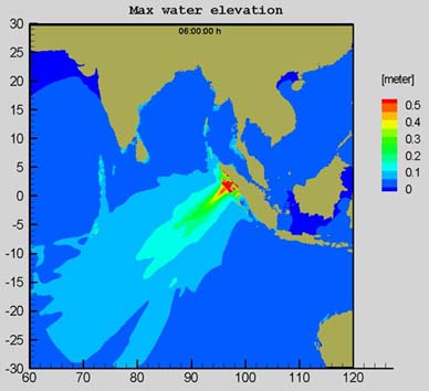 Directivity and height of the
28 March 2005 tsunami (Baybeko, Univ. of Frankfurt) Directivity and height of the
28 March 2005 tsunami (Baybeko, Univ. of Frankfurt)
1797: A magnitude 8.4 earthquake near
the central part of the western Sumatra generated a tsunami that
flooded Padang. More than 300 were killed.
1833: A magnitude 8.7 earthquake near
the south coast of the western Sumatra triggered a huge tsunami
that flooded the southern part of western Sumatra. Numerous victims.
No details.
1843: A tsunami that came from the
southeast and flooded the coast of the Nias Island. Many fatalities
reported.
1861: A magnitude 8.5 earthquake affected
all the western coast of Sumatra. Several thousand fatalities.
1881: A magnitude 7.9 earthquake in
the Andaman Island region generated a 1 m high tsunami on India's
eastern coast.
1883: Krakatau explosion. About 36,500
fatalities, primarily on the islands of Java and Sumatra.
1941: A magnitude ~7.7 Adaman Islands
earthquake. A tsunami occurred, however, no official records
exist.
LINKS TO PAST
AND RECENT EARTHQUAKE AND TSUNAMI DISASTERS IN SOUTHEAST ASIA
AND THE SOUTHWEST PACIFIC OCEAN
THE
GREAT EARTHQUAKE AND TSUNAMI OF 26 DECEMBER 2004 IN THE INDIAN
OCEAN
Tsunamis
of the Indian Ocean
INDONESIA
1883 : Near and Far-Field Effects of Tsunamis Generated by the
Paroxysmal Eruptions, Explosions, Caldera Collapses and Slope
Failures of the Krakatau Volcano in Indonesia, on August 26-27,
1883
INDIA 2002 - The Earthquake of January 25, 2001
in India
PAPUA
NEW GUINEA 1998 - he Tsunami of 17 July 1998 in Papua -New Guinea
INDONESIA
1977 : The Earthquake and Tsunami of August 19, 1977
INDONESIA
1883 : The Great Tsunami of August 26, 1883 from the Explosion
of the Krakatau Volcano ("Krakatoa")
PILIPPINES
1976 - The Earthquake and Tsunami of August 16, 1976 , in the
Philippine Islands
VANUATU
1999 - The Earthquake and Tsunami of November 26, 1999 in Vanuatu
Return to

  Links to other
Pages
Links to other
Pages

 Now available
from Amazon, Barnes and Noble and other major bookstores. A signed
by the author copy can be also ordered by contacting directly
by email Aston
Forbes Press.
Now available
from Amazon, Barnes and Noble and other major bookstores. A signed
by the author copy can be also ordered by contacting directly
by email Aston
Forbes Press.
 Other
Miscellaneous Non-technical Writings
Other
Miscellaneous Non-technical Writings
(©) Copyright
1963-2007 George Pararas-Carayannis / all rights reserved / Information
on this site is for viewing and personal information only - protected
by copyright. Any unauthorized use or reproduction of material
from this site without written permission is prohibited.
|