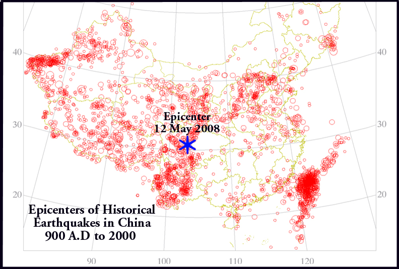
Historical Earthquakes in China
George Pararas-Carayannis
(Excerpts from Unpublished Manuscript)

 INTRODUCTION
Collision
of India with the Asian mainland during the earliest
Eocene (~50 Ma) has resulted in the growth of the
world's largest orogenic belt, the Himalayas, and
the associated Tibetan plateau. The seimotectonic
tectonic evolution of China is characterized by the
merger of several microcontinents throughout the
entire Phanerozoic (Zhang
et al., 1984; Hendrix and Davis, 2001). The
collision and associated convergence and extension
has created 64 major tectonic zones in China, which
can be subdivided into a smaller number of tectonic "regions" (Zhang
et al.,1984; Yin and Nie,1996).
Thus, China is located in one of the most active seismic regions
of the world that has been plagued by numerous
destructive earthquakes
during its long history. The most significant of the historical
earthquakes, in terms of lives lost, was that which occurred
in 1556. However, since 1900 China has experienced
several more destructive earthquakes. The most destructive
earthquakes of the 20th Century were those of
1927 in Tsinghai, of 1932 in Gansu, of 1933 in Sichuan,
of 1969 in Bohai Sea,
of 1970 in Tonghai (Yunnan), of 1974 in Zhaotong (Yunnan),
of 1975 in Haicheng, and of 1976 in Tangshan (Hebei Province)
. The
more recent earthquake of May
12,
2008 in Sichuan Province was
the latest
of the more destructive earthquakes that have struck
China in the new millennium. The following is a brief account
of the 1556 event and of some of the more destructive earthquakes
since 1900.
The
Great China Earthquake of 1556
The worse natural disaster in recorded history - at least
in terms of lives lost - was caused by an earthquake
in Hausien, in the
Shaanxi Province of China in the morning
of 23 January 1556. In
Chinese historical record, this event is often referred as
the "Jiajing Great Earthquake" because it occurred
during the reign of Emperor Jiajing of the Ming dynasty.
The
"Shaanxi Earthquake" as it became later known,
had an estimated magnitude ranging from 8.0 to 8.3
on the
Richter scale (final assigned Moment Magnitude of 8), and
had an estimated intensity of XI on the Modified Mercalli
scale. Its epicenter was near
Mount Hua in Shaanxi, close to present
day Weinan city.
The earthquake was responsible for the devastation
of
98
counties
and eight
provinces in Central China, but particularly destructive
in the Province of Shaanxi. The
destruction extended over an area of 500 miles. In
some of the counties, the average death toll was estimated
to be about 60 percent of the population.
According to historical records, a total of 830,000 people
lost their lives, most from the collapse of
poorly
constructed houses and of Loess cave dwellings.
 Destructive
Earthquakes in China in the 20th Century in relation to
the most recent earthquake of May 12, 2008 (modified graphic
of Western Australia Un.)
Destructive
Earthquakes in China in the 20th Century in relation to
the most recent earthquake of May 12, 2008 (modified graphic
of Western Australia Un.)
The
Haicheng
Earthquake of February 4, 1975
On February 4, 1975, Haicheng, a town with about 100,000
inhabitants in the Liaoning Province of northeast China,
was struck by
a 7.3 magnitude earthquake. As early as 1970, the State
Seismological Bureau, had identified the Liaoning Province
as an area of
high
earthquake risk. Six months before the earthquake,
there had been a series of smaller quakes in the region
- which intensified on February 3rd.
Based
on studies of such precursor events and on unusual behavior
exhibited
by animals, a warning was issued by local
authorities on February 3rd and in the
early morning of February 4th.Thus, when the earthquake
struck at 7:36 p.m. that evening of February 4, there
were few lives
lost as most inhabitants had evacuated to safer places.
The death toll was relatively smaller than what could have
been without the warning. Only 1,328 people lost their
lives. However property damage was high.
 The
Tangshan Earthquake of July 28, 1976
The
Tangshan Earthquake of July 28, 1976
No other earthquake in this century has been as
catastrophic or has claimed as many lives as
the earthquake
that struck the city of Tangshan in Northern
China on July 28, 1976 (27 July 1976 local date). Tangshan,
a thriving industrial city with one million inhabitants,
is
located
in the Province
of Hebei, about
95
miles east
and slightly south
of Beijing and about 280 miles southwest
of Haicheng - where in the previous year another very destructive
earthquake had occurred. Although
the region had experienced moderate
seismic activity
in the past, there were no foreshocks this
time, and no warning.
China's
Seismic Zones
Collision
of India with the Asian mainland during the earliest
Eocene (~50 Ma) has resulted in the growth of the
world's largest orogenic belt, the Himalayas, and
the associated Tibetan plateau. The seimotectonic
tectonic evolution of China is characterized by the
merger of several microcontinents throughout the
entire Phanerozoic (e.g. Zhang et al., 1984; Hendrix
and Davis, 2001).The
collision and associated convergence and extension
has created 64 major tectonic zones in China, which
can be subdivided into a smaller number of tectonic "regions" (Zhang
et al.,1984; Yin and Nie,1996.
The
eartquake (with a magnitude reported in the literature as
ranging from 7.5 to 8.0), struck at 3:42 a.m. in
the early morning hours of July 28, the
worst time when the city was
asleep. What
made matters worse, was the fact that this city is located
in the center of an area with major crustal
faults on four sides and most structures had been built
on unstable, alluvial soils.
Only
a few
of its structures were earthquake-resistant. The earthquake,
with
its epicenter
right on Tangshan, broke a five-mile section
of a 25-mile long fault that passes through the
city. Along
the west side of this fault the land moved five feet northward
in relation to the land on the east side. The east block
tipped downward at the northern end of the break and upward
toward the south end.
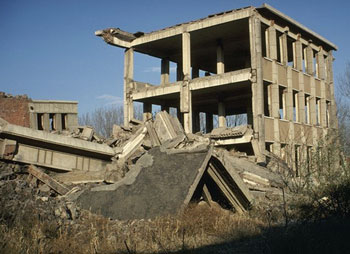 Hotel
in Tangshan
Hotel
in Tangshan 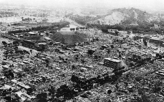
Complete
Destruction of the City of Tangshan by the July
28, 1976 Earthquake (Photo
source: China Earthquake Administration)
Ground
motions lasted for about 90 seconds and, during this time
interval, about 90 percent
of the houses
and buildings in Tangshan collapsed. Over
a four-by-five mile area the devastation of the city was
nearly total. The force of the ground motions
were so strong that people reported being thrown in the
air. Within seconds, thousands died. Property destruction was
unbelievable. Bridges, railroads, homes, factories were
completely
leveled.
In
the harbor city of Tientsin, 60 miles to the southwest,
and in Beijing to the west, the strong ground motions
forced thousands of frightened people into the streets seeking
refuge
from
the aftershocks. The extent of the destruction and number
of deaths in Tangshan and elsewhere
in the region has been uncertain. According
to official reports a total of 242,769 people died
and 169,851
were severely
injured. However, based on the density of population,
it was fairly accurately
estimated that there were at least
655,000 people dead and 780,000 injured. These
figures make
the 1976 Tangshan
earthquake,
the
second worse earthquake in recorded
history. The most destructive
earthquake ever, as reported earlier,
occurred in
1556.
Since
1976 the city of
Tangshan has been growing and its population has increased
by more than 50 percent. A number of new structures have been
built, including high rise structures like the Phoenix
Hotel with a height of 112 meters. Although most stuctures
built since 1976 have been designed to be earthquake resistant
and in accordance to revised seismic construction codes,
it is still uncertain what damage could be inflicted on the
city of Tangshan when another stong earthquake strikes again
in the future.

REFERENCES AND ADDITIONAL READING
Hendrix,
M.S., and Davis, G.A., 2001, Paleozoic and Mesozoic tectonic
evolution of central Asia: from continental assembly to
intracontinental deformation: Boulder, Colo., Geological
Society of America, vi, 447 p.
Yin,
A., and Nie, S., 1996, A Phanerozoic palinspastic reconstruction
of China and its neighboring regions, in Yin, A., and Harrison,
T. M., eds., The Tectonic evolution of Asia: Cambridge [England]
; New York, Cambridge University Press, p. 442-485.
Zhang,
Z.M., Liou, J.G., and Coleman, R.G., 1984, An outline of
the plate tectonics of China: Geological Society of America
Bulletin, v. 95, p. 295-312.

| |
|
©1982 - 2011 Dr. George Pararas-Carayannis - All rights reserved
Last update: March 23, 2013 |
|
|
| |
|
|
|
|
|