|
|
A Brief History of the Samoan Islands
George Pararas-Carayannis
(Excerpts
from a study of Historical Tsunamis in the Samoan Islands
undertaken for the
U.S. Army Corps
of Engineers,
published originally as a Tsunami Catalog of the International
Tsunami Information Center under the authorship of G. Pararas-Carayannis
and B. Dong
in June 1980)
Introduction
The Samoan Islands consist of three large islands,
Savaii, Upolu, and Tutuila, with several neighboring smaller
ones .
The smaller islands are Aunulu, Ta'u, Ofu, Olosega, Rose
and Swains.
The latter two islands are coral atolls . The islands
are of volcanic origin and form a chain from east to west
from 169.5O W
t o 172.0 W a t the approximate mean latitude of 14 degrees.
T he islands rise rapidly from the ocean floor from depths
of over
4,000 meters.
American Samoa consists of several islands east of the
171st meridian of west longitude. It is separated
from Western Samoa
by a Strait which is 60 kilometers wide and over 2,000
meters deep. The main island is Tutuila with an area
of 135 square kilometers. There are six smaller islands,
Aunu'u,
Talu, Ofu, Olosega and a small isolated double island,
Rose Island, which
is uninhabited. The population o f American Samoa, in 1977,
wa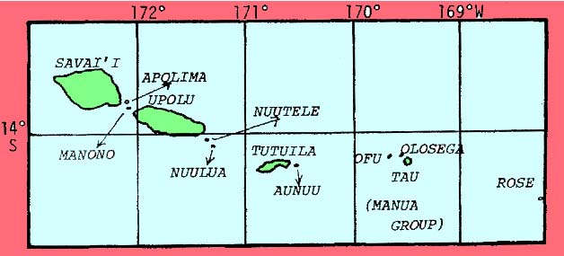 30,600
with the bulk of the population (over 28,000) living
in Tutuila and the remainder in Manua and
Swain's Islands. More than a third of
the population (1 1,000) lives i n Pago Pago which
i s the main town and administrative center of American Samoa.
Approximately 2,000 people live in the other town of
Leone, about 20 kilometers away. The rest of the population
reside in rural
communities.
30,600
with the bulk of the population (over 28,000) living
in Tutuila and the remainder in Manua and
Swain's Islands. More than a third of
the population (1 1,000) lives i n Pago Pago which
i s the main town and administrative center of American Samoa.
Approximately 2,000 people live in the other town of
Leone, about 20 kilometers away. The rest of the population
reside in rural
communities.
The Samoan Group of Islands
The larger islands of Western Samoa are Upolu (70 kilometers by20 kilometers), and Savai ' i (70 kilometers by 50 kilometers). The smaller islands are Nuutele and Nuulua, on the eastern end o f Upolu, and Manono and Apolima, between Upolu and Savai'i. The strait separating Upolu and Savai 'i i s 15 kilometers wide and about 100 meters deep. The islands are surrounded almost entirely by coral reef o f several kilometers i n width. The principal town of Western Samoa and the capital , Apia, is situated on the north coast o f Upolu Island. The total area of Western Samoa exceeds 2,900 square kilometers. Western Samoa is an independent state and a member of the British Commonwealth. Its population as of 1977, was 152,000. Approximately 109,500 people inhabit Upolu and approximately 42,000 inhabit Savai'i (as of 1977).
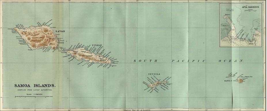
1899 Map of the Samoan Islands
Brief History of the Samoan Islands
Archaeological
excavations in Western Samoa revealed Lapita pottery dating back
to about 800 B.C. Therefore,
it can be assumed
that all of the Samoan Islands have
been inhabited by people for over 2,500 years. Contact with
the western world was first made in 1722 when the Dutch navigator
Jaco Roggereen of the Dutch West India Company sighted the Manua
islands, Tau,
Ofu and Olosega, and had brief contact with
the Samoans. Forty-six years later, i n 1768, the French
explorer
Louis Bougainville, touched at the Manua's in his
voyage around the world and bartered trinkets for fresh
food. He was struck by the manner i n which the Samoans handled
t h e i r boats that he named the islands "the Navigator
Islands".
In 1787, another French explorer, La Perouse, visited the islands. During the visit, his second in command, de Langle, and eleven of his men were massacred when they went ashore for water. Four years later, the Englishman Captain Edward Edwards of the British war vessel, "Pandora", stopped on two occasions during his search for the mutineers of the "Bounty". From about 1803 and thereafter, many sailors and escaping convicts from New South Wales began to reach the Samoan islands from Tonga and elsewhere. By 1830 many people of European origin had settled in the Samoan islands. In 1830, the first Christian missionaries, John Williams and Charles Barff of the London Missionary Society arrived and left Tahitian teachers ashore. In 1836, the Rev. A.M. Murray settled on Tutuila, remaining there for many years. Pago Pago harbour had been discovered a few months earlier by Captain Cuthbert of the British whaler "Elizabeth". Pago Pago soon thereafter became a popular port of call for whaling vessels of many nations.
The United States Navy made the first scientific investigations
in the islands in 1839. As early as 1850, England, Germany,
and the United
States were represented by commercial agents in Apia. During
the next 20 years, Germans and Englishmen were more forward
in developing and establishing close relations
with the natives. Americans took very little
interest at this time. Recognizing the usefulness of
Pago Pago
as a port for the proposed trans-Pacific steamship service,
American shipping interests took steps to obtain a foothold
there. In 1872, Commander Richard W. Meade of the United
States Navy signed a treaty with the
Mauga (high  chief)
at Pago Pago area which gave the United States
the
exclusive right to build a naval station in return for
U.S. Government protection. The treaty was made
only
on Meade's own responsibility. Later
that year, President Grant communicated this
agreement to the Senate which gave no action on the agreement.
Finally, in 1878, a treaty which contained the formal definition
of the relations of the United States and the Samoan group
was ratified. The United States was granted the priviledge
of entering and using of Pago Pago, and establishing a coal
station there. During the next 20 years, the Samoan
islands were the subject of power struggles between the United
States, Germany and Great Britain. In
1898, after
a war with Spain, the United States acquired Guam and
the Philippines and shortly thereafter
annexed Hawaii.
chief)
at Pago Pago area which gave the United States
the
exclusive right to build a naval station in return for
U.S. Government protection. The treaty was made
only
on Meade's own responsibility. Later
that year, President Grant communicated this
agreement to the Senate which gave no action on the agreement.
Finally, in 1878, a treaty which contained the formal definition
of the relations of the United States and the Samoan group
was ratified. The United States was granted the priviledge
of entering and using of Pago Pago, and establishing a coal
station there. During the next 20 years, the Samoan
islands were the subject of power struggles between the United
States, Germany and Great Britain. In
1898, after
a war with Spain, the United States acquired Guam and
the Philippines and shortly thereafter
annexed Hawaii.
The Harbor of Apia, Western Samoa in 1899
In 1899, the
remaining Spanish possessions in the Pacific - the Caroline, Palau
and the Marianna Islands were sold to Germany. Also in 1899 treaties
were drawn between the three powers (Germany, USA and Great Britain)
to partition the Samoan Islands. Western Samoa was placed under
Germany. United States
accepted
Tutuila and Manua and Great Britain withdrew from the group
in return for German concessions elsewhere. The American
territory was placed under the jurisdiction of the United States
Department
of the Navy from
1900 to 1951. The United States flag was formally raised on Tutuila
on 17 April 1900 following the receipt of a deed of cession from
the chiefs of that island. The Manua chiefs signed a deed of cession
in 1904. In 1911, American Samoa was adopted as the name of the
territory. In 1951, the administration of American Samoa was transferred
to the U.S. Department of the Interior.
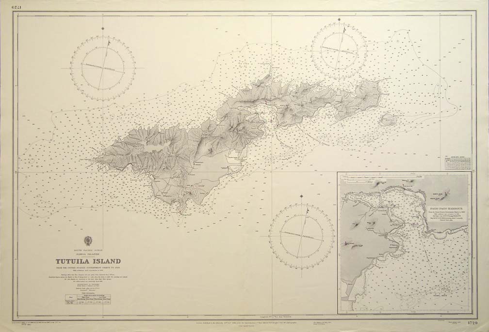
1899 Map of the Island of Tutuila and the harbor of Pago Pago
REFERENCES
DAVIDSON, J.W., 1967. Samoa mo Samoa: The Emergence of the Independent State of Western Samoa, Oxford University Press, Melbourne, Australia.
GILSON, R.P., 1970. Samoa 1830 to 1900: The
Politics of a Multi-Cultural Community,
Oxford University
Press, Melbourne,
Australia.
GRAY. J.A.C., 1960. Ameri ka Samoa: A History
of American Samoa and its United States
Naval Administration, United States Naval
Institute, Annapolis, Maryland.
See also: Short History of Alaska
...............
..................... Tsunami ... Earthquakes .. Seismotectonics .. Hurricanes ... Volcanic Eruptions..Tornadoes..Natural Disasters. Disaster Archaeology. Climate Change . Ocean Governance
Announcements .. Completed Events .. Special Bulletins: Recent Disasters .. Books & Book Reviews .. Tsunami Society
Dr. George Pararas-Carayannis:. Bio Summary .. Publications .. Recent Publications .. Recent Books .. Miscellaneous Writings .. Consulting Services
..................
Web Design by Dr. Carolyn Carayannis © Copyright 2008 / all rights reserved. © Copyright 1963-2007 George Pararas-Carayannis / all rights reserved / Information on this site is for viewing and personal information only - protected by copyright. Any unauthorized use or reproduction of material from this site without written permission is prohibited. Material included at the website links above is for informative and educational purposes and for disaster preparedness only. Any predictions of large earthquakes, destructive tsunamis, or any other natural disasters presented in these pages are based primarily on statistical determinations of the historical recurrence frequencies of such events. Such historical/statistical approaches are used only for long-term predictions. There is no intent by the author to predict or forecast any type of natural disaster or to frighten people.
