|
|
CHINA EARTHQUAKE OF APRIL 13, 2010 IN QINGHAI PROVINCE
George Pararas-Carayannis
Preliminary Report
 INTRODUCTION INTRODUCTION
A major earthquake struck a remote region of Qinghai province of China on Tuesday April 13, 2010, killing many people and causing extensive destruction. The Qinghai province borders the autonomous regions of Tibet and Xingjiang and the provinces of Gansu and Sichuan. On May 12, 2008, a 7.9 earthquake in the neighboring Sichuan province, killed thousands of people.
Qinhai Province
Date and Time of Origin: Tuesday, April 13, 2010 at 23:49:37 UTC, 7:49 am (local time, Wednesday, April 14, 2010 )
Magnitude: Moment
Magnitude 6.9 (USGS); 7.1 (China Earthquake Administration).
Focal Depth: 17 km (10.6 miles) (USGS).
Epicenter: 33.224 N, 96.666 (USGS NEIC, WDCS-D)
Distances: In the Yushu County of the southern Qinghai Province on the Tibetan plateau, 50 km (30 miles) WNW of Gyegu (Yushu), Qinghai, China; 235 miles southeast of the city of Golmud; 240 km (150 miles) NNW of Qamdo, Xizang (Tibet); 375 km (235 miles) SSE of Golmud, Qinghai, China; 520 km (325 miles) SSE of Da Qaidam, Qinghai, China; 370 km (230 miles) WNW of Garze, Sichuan, China; 1905 km (1190 miles) WSW of BEIJING, Beijing, China.
Aftershocks
The USGS recorded three strong aftershocks -- of magnitudes 5.8, 5.2 and 5.3 -- all within two hours of the first quake. At least 18 aftershocks measuring more than 6.0 followed throughout the day.
Death Toll and Damages
The earthquake struck China's Qinghai region in the Tibetan Plateau. The quake centered in Yushu County, a mountainous area sparsely populated by farmers and herdsmen, most of them ethnic Tibetans. This is a remote area with rugged terrain, about 150 miles (240 kms) northwest of Qamdo, Tibet. Although the area is not densely populated, the earthquake killed more than 2,200 people, injured thousands more and resulted in widespread destruction. According to reports, about 15,000 (approximately 90%) of the homes in the Yushu Prefecture region were destroyed, leaving thousands homeless. Most were wooden and earth-walled houses of poor quality.
Google Earth image of theYushu Tibetan Autonomous Prefecture in the Qinghai Province region of the Tibetan Plateau, striken by the earthquake of April 13, 2010.

Major Faults - Qinghai Province
Two major fault systems cross the Qinghai Province, the
Xianshuihe and the Kunlun. Both fault systems trend in a southeastward direction and are associated with major earthquakes such as the April 13, 2010 event. The epicenter location of the April 13, 2010 event indicates that it occurred along the Xianshuihe fault.
Xianshuihe fault bel - This fault system extends for about 450
km. It is a long left-lateral strike-slip fault zone with
an estimated Holocene slip rate
of about13 mm/yr (Zhang et al.; Papadimitriou
et al., 2004. Earthquakes with magnitude greater than 6.0 occur frequently
and in a
continuous sequence along the Xianshuihe
fault belt. Nine earthquakes with Ms > 7 reportedly have occurred
along this fault zone.
The 1973 Luhuo earthquake (Ms = 7.9) was associated
with 90 km
of surface rupture and a maximum left-lateral displacement of 6 meters (Tang
et al., 1984). Further east the Xianshuihe fault curves
into the longer, north-south trending Xiaojiang seismic belt that tranverses the
Sichuan
and
Yunnan
Provinces. This segment is also reported
to be a source of
major earthquakes - such as the 1833 Songming earthquake (Ms = 8).
Kunlun fault belt - The is a major strike-slip fault system on the north side of Tibet, crossing Qinghai province. Similarly, there is left-lateral movement of crustal blocks along its 1,500-kilometer (932-mile) length. Uniform crustal movement along this Kunlun fault system in the last 40,000 years at a rate of about 1.1 cm/ year, has created an offset toataling more than 400 meters. The Kunlun mountain range - with average elevation of 5,000 to 7,000 meters - extends for 2,500 km from the Pamirs Plateau in the west to the northwest of the Sichuan Province.


Tectonics of the Tibetan Plateau - Approximate epicenter locations of the earthquakes
of April 13, 2010 in Qinhai Province and of May 12, 2008, in Shihuan Province. (modified graphic after Liu & Yang 2003).
Past
Earthquakes in China and in the Qinhai Province
During the 20th Century there have been
nine (9) great earthquakes with magnitude greater than
8.0 in China, sixty six (66) with magnitude ranging from
7 to 7.9, and three hundred and eighty-five (385) with
magnitudes ranging from 6 to 6.9. Almost all of these destructive earthquakes
occurred along well-known faults, mainly in China’s Central Region. Since 1500 A.D.,
there have been at least 8 destructive earthquakes with magnitudes
M7.8 or more along in this central belt. The deadliest earthquake on record occurred in 1556, in Shaanxi. It was an intraplate earthquake that killed 830,000 people. In
1976 the Songpan earthquake, with a magnitude of 7.2, occurred
about 100km
from the May 12, 2008 Sichuan earthquake, and killed more than
800 people. A quake in 1981 (Ms=6.9) struck
along the Daofu fault. Finally, an earthquake in 1982
(Ms=6.0) occurred along the Ganzi fault (Qiu-wen
et al, 2003).
On August
25, 1933, a
magnitude 7.5 earthquake in Diexi, Sichuan, (about 60km away
from the May 12, 2008 quake), killed more than 9,300 people and caused widespread landslides that disrupted river
flows. Forty five
days later, a regional dam broke resulting in more than
10,000 fatalities
in the same general area. Another earthquake (Ms=7.6) in
1973 occurred on the Luohuo fault (Zhou et
al., 1983).
An earthquake in 1975 (Ms=6.2) occurred along the Kangding
fault.. The most destructive earthquake (magnitude 7.5) in recent times
was the one that struck the northeastern city of Tangshan
on July 28, 1976. Tangshan is roughly 1,600 km from Chengdu,
the nearest major city to the epicenter of the May 12,
2008 quake. The 1976 event, was the deadliest earthquake
in the last four centuries. The official death toll was
255,000 people, however estimates of as high as 655,000
have been given. More recently in 2003, a 6.8-magnitude
earthquake killed 268 people in Bachu County in the west
of Xinjiang.
Several earthquakes with magnitude greater than 6.0 occur frequently
and in a
continuous sequence along the Xianshuihe and the Kunlun fault systems in the Qinghai Province. As stated, many earthquakes occur also along the longer
seismic belt that tranverses the
Sichuan
and
Yunnan
Provinces.

Destructive
Earthquakes in China

China's
Seismic Zones (modified graphic of China
Earthquake Administration)
Seismotectonic Setting (brief overview)
The
high seismicity of central and eastern Asia results from
the northward collisional
convergence
(at
about
50
mm/y)
of the
India
tectonic
plate against the Eurasian plate. This active collision
- which begun about 55 million
years
ago -
is the cause of frequent large earthquakes between India and Tibet
and throughout Tibet and the surrounding areas in China. The convergence
has uplifted
the Asian highlands and the Tibetan Plateau to an average elevation
of over
16,000 feet - the highest and largest plateau
on Earth - with hundreds
of kilometers of displacement of crustal blocks to the east and
southeast in the direction of China. Three
distinct deformational episodes that occurred 200- 240 million
years ago resulted in initial thrusting and subsequent vertical
extrusion, while later episodes during the Late Cenozoic resulted in folding (Li
et al. 2007) and widespread crustal extension of the Tibetan Plateau. As
India kept on moving northward and intruding into Asia by
as much as 1,200 kms, the regions north of the Himalayas
moved laterally to the east and southeast along large strike
slip faults such as the Altyn Tagh, pushing into central
China and furthermore resulting in the extrusion and movement
of the crustal blocks that formed Indochina. Continuous convergence has formed
the most active and extensive seismic belt in China.
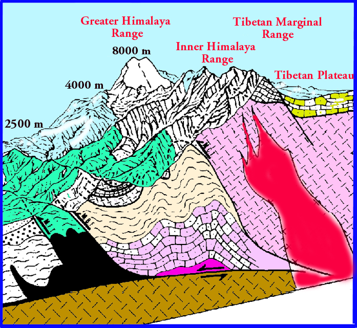 Collision
of the India and Asia tectonic plates resulting in uplift of the Himalayas
and of the Tibetan Plateau and its convergent extension into China
(modified graphic Univ. of Berne, Inst. of Mineralogy). Collision
of the India and Asia tectonic plates resulting in uplift of the Himalayas
and of the Tibetan Plateau and its convergent extension into China
(modified graphic Univ. of Berne, Inst. of Mineralogy).
Tibetan
Plateau crustal extension and effects of syntaxis on
the formation of major fault zones and on crustal motions
in Southcentral China - as indicated by GPS measurements (web
graphic http://www.shangri-la-river-expeditions.com/wchinageo/crustalshear.jpg)

Detachment
of the upper crust in the Tibetan Plateau
has resulted in the formation of anticlinal folds,
ridges, linear mountains and hills, widely separated by
interfold segments (poorly-formed synclines) , and major
fault zones (modified Landsat-1 image). The
geomorphological features of the region also control the
flow of major rivers and the formation of sedimentary accretion
zones where - often - cities are located (a factor which
also contributes to the destructiveness of earthquakes by enhancement of ground motions and
liquefaction).
REFERENCES
and ADDITIONAL READING
Allen,
C.R., Luo Zhuoli, Qian Hong, Wen Xueze, Zhou Huwei, and Huang
Weishi, (1989), Segmentation and rupture history of the Xianshuihe
fault, southwestern China, U. S. Geological Survey Open-File
Report 89-315, 10-31.
Gu
Gongxiu, (1983), Earthquake Catalog of China, Seismological
Press.
Hui-
Lan Zhou, Clarence R. Allen and Hiroo Kanamori, " Rupture
complexity of the 1970 Tonghai and 1973 Luhuo earthquakes,
China, from P-wave inversion, and relationship to surface
faulting". Bulletin of the Seismological
Society of America; December 1983; v. 73; no. 6A; p.
1585-1597.
Ma
Xingyuan, (1989), Lithospheric dynamics atlas of China, China
Cartographic Publishing House, Beijing.
Mian Liu and Youqing Yang, 2003. Extensional collapse of the Tibetan Plateau: Results of three-dimensional finite element modeling. journal of Geophysical Research, Vol 108, No. 8, 2361. JOURNAL OF GEOPHYSICAL RESEARCH, VOL. 108, NO. 8, 2361
http://web.missouri.edu/~lium/pdfs/Papers/LiuJGR03.pdf
Pararas-Carayannis, George, 2006, Earthquakes in China, Excerpts from Unpublished Manuscript. http://www.drgeorgepc.com/EarthquakesChina.html
Pararas-Carayannis, George, 2000, DISASTER RISK ASSESSMENT OF THE CHINA/TAIWAN CROSS-STRAITS REGION, Planning for Disaster Mitigation, Keynote Presentation, 2009 China Cross-Straits Symposium on the Prevention and Mitigation of Natural Hazards - 19-20 JUNE 2009, FUZHOY, CHINA,
http://www.drgeorgepc.com/CrossStraits.pdf (PDF in English); http://www.dregeorgepc.com/CrossStraitsCH.pdf (PDF in Chinese)
Papadimitriou,
Eleftheria; Wen, Xueze; Karakostas, Vassilios; Jin, Xueshen, "Earthquake
Triggering along the Xianshuihe Fault Zone of Western Sichuan,
China", Pure & Applied Geophysics PAGEOPH,
Volume 161, Number 8, August 2004 , pp. 1683-1707(25).
Sanzhong
Li, Timothy M. Kusky, Lu Wang , Guowei Zhang , Shaocong Lai,
Xiaochun Liu, Shuwen Dong,
Guochun Zhao. (In Press). "Collision
leading to multiple-stage large-scale extrusion in the Qinling
orogen:
Insights from the
Mianlue suture". International Association for Gondwana
Research. Elsevier (2007)
Zhang
Qiu-wen, Zhang Pei-zhen , Wang Cheng , Wang Yi-peng and Michael
A Ellis, "Earthquake triggering
and delaying caused by fault interaction on Xianshuihe fault
belt, southwestern
China". Seismological Society of China, Volume 16,
Number 2 / March, 2003.
Zhou
Huilan, Liu H.-L., and H. Kanamori, (1983), Source processes
of large earthquakes along the Xianshuihe fault in southwestern
China, Bull. Seism. Soc. Am., 73, 171-181.
SEE
ALSO:
| |
|
©1982 - 2010 Dr. George Pararas-Carayannis - All rights reserved
Last update: April 28, 2010 |
|
|
| |
|
|
|
|
|
|