 INTRODUCTION
On Wednesday, September 12, 2007,
a great earthquake struck off the southern coast of the island
of Sumatra, killing at least 9 people and generating
a relatively small tsunami. Two other major earthquakes struck
later. A tsunami warning was issued for the immediate area and
watches for adjacent regions.
Origin Time - The great earthquake struck
on Wednesday, September 12, 2007 at 1110 Z (UTC), about 21:10
(AEST), (1810 local time in the Bengkulu province of Indonesia).
Another major earthquake (7.1 magnitude) struck four hours later.
A third earthquake with a 7.8 magnitude struck at 1145 GMT 6:45
a.m. (7:45 p.m. Wednesday ET).
Epicenter - The epicenter of the great earthquake
was off the coast of Southern Sumatra at 4.517 S. 101.382 E.,
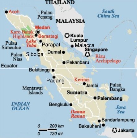
about 185 km south-southeast of Padang, about 130 km (80 miles)
SW of Bengkulu, 410 km (255 miles) SW of Jambi, 620 km (385 miles
WNW of Jakarta and 695 km (435 miles) SSW of Singapore (USGS).
Magnitude - The great earthquake's estimated
Moment Magnitude was initially given as Mw= 8.2. Later , it was
raised to Mw=8.4
Focal Depth - The focal depth was shallow at
30 Km (about 18.6 miles)
Aftershocks - At least 10 aftershocks of magnitude
5.1 to 6.0 were felt in the region after the larger quake. At
least 60 major aftershocks measuring 5.0 and occurred within
the 24-hour period following the main earthquake.
Felt Motions - The earthquakes shook buildings
in the Indonesian capital, Jakarta, about 605 km (375 miles)
southeast of the epicenter, forcing evacuation of several tall
buildings. Shaking at some locations in Singapore (about 435
miles from the epicenter) were so strong that several high-rise
buildings were also evacuated. According to eyewitnesses in Singapore,
the shaking lasted almost a minute.
Deaths and Damages
- Several buildings
in Padang, the capital of West Sumatra, collapsed and some caught
fire. At least nine people were killed in the Bengkulu province
and in Padang. An unknown number of people were injured or were
missing. The death toll is expected to rise. Thousands of homes
were damaged in Sumatra.

 Tectonic Setting
For millions of years
the India tectonic plate has drifted and moved in a north/northeast
direction, colliding with the Eurasian tectonic plate and forming
the Himalayan mountains. As a result of such migration and collision
with both the Eurasian and the Australian tectonic plates, the
Indian plate's eastern boundary is a diffuse zone of seismicity
and deformation, characterized by extensive faulting and numerous
large earthquakes. The region off the west coast of northern
Sumatra, the India plate is moving in a northeastward direction
at about 5 to 5.5 cm per year relative to the Burma plate.
The Indo-Australian
tectonic plate may not be as coherent as previously believed.
According to recent studies reported in the Earth and Planetary
Science Letters (vol 133), it apears that the two plates have
separated many million years ago and that the Australian plate
is rotating in a counterclockwise direction, putting stress in
the southern segment of the India plate.
USGS graphic showing
the migration of the Indian tectonic plate
The earthquake of
September 12, 2007 occurred along the great Sunda Trench off
Central Sumatra and south of the triple point junction of three
tectonic plates where major earthquakes and tsunamis have occurred
in the past. This is a region of active subduction where the
Indian oceanic plate sinks below the Burma subplate, which is
part of the Eurasian plate The relatively young (40 million years)
Sunda Arc has been formed by this active subduction process.
This is a region of extremely high seismicity where great and
major earthquakes occur with frequency. Tectonic movements along
this particular segment of the subduction boundary zone produced
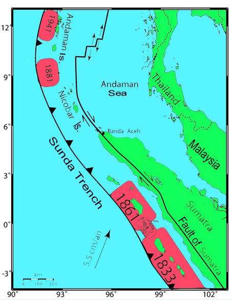
great earthquakes in 1797 and 1833. These had moment magnitudes
estimated at 8.4 and 8.7, respectively. Of the two, there is
geologic evidence that the earthquake of 1833 resulted in a much
greater rupture and uplift of the outer arc islands (Sipora,
and North and South Pagai Islands) and generated a destructive
tsunami.
Recent Earthquakes
in the Region
Since the devastating
tsunami of December 2004, Indonesia has had 15 earthquakes with
magnitudes of 6.3 or greater. These recent quakes killed almost
8,000 people in Indonesia. On May 26, 2006, a moderate, magnitude6.3
earthquake, 16 km south-southeast of Yogyakarta, was responsible
for 5,749 deaths. On July 17, 2006, a magnitude 7.7 earthquake,
145 miles south-southwest of Tasikmalaya in Indonesia's Java
region, killed 730 people. On March 28, 2005, a great earthquake
(Moment magnitude 8.7) centered about 201 km west-northwest of
Sibolga, killed 1,313 people.
THE TSUNAMI
 A small tsunami was generated. The maximum wave
registered by the Padang, tide gauge, north of the quake's epicenter,
was about 60 cm high. The wave amplitude is measured relative
to normal sea level - not crest-to trough wave height. The Padang
tide gauge is located 0.9S 100.4E. The tsunami height at the
tide gauge does not represent tsunami runup. It is only an instrumental
recording by a gauge. Maximum tsunami runup on the open coast
may have been much higher. A maximum tsunami runup height of
90 cm has been reported. The travel time of the first tsunami
wave is estimated at about 20 minutes. The period of subsequent
waves was about 28 minutes.
A small tsunami was generated. The maximum wave
registered by the Padang, tide gauge, north of the quake's epicenter,
was about 60 cm high. The wave amplitude is measured relative
to normal sea level - not crest-to trough wave height. The Padang
tide gauge is located 0.9S 100.4E. The tsunami height at the
tide gauge does not represent tsunami runup. It is only an instrumental
recording by a gauge. Maximum tsunami runup on the open coast
may have been much higher. A maximum tsunami runup height of
90 cm has been reported. The travel time of the first tsunami
wave is estimated at about 20 minutes. The period of subsequent
waves was about 28 minutes.
Tsunami
Warning and Watch
The Pacific Tsunami
Warning Center in Honolulu issued a tsunami warning to the authorities
in the immediate region and a watch for all Indian Ocean areas
including, north-west Australia, India, Sri Lanka, Myanmar, Bangladesh,
Thailand, Malaysia, Sinagapore, Pakistan, Iran, Yemen, Oman,
Mauritius, Seychelles, Madagascar, Reunion I., Comores, Crozet
Islands, Somalia, Mozambique, Kenya, Tanzania, Kerguelen Islands,
and South Africa. No tsunami watch was issued for the Pacific
Region. Indian government authorities issued a separate tsunami
alert for the coastal states of Kerela, Tamil Nadu, Andhra Pradesh,
and the island territories of Andaman and Nicobar.
Evaluation
of the tsunami
Folowing the great
earthquakes of 2004 and 2005, it
appears that there was significant transferrance of tectonic
stress further south/southeast to the central region of Western
Sumatra. In fact the 2005 earthquake occurred in the same region
as the 1861 earthquake. The present earthquake (magnitude 8.2)
of September 12, 2007 and the other two events and aftershocks
(and later a fourth event) occurred even further south/southeast
and within the segment that ruptured when a great (estimated
magnitude Mw=8.7) earthquake occurred in 1833.
Apparently, the September
12, 2007 earthquake had a smaller magnitude and length of rupture
than the 1833 event which generated a much greater tsunami. The
shorter rupture (estimated roughly at about 200 km) and the smaller
magnitude were the probable reasons for the smaller 2007 tsunami.
Fortunately, the energy release by the other two earthquakes
which occurred in sequence, helped release gradually the tectonic
stress in this segment. This may have contributed to the relatively
smaller tsunami that was observed Padang and elsewhere. This
did not occur when the 1833 earthquake struck the same region.
All the energy of the 8.7 earthquake in 1833 was released at
once and the rupture zone may have been as much as 300 km or
even more.
 Earthquakes and tsunamis similar to the 2007
and 1833 events can be expected every hundred years or so in
this segment of the great Sunnda subduction zone. This particular
section of the Sunda megathrust along the western coast of the
northern, central and southern Sumatra, is one of the more
likely sources of destructive earthquakes and tsunamis in the region in the future.
A repeat of single large earthquake with the same rupture and
source dimensions as the 1833 event could again generate a devastating
tsunami that could affect Sumatra and other distant regions of
the Indian Ocean.
Earthquakes and tsunamis similar to the 2007
and 1833 events can be expected every hundred years or so in
this segment of the great Sunnda subduction zone. This particular
section of the Sunda megathrust along the western coast of the
northern, central and southern Sumatra, is one of the more
likely sources of destructive earthquakes and tsunamis in the region in the future.
A repeat of single large earthquake with the same rupture and
source dimensions as the 1833 event could again generate a devastating
tsunami that could affect Sumatra and other distant regions of
the Indian Ocean.
Epicenters of Historical and Recent Earthquakes and Tsunami Generation Areas.
It is still unknown
if all the stress that had built in this segment was completely
eleased. It may not have been released and additional earthquakes
could follow in the next months and years. Also,
other seismic regions further south/southeast were probably energized
by stress transferrance. Major or great earthquakes could occur
further south/southeast in the near future - even sooner than
expected - and have the potential of generating destructive tsunamis.
It remains to be seen if the earthquake of September 12, 2007
resulted not only from partial subduction but also from counterclockwise
rotation of the Australian plate. Such rotation, with diminished
vertical uplift, could account for the smaller 2007 tsunami.
Field studies of uplift and lateral motions on the offshore islands
would confirm if the mechanism of this 2007 event was different
than that of the 1833 tsunami generation mechanism. Field studies
on Sipora, North Pagai and South Pagai Islands of the outer-arc
ridge of the great Sunda Arc, indicate that the great 1933 earthquake
resulted in vertical uplift of up to 2.3 meters. Such extensive
vertical uplift generated the greater tsunami. The uplift caused
by the September 12, 2007 earthquake may have been much lessthan that of 1833.
Future Earthquakes
and Tsunamis in the Region
The earthquakes of
12 September 2007, should not have been a surprise. They should
have been expected. In previous evaluation in this website it
was pointed out that when the 26 December 2004 earthquake occurred,
the Indian plate subducted the Burma plate and moved in a northeast
direction. This movement caused dynamic transfer and loading
of stress to both the Australian and Burma plates, immediately
to the south/southeast, on the other side of the triple junction
point. As a result of this load transfer, the Australian plate
moved in relation to the Burma plate and probably rotated somewhat
in a counterclockwise direction, causing subsequently the great
earthquake of 28 March 2005. The block that moved was relatively
small in comparison. However, this movement stressloaded the
segment further South/Southeast thus causing the September 12,
2007 earthquake in the same region as that which produced the
great earthquake of 1833 (magnitude 8.7). That particular earthquake
generated a great tsunami. The waves may have been as much as
10 t0 15 meters on the western coast of Sumatra. Luckily, most
of the energy from that tsunami was directed towards the unpopulated
regions of the Southwest Indian Ocean.
The earthquake of
September 12, 2007 occurred sooner that was expected. Another
large earthquake could occur again in the same segment in the near future (since the
stress was not totally released - which is what this author believes), or in the segment further south/southeast
along the southern coast Sumatra. When such an event will occur again,
is not known with any degree of certainty. The only thing known with certainty is that a large destructive earthquake
will occur again in this region near Padang and Sumatra's offshore islands. Thus, a Coulomb stress transfer analysis,
based on rupture parameters and the geometric distribution of
aftershocks for the 26 December 2004, the 28 March 2005 and the
12 September 2007 events, could help establish the space-time
evolution of stresses and could help determine both static and
dynamic modifications that could possibly trigger again future large
events along known faults in this region, as well as destructive
tsunamis in the near future. Also, these same seismic events and deeper focus earthquakes under sumatra could activate to a greater extent Mt. Talang volcano near Padang and a large catastrophic eruption is indeed possible.
